Pablo finding all Diez Vistas:
“When I posted the call-out the forecast was sunny, but next day changed to rain. It was raining when we met at the meeting spot, but it stopped before the five of us started hiking. I don’t know why people complain they cannot find the 10 vistas. They are clearly marked Vista #1 to Vista # 10. That doesn’t mean they you will find 10 view points, but the 10 vistas are there. Actually, there are 2 viewpoints before the 10 vistas that are way better. The group was great, we keep a good pace and allowing lots of time to take pictures, but no-one was either running nor staying behind, in fact we stayed together the entire hike. We couldn’t finish the trip without doing the must stop at the ice cream place at the entrance of the park.”
Category Archives: Day hike
Alpaca Peak 14/06/09
Ahmad on Alpaca Peak:
“The trail has three parts: walking on a road, semi bushwhacking following ribbons but no trail, and hiking a ridge which is the most rewarding section. Although there are many ribbons, there are a few sections on which there are none. You need know how to orient yourself. There are a few steep sections on the ridge but not too steep. You don’t need snowshoes at this time but there is still snow on the ridge. We were also lucky with the weather. It was cloudy on the way up and cleared up on the way back which helped to keep the snow not too slushy. The entire hike took us about 10 hours. A long day but worth it.”
Mt Killam 07/06/09
Steve on Mt Liddell Killam:
“After consulting with the Gambier Island Conservatory, we switched from our plan to hike Mt Liddell (overgrown and 2 bridges out), to the one favoured by the latest version of 103 Hikes, Mt. Killam. This trail was straightforward to find and the signage above average. The distinctive orange/silver pattern made us confident we were on the right track, and when no marker was in sight, there was plenty of trail tape. However, there was quite a bit of windfall and dry, dry, twigs to step over (no snow at all). The viewpoint was the best I’ve seen on Gambier, with views of Keats, Bowen, the Paisleys, and Langdale ferry terminal. A big thanks to a good, evenly-paced crew (5 in total) that got up super early to accommodate the ferry schedule (we hiked it in less time than expected). The weather was far better than expected as was the carrot cake from the Gambier General Store”
Levette Lake 06/06/09
Su-Laine at Levette Lake:
“Lots of changes to this trail since the 5th edition of 109 Walks came out in 2002! Forget about trying to count how many private roads emerge on the left on the way to the lake, and just look for the trail entrance (which no longer looks like a road) that’s immediately before the red metal gate and next to the parking lot. The Skyline trail has few red triangle markers described in the books, but lots of yellow round ones now. And the “Blue Trail” connecting the Skyline trail to the road leading to the parking area appears to have been reopened, which considerably shortens the amount of time you have to spend walking on the road. However, the 109 Walks book was very useful on this trip, especially with its detailed map that we found to be accurate.
The trails we used were dry and, despite rumours on the Internet that they’re badly overgrown, well-maintained except for at least one small bridge that looks like it might collapse any day. A few of us walked over the dry creekbed instead of taking the bridge. Even in dry conditions, you need boots with good tread on this trail though. Views of the Tantalus mountains were good, especially from the shores of the attractive Levette Lake itself. Few wildflowers were blooming, but the forest itself, with its soft floor, was lovely to hike through.”

Brohm Lake 06/06/09
Michelle at Brohm Lake and Forest:
“This 2 for 1 hike offered a pleasant casual forest hike on a beautiful sunny day. Though the entrance to Brohm Lake Interpretive Forest doesn’t have its own sign/turning lane (unlike Brohm Lake) it’s easily spotted: after Alice Lake look for a yellow gate on your left with a signboard map right next to it. Signage/trail markers were excellent all along the two inter-linking trail systems (and nary a blow down!). The “fire lookout” offered by far the best views and proved to be a highlight and a most suitable lunch spot. The upper High Trail and Western shore trail of Brohm Lake (a surprisingly large and enjoyable lake) were the most pleasant in both terrain and lake views from above, although the easiest water access points were on the eastern bluffs close to the lake parking lot on the #99 side. You never know what’s hiding just off the shoulder of the highway.“
Lindsay Lake 06/06/09
Robert on the Lindsay Lake trail:
“Our ambitious group of 12 hikers was successful in hiking the trail to Lindsay Lake and Eagle Peak. All the weather forecasts pointed to a sunny day, however we were in the clouds most of the day which provided its navigating challenges. We started the trail from the Buntzen Lake parking lot at 8:30 am and took the route up along Buntzen Creek to El Paso Junction, 100% snow free. From there you have a choice to take the right trail through various lakes or take the left trail to Lindsay Lake. We took the left. About halfway on this trail we hit some snow, which was easy to walk on and finally reached Lindsay lake, about 3.5 hours after our start. Even though it wasn’t sunny, there was a certain atmosphere of being in the clouds and only being able to see a few metres in front. From Lindsay Lake, we took the only route to Triangulation Point and then on to Eagle Peak. It was also here that we met a hiker from Moscow who was lost so we added another member to our group and will soon recruit a new Wanderung member. I would only recommend doing this trail when the weather is clear because in the clouds it was difficult to see the markers since visibility was extremely limited. When we arrived at Eagle Peak we decided to take the Swan Falls trail to the bottom. This trail warns of being steep and obstructed but it actually isn’t bad at all and you come out of the snow very quickly because you lose elevation so quickly. A walk back for half the group along Lake trail and Powerhouse Road for the other half made the end to a long day! Thank you for all your teamwork and eagle eye (no pun intended) scouting for markers.”
Pierce Lake 31/05/09
Ahmad at Pierce Lake (was Mt McGuire):
“The Borden Creek FSR was not accessible. After about 1 km into Borden Creek, there was a disassembled bridge. It looked as it was out for a long while. I had an alternative plan is to use the road that starts on the east of Slesse Creek which has a connection to Borden Creek FSR. That didn’t work either. The road was locked by a gate. Unfortunately the two 4×4 cars, which I thought we were extremely lucky to have, weren’t much of a help. We did Pierce Lake instead which is less than 3 km from where we were. The trail is in good condition except the bridge over Pierce Creek but it was not too hard to cross it. There was still snow on the last 150 m (it started at 1250 m) with a short hard section (but not too hard). No snowshoes were needed. The lake was still mostly frozen. Nice views to Macfarlane from the lake. Six of us did the hike in 7:20 hours. Thanks to Tim and Kelly who warned me that it might not be possible to access Borden Creek FSR”
Mt Grant 24/05/09
Ahmad on Mt Grant:
“No one signed up. Nevertheless I gave it a humble try. The snow conditions didn’t look good and deteriorated quickly with the day heat. The terrain looked untamed – some ribbons but no trail. It looked too rough. I turned back on my first hard step so I cannot comment on how difficult actually it would have been. I believed it would have been some painful postholing. However, the trail to Eaton Lake was in good condition except the bridges. There were 3 broken bridges out of 4. It adds some difficulty. I also saw a couple with a dog, who refused to cross the last broken bridge. The lake was still covered by a crust of ice. There was some snow on the last 70 m of elevation. I should also say that I liked Eaton Trail. It is a forest hike but a nice one.”
Levette Lake 24/05/09
Heather on the Levette Lake loop:
“Kitka, Paul, Janice, Bob and Heather had a great day exploring the Levette Lake loop north of Squamish. The sun was hot, the views fantastic, the air smelled of pine trees, and the wildflowers were in bloom. One of us even went for a breathtaking swim in Levette Lake during the leisurely lunch stop. A pleasant, relaxing hike with lots of variety in the forest and look-out spots.”

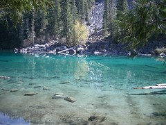
Lindeman & Greendrop Lakes 23/05/09
Paula at Lindeman and Greendrop Lakes:
“There is now a road sign on Chilliwack Lake Road to indicate the location of the trail. The first part of the trail is well marked and we found the steady climb to Lindeman Lake relatively easy, after enjoying a snack and photographing the extraordinary colour of the lake we continued on the trail to Greendrop. We encountered some snow and ice patches making the rock slides more treacherous to cross. About 40 mins from Greendrop, deep in the valley, we found ourselves in deep snow. All the group had worn waterproof hiking boots so we decided to proceed to Greendrop. It was quite a challenge to cross the fast flowing creeks, with snow bridges melting fast – a few ended up with feet plunged into the creek (right through the snow bridge) and another group member took a cold bath! We soldiered on to Greendrop which was half frozen and covered in snow too. Finding a small patch of sun we enjoyed lunch and a few attempted to dry out boots/socks a bit. We encountered a lot of rubbish left by campers, including empty drink cans. Walt in our group decided to collect up the cans to carry out of there and was rewarded with a full can of Heineken – nicely chilled too! We proceeded back cautiously over the snow and creeks and enjoyed getting back to Lindeman and the warm sun. Having worked up an appetite we stopped at Jacksons Steak & Grill in Chilliwack and all enjoyed an excellent meal. I would expect that it would be very difficult to reach Greendrop until the snow is completely melted, we were lucky that it was still relatively firm and we could walk across the top of it in most places but it was disintegrating rapidly.”