
Chris N. at Brohm Lake:
“After years of driving by Brohn Lake without stopping in, myself and a group of Wanderungers explored some of the trails in the area. There are two parking areas – a small one south of the lake (but you can’t turn into it if you are coming from the south) and the main one beside the lake. There was too much snow in the main lot so we drove back to the south one. The trails are well marked and there are directional signs and maps at all junctions. We explored all of the trails to the south of the lake. Snow covered most trails and ranged from a couple inches to a foot in depth. The forest is typical of the dry bluffs of the Cheakamus canyon – pleasant, open forest with lots of salal. There are 2 picnic spots overlooking the Cheakamus flats on the Cheakamus Loop Trail. We had lunch near an old gazebo-style fire lookout at a highpoint just off the High Trail. We covered about 10 km in about 4.5 hours. Though we saw footprints on almost all the trails, we only saw 3 other people. This hike would probably be best on a warm early spring day after the snow has melted – perhaps plan a trip in April.”
Tag Archives: Squamish
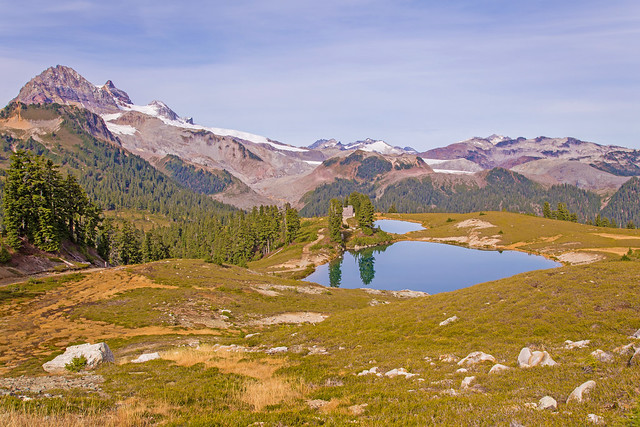
Elfin Lakes, 2 Oct 2016
Andy G. at Elfin Lakes:
“Well I wanted a smaller group to return to Elfin Lakes 12 years after my first Wanderung hike, and I got it! Louise, Susan, and Gloria decided to brave the so-so weather forecast, which changed at the last minute to give us mostly sunny skies for the day. Garibaldi gleamed white in its dusting of snow from the day before, and the lakes were often still enough to yield perfect mountain reflections. We enjoyed a sunny lunch at a picnic table by the cook shelter rather than eating on the tent pads (which the other groups seemed to think was OK – a good opportunity to discuss some Leave No Trace principles). The shelter was empty and every bunk now has a ‘reserved’ label on it.
The trail was quite busy – the parking lot was pretty full when we arrived – many of whom were backpackers on their way out. The hikers’ trail out of Red Heather meadows is being upgraded and is currently a bit of a sticky, slippery mud-fest. One of the backpackers on their way out slipped and ended up plastered from head to toe. We stayed on the main trail on our descent which meant keeping our eyes and ears open for mountain bikers (there were quite a few).
The meadows have plenty of great fall colour but precious few berries. Our only wildlife sightings were a falcon and a bald eagle – not even a whisky jack or chipmunk though we heard pikas among the rocks.
Another great day out and a great way to celebrate 12 years with Wanderung!”
Watersprite Lake, 30 Aug 2016
Danica at Watersprite Lake:
“Cheryl, Susan, Xiru, and myself embarked on a journey to Watersprite Lake. Various trip reports stated that the logging road was okay for 2wd vehicles, but I’m not entirely convinced. Our driver thought it was one of the rougher logging roads she had taken her car up. We made it to around the 15-km mark before bailing, and hiked the final ~1.7 km to the trailhead. We took the old trail, as could not find detailed instructions about the new trail. The hike follows an old logging road, before turning off to a swamp. Unfortunately we got chatting too much and missed the well marked turnoff. A quick backtrack and we were on our way. We had read reports of a muddy trail, and even in late August this was true. Hopefully the new trail will avoid the mud. The lake is reached after ascending a final boulder field, and the views do not disappoint! We spent 2 hrs swimming and lounging (mostly the latter), before heading back. A total of ~19 km and ~9 hrs made for a long but very worthwhile day. A huge thank you to Cheryl for driving!”
Upper Shannon Falls, 25 Mar 2016
Bob H. at Upper Shannon Falls:
“With a forecast all week for sun for Friday, expectations were high. A little concern about 5 mins from the parking lot, when it rained slightly, but the clouds parted and we were treated with lots of sun today.
Upper Shannon Falls is the 3rd highest waterfall in British Columbia and the hike to the top is well worth it. Today, our group of six parked in the Shannon Falls parking lot, but you can also park in the parking lot for the Sea to Sky Gondola, a short distance to the north. The initial part of the trail is shared with the trail for the Stawamus Chief hike. If you park in the Shannon Falls parking lot, you can see the bottom of the falls before your ascent. The trail is well maintained by BC Parks and there a few bridges to cross. Sections of the trail are steep, with some parts having nicely placed cobbles for steps. The trail was quite busy today and there were about 30 people at the top viewpoint.
The trail rises steeply and there are a couple of viewpoints before the top. There is also a section of the falls, where you can get very close. There is also a nice pool of water in the creek, where you could go in – in the summer, but I would imagine the water is very cold all year. At the top, you are rewarded with an amazing view of the end of Howe Sound, the Stawamus Chief and Squamish. The bluff at the top is a large area and accommodates several people.
Overall, the day turned out perfect and the group really enjoyed the hike.
Blog post here: http://www.buntzenlake.ca/upper-shannon-falls/
Full Flickr photo album of hike here: https://flic.kr/s/aHsktHWSzp“
Mt Mulligan, 11 Nov 2015
Chris M. on Mt Mulligan:
“We chose Mt. Mulligan for a Remembrance Day walk in the fresh snow. We were able to drive up fairly high. The road we followed gradually grew in snow coverage and reached a foot deep by the bowl where the road ends. We observed a minute of silence here. Leaving the road, we went directly at the col between the two peaks of Mulligan (one of them is sometimes called Anif). It was enjoyable finding a way through the underbrush that wasn’t completely covered by the snow yet. Then we turned right and made our way up the south peak. Some of us used microspikes but no one used snowshoes. As we reached the summit the clouds pulled back a little to reveal most of the beautiful Sky Pilot Group. The return back down was very simple. Hiking time was 2.5 hours up and 1.5 hours down. A nice early dinner at Howe Sound Brew Pub suited the fun group of Amy, Anna, Nicole, Estafan, Tom & Danielle.”
Alpen Mountain, 8 Nov 2015
Chris N. on Alpen Mountain:
“The road up Alpen was a good lesson in the need for good maps. I had always relied upon the excellent 1:20000 maps that iMapBC creates but it turns out that, for the Alpen region, they were missing some recent and important side roads. It was better to use satellite images from Google Earth which showed all the major forks. Armed with maps of several varieties and altimeters, we managed to push our convoy of AWDs and a 4wd to a major fork at 1350 m elevation (about 7.5 km up the Alpen spur). The waterbars in the last 1.5 km caused some scraping for the lower clearance vehicles. A good 2wd driver should be able to make it to about 6 km assuming decent traction. It was a mild bushwhack east and then south towards Alpen. The final push was up a steep slope from the west. From here, we stuck to the ridge running south towards Split. We sidehilled for a bit around Split before again heading straight up the western slopes to the lumpy summit. We didn’t find much in the way of vents mentioned by others but a northern vantage of the peak shows large broken pinnacles as if some giant had taken an axe to the summit. We followed our track back over Alpen to the cars. The whole hike had taken just over 5 hours.”
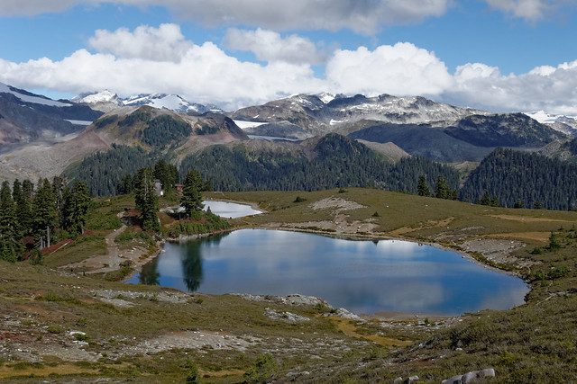
Elfin Lakes, 15 Oct 2015
Bob H. at Elfin Lakes:
“Today was a gorgeous early Autumn day for a hike. Elfin Lakes is in Garibaldi Provincial Park, located just north of the town of Squamish. The first 6 km of the hike are uphill, 4.5 km of which are on a forest service road. There is a small section where the trail is more rugged and muddy, but then it starts again as a wide established trail. As you continue, the views get spectacular; you see Mount Garibaldi and the surrounding peaks. At the Elfin Lakes campsite (also known as the Diamond Head Area), there are two lakes, one for drinking water and one for swimming; there is also a ranger’s hut, a camper’s hut, a small dining building, tent pads and picnic tables. We made it to the lakes in 2 hours 20 mins, but didn’t have any prior plans for additional exploration, so we headed towards Opal Cone, which is about 6.5 km from the lakes. After crossing the new bridge over Ring Creek, the valley to Opal Cone is mostly a rugged rock landscape and today it was quite warm with the sun beating down. We ended up about 1.5 km and 300 m elevation short of Opal Cone – we had to turn back due to the early sunset – so close!!! Will have to plan this next year! We did a distance of 30 km today with 1500 m elevation gain in 8 hours.
Blog here… http://www.buntzenlake.ca/elfin-lakes/
Skyline Ridge, 7 Sep 2015
Eugene Y. on Skyline Ridge:
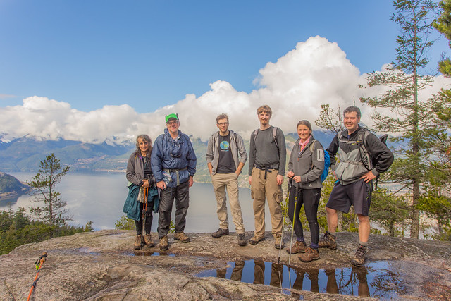
“This ridge is easily accessible from the Sea-to-Sky Gondola, however, we wanted to hike up all the way from the parking lot. The Sea-to-Summit trail was mildly crowded on this fine Labour Day, nevertheless, once we turned to the Shannon Basin trail, the crowd vanished.
The initial portion of the Skyline ridge trail is not too inspiring, as it follows a logging road for the first 2.5 km. Thankfully, the trail becomes really enjoyable once it leaves the road. It took us under 4 hours to get from the parking lot to the end of the “official” trail (~1200 m elevation), and then we proceeded for another hour through a pleasant forest along a less-marked trail till we finally reached a plateau at the junction of the Skyline and Goat Ridges. Now it was picture time!
On the way back, it took us about 2.5 hours to hike down to the Summit Plaza. That left us plenty of time for a quick beer on the deck before taking the gondola down.
Some stats: elevation gain ~1600 m, total distance: ~23 km.
Overall, the Skyline Ridge is a wonderful destination for a day hike. The trail is gentle with practically no scramble, and the views are truly magnificent.”
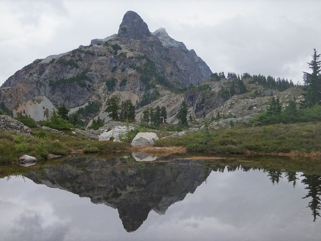
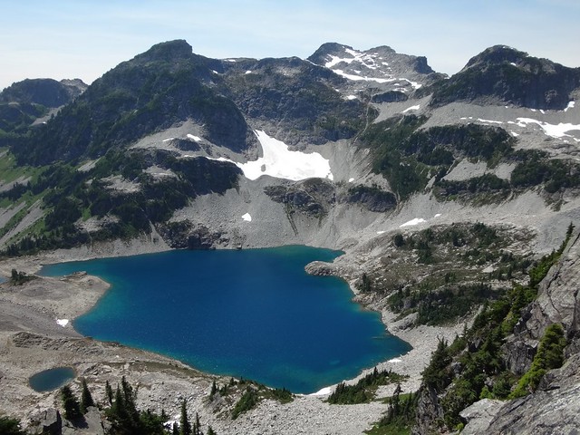
Tricouni Meadows East, 4 Jul 2015
Eugene Y. at Tricouni Meadows East:
“The Chance Creek FSR was in a pretty good condition and reasonably well marked with red bands at all the major intersections. With an OpenStreetMap, we had no difficulties navigating the road. My Protege easily made it to the 8.4 km mark (1050 m elevation). TJ drove his Outback for another 500 m. We walked the remaining 2 km of the road all the way to the trailhead.
The trail was in a very good condition and mostly dry. After a 30 min walk through a pleasant forest we reached the blooming meadows about 800 m south of a large glacier-fed lake at the head of the High Falls Creek (1500 m elevation). At this point we split, as some of us went directly to the lake, while others ventured to explore the ridge on the east side of the lake.
Our route to the ridge involved some light bushwhacking, crossing a boulder field, and climbing a dry stream bed. Finally we reached a narrow plateau (1700 m elevation) that offered superb views of Tricouni, Garibaldi, and the surrounding areas. As we were running out of time, we decided against proceeding further along the ridge.
Once we descended to the lake, we joined the rest of the group for a pleasant swim. The lake itself proved to be a bit too cold, however, the large tarn on the east side was truly enjoyable.”
Alice Lake, 17 May 2015
Nancy L. at Alice Lake:
“A fabulous group of hikers enjoyed a hike in the Alice Lake area last Sunday. The weather was perfect, not too hot & not too cold. We visited 4 lakes and also climbed up Debeck Hill to see the view. It was a lovely outing shared with a great bunch of people.”