Su-Laine at Gambier Lake:
“I’m casting a dissenting vote amongst the accolades for Gambier Lake. This may be one for a hot day when you just want to be in the trees, as the trail is all through second-growth forest. There are no viewpoints and we saw little wildlife. I guess what makes this trip special is the ferries and the feeling of remoteness on Gambier Island. The trail was snow-free and dry except for big mud patches near the lake.”
Category Archives: Day hike
Bear Mountain 23/05/09
Steve on Bear Mountain:
“Three cars, 9 hikers, 123 km there, 2 GPS, 21 degrees, 0 wrong turns, 1 viewpoint, 1 pair lost sunglasses, 18 km hiking, 1 km on snow, 2 much windfall, 1 froggy pond, 1 amazing lunch spot overlooking the Fraser valley and the Cheam range, 2 borrowed insoles, 1 pair found sunglasses, 1 brown bear sighting, 1 swim in lake, 1 huge $%&* burger at the Wildcat Grill, 123 km driven home, 9 happy hikers.”
Baden-Powell Trail 18/05/09
Heather on the Baden-Powell trail:
“Seven of us decided to tackle the eastern half of the Baden Powell trail. We took the bus bright and early to Deep Cove and huffed and puffed our way up the first section to the great lookout over Indian Arm. From there is was a varied ramble across lower Seymour Mtn, enjoying the forest, crossing creeks, being in awe of the numerous trail runners and mountain bikers passing us by. After the first 13 km section, and battling our way through the tourist mobs at Lynn Canyon, we took a leisurely lunch at the coffee shop, where two of the group decided that was far enough and bussed home. The five remaining continued another 11 km to the base of Grouse Mountain, stopping to chat with other hikers and at the surprise discovery of a couch on the middle of the trail. This photo op also led to the discovery that one of the cameras had stayed at the coffee shop, but with the help of cell phones for internet surfing (while couch surfing), all was eventually restored to proper order. Total trip was nine hours long – a pleasant hike with great company!”
Mt Hallowell 17/05/09
Erez in search of Mt Hallowell:
“Do and me attempted to hike to the summit. We came close. Seeing the summit from a distance, but unfortunately, we didn’t manage to find the last part of the trail to get us there. The description in 103 Hikes is pretty accurate. We parked a few hundred meters along the very rough road. We hiked past the first large washout gaining elevation pretty quickly. The first junction mentioned in 103 Hikes was actually at 894 m according to my GPS right after a pretty high waterfall. The T-junction afterwards was at 926 m. After that junction the road was covered in deep snow. We found the trail. No cairn or red spool but quite a lot of orange flag tape made it hard to miss. Initially the trail is marked very well, but just before the clear cut the flagging tape dwindles and dies away (or maybe it was hidden under the snow). We spent almost an hour looking for the trail, and eventually had to give up. We had a good surprise on the way back – the ferries ticket are round-trip, so the cost was half of what we expected.
Here are UTM coordinates of some waypoints:
1. Start of “deteriorating road” either park here or go as far as you can: 10U
0430941 5501287
2. “930 m elevation junction according to 103 Hikes” (elevation was actually 894 m): 10U 0432223 5503187
3. T junction: 10U 0432418 5503055
4. Start of trail to peak: 10U 0433055 5504018
I’d very much like to try it again – maybe when there is less snow.”
Mt Sproatt 16/05/09
Ahmad on Mt Sproatt:
“We were lucky in many ways of how our hike turned out. We headed first to Whistler Olympic Park. I was surprised by how little snow existed there at altitude 850 m. The forest looked too thick to be bushwhacked and the snow conditions looked bleak. We headed then to an abandoned gold mine which I thought would be better approach as it was located at 1000 m and it was on a more direct route. We parked at about 960 m where the snow line started. We were then pleasantly surprised to find a road that took us all the way up to the ridge (it is possible that this is drivable to about altitude 1250 m in summer. I also think that this road is used by snowmobiles in winter). Soft and slushy snow on the ridge took a big toll of energy from us. It was not sunny but it was definitely a hot day. We got to 1 km away from the peak at altitude 1720 m but we then decided that it was not really worth it to complete the hike. Instead we headed to a false summit at 1750 m and we called it a day. I am very sure that we could have made it.”
Sunset Trail 16/05/09
Steve on the Sunset Trail:
“Seven of us embarked upon what was a much steeper trail than I had anticipated from Sunset Marina. Our group had a very compatible pace so we managed to cut through distance to the 850 m mark quickly despite a significant amount of windfall (but someone with a chainsaw had fixed most). However, at that point we hit snow, but it was not difficult to walk on it in boots. We did, however, lose the trail near the loop at the top and were not 100% sure we made it to the right viewpoint, and at least 1 km of our journey was off-trail but we did manage to pick it up on the way back.
Given the dismal weather report, this turned out to be a good trip, with a great group, but I’d wait until June before trying this trail. And lastly, the famed Sundowner pub is no longer. The former best location in West Van is now the home of a crabby caretaker for the marina that does not welcome you with open arms.”
Alouette Mountain 15/05/09
Robert C. on the Alouette Mountain trail:
“Alouette Mountain is located in Golden Ears Provincial Park near Maple Ridge. On the Friday before the Victoria Day long weekend, seven of us headed out on the trail to Alouette Mountain which provides an endless panoramic view of neighbouring mountains and other landmarks. Without snowshoes, our goal was to hike to the snowline but we were motivated to reach the summit after realizing the snow was relatively easy to walk on. It was a challenge physically, especially to do a hike that is even considered long in the summer (22 km return) with an elevation gain of 1100 m and a peak elevation of 1366 m. This trail has lots of variety winding through forests and an old logging road. This hike was a great example of teamwork as each played a role in navigating as we tried to view the tree markers, some of which were buried under the snow. After about 4.5 hours hiking through the snow we saw the famous Blanshard Needle that towers over the mountain. There are great views of Golden Ears Peak, Edge Peak, Evans Peak, Robie Reid, Alouette Lake, and more. After about an hour on the peak, we headed back down to reach the trail head 2.5 hours later. I would recommend this trail to anyone who likes to snowshoe in the spring, and also to those who like beautiful views from the summit.”
Cheakamus Canyon 09/05/09
Susie at Cheakamus Canyon:
“Susie, Angela, Louise and Noman met on a gorgeous Saturday morning for this very enjoyable hike. With Highway 99 open through the contentious Eagle Bluffs, travel to Squamish is now fast and easy. We drove to the end of the road in Paradise Valley (we had a 4×4, but saw 4x2s at the parking spot), and started up the trail to cross the BC Rail line. That dealt with most of the (minimal) elevation gain, and soon we were at Starvation Lake, very pretty on a sunny morning with a couple of Canada geese posing in the middle. Shortly after we entered the canyon area, via an exciting piece of trail where you are literally walking on air … fortunately over some sturdy netting securely fastened to the cliff. The sound of the Cheakamus River pounding through the canyon was with us for the rest of our trip. It is impressive looking down at the railway line below and marvelling at the engineering required to build it. The trail must pass through a rain shadow, because the vegetation is more reminiscent of the Interior than coastal rain forest. The trail eventually peters out at Highway 99, so we turned around before the traffic noise was too great. A lovely relaxing hike, although we agreed it probably should be classified as a “wike” (walk/hike). It’s worth noting that this trail is snow free 99% of the year.”
Levette Lake 09/05/09
Chris on the Skyline and Copperbush Trails near Levette Lake:
“Cara, Ivy, Jennifer, Susan, and Tao joined me on a leisurely ramble around the Skyline/Copperbush trails with a sidetrip to Levette Lake. Don’t believe the bad reports for this trail that you might read on the Internet. Granted, if you plan on going in a clockwise direction, the start of the trail is tricky to find and looks a bit overgrown but it’s fine after 100 m – just watch for the painted can lids nailed to trees. The lookouts have grown in a bit (like at Diez Vistas) but the views are still great (Tantalus in your face) and the trail is quiet. Levette Lake is popular and we encountered a large car-camping group up there. Hanging out at the lake is a bit cooler than at the bluffs (like Silver Summit) to the south.”
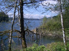
Hayward Lake 09/05/09
Paula on the Hayward Lake trail:
“We couldn’t have wished for better weather for this hike. The group of eight were ready to embrace the day with good cheer. Initially missing the turnoff to get us on to Dewdney Trunk Road, we soon realised our mistake, it added extra travel time to reach the trail head but otherwise would be less than an hour from our meeting place at Safeway at Broadway & Commercial.
It is a well marked and maintained trail, much like Buntzen Lake but almost twice the distance. The old railway trestle bridges half emerged in the water provide an interesting backdrop for photographs as does the forest with moss covered trees, ferns etc. The Steelhead Falls was spectacular this time of year, running fast and furious, we stopped to take photos and snack at the base. Whilst we did pass a few small groups of hikers in the afternoon, it was relatively quiet on the trail. Back where we started we relaxed in the sun and contemplated taking a swim from the sandy beach.
Whilst there is not a lot of elevation the upsy/downsy trail and the 16/17 km length does provide a good workout and trail time was 4.5 hrs including our rest stops.”