
Chris N. on Mt Seymour:
“Snow was somewhat wet and heavy almost all the way to the first peak. If you stuck to the trail, snowshoes were probably not needed (but you would posthole off trail). Given the amount of snow lower down, I had expected more higher up but it may have been due to wind scour. Around the peak, there was a stiff wind crust and small pockets of wind-deposited powder. Many trees were bending under a load of crusty, icy snow and snowbombs were frequent (and dangerous as they were large and icy). Surprisingly, trail traffic was relatively light for a snowy weekend. Temperatures were warm with a slight inversion – slightly above freezing at the peak and warmer than the city at the parking lot. Visibility was outstanding but flurries moved in while we were on the peak. This became rain as we descended below Brockton Point.”
Tag Archives: North Vancouver
Kennedy Falls, 2 Apr 2016
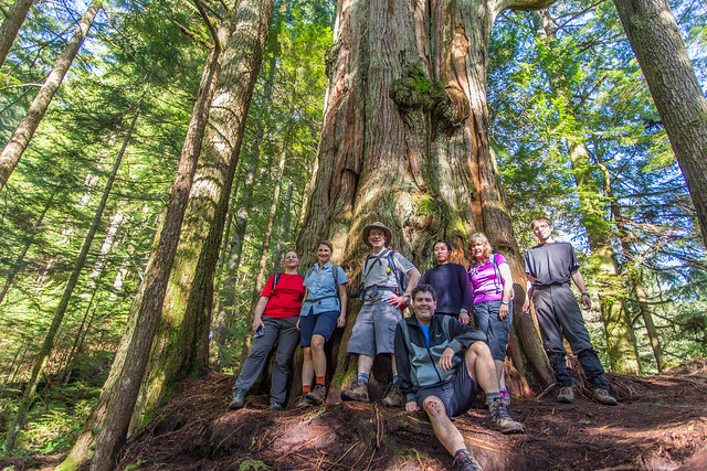
Bob H. at Kennedy Falls:
“This is a great hike with two points of interest. First, is the big cedar tree, which has been estimated at over 600 years old; the second is Kennedy Falls. Don’t let the length and elevation gain of 170 m fool you for this hike. There are many ups and downs on this trail making the cumulative elevation gain 750 m. The length of the trail is 5 km, so the return total is 10 km. The trail traverses the west slope of Lynn Valley and you will find the big cedar tree 3.3 km from the start; also of note – the big cedar tree is less than 100 m from Lynn Creek. The cedar tree is massive and the only reason I think why it was spared from the saw in the early 1900s, when the whole area was logged, is that there was no saw large enough! The end of the trail marks Kennedy Falls, which is spectacular and fills the air with wind, mist and rainbows. There is a new parking lot at the trailhead on Mountain Highway, which fills up fast, so get there early. This is a very popular mountain biking area.
Blog post here: http://www.buntzenlake.ca/big-cedar-trail-and-kennedy-falls
Full Flickr photo album of hike here: https://flic.kr/s/aHskxGD5Pg“
Kennedy Falls, 12 Mar 2016
Paul G. at Kennedy Falls:
“A wet day with a little hail thrown in for effect, but a nice hike regardless. Trail conditions this time of year are slightly muddy, but even with our recent rainy weather, no one seemed to have trouble with the stream crossings. There were a few downed trees, but easy to get around. If you are not familiar with the route, keep your eyes on the few markers. It’s easy to get down a dead end when you are deep in conversation. Besides the beautiful big cedar, Kennedy Falls at the end of the trail was spectacular. For a trail that was relatively unknown a few years ago, it was busy with trail runners early on and hikers later. Popularity due in part by the addition of the new parking lot last year.”

Mt Seymour, 20 Feb 2016
Chris N. on Mt Seymour:
“The weather was exactly as predicted but the snow conditions were better than I had anticipated. We arrived at the Mt Seymour parking area about 10 am and parked across from the tubing area. The temperature was about freezing and we were treated to about 1/2 hour of light ice pellets before the precipitation stopped. There’s about 1 m of snow at the parking area but over 2 m less than 1 km up the trail. The snow below Brockton Point was heavy and sticky but much nicer past this point. Snowshoes would be advised beyond Brockton Point to prevent postholing. Avalanche conditions were listed as moderate below treeline and considerable at treeline. It was quite foggy at Pump Peak with visibility dipping to about 50 m at times and very flat light. After a lunch stop, we continued on to Second Peak following some ski tracks to the base of the gulley (no snowshoers had ventured further than the first peak that day). The ice pellets rolled underfoot and slowed our accent. The sun peeked out on our descent and provided some really nice lighting.”
Lower Mt Fromme trails, 13 Feb 2016
Chris N. exploring the lower Mt Fromme trail network:
“The trail system on Fromme is a true rabbit warren. Even with 2 sets of detailed maps, it often took time to figure out where we were. Besides named trails, there are many minor trails. Signs are infrequent and only on the Baden Powell and Mountain Highway. We started at an unsigned trailhead beneath the power lines at Braemar Road. If you are driving, there is good street parking on the north side of the road here. Otherwise, the 230 bus travels this road. We hiked up Dreamweaver almost as far as the crossing over Mosquito Creek. We then backtracked a bit to Peer Gynt (unsigned) and climbed to the Mountain Highway which we hiked down until we got to Pink Starfish. This is a double-black bike trail but it doesn’t seem to get much traffic these days. We actually lost the trail about halfway down and followed a minor trail down to an old skid road. Going east on the road for a bit, we found Pink Starfish again. We continued east as far as Espresso which we followed to St Mary’s trail. Back along St Mary’s to Boundary and this we followed until we came out at our trailhead again. We found two old cabins on our explorations but both are in the last stages of collapse.”
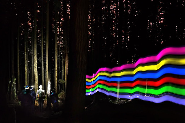
Baden-Powell Trail, 11 Dec 2015
Chris M. on the Baden-Powell Trail, at night:
“If night-hiking was an Olympic event, then I would nominate the fearless group that joined me Friday evening. Nicole, Nima, Ronja, Tu Loan, Jon & Meghan all sailed through 3 hours of dark North Shore trail wandering; aided by nothing more than headlamps. Oh, and a rainbow-coloured glowing hiking pole. I took a right fork that turned out to be a wrong fork, so we ended up mostly doing an out and back along the Baden-Powell. It was a neat way to end a work week.”
Kennedy Falls, 7 Nov 2015
Stephen H. on lower Mount Fromme:
“It was the day of the Wanderung party – you know, the one with a rainfall warning – so we were guaranteed to get a little wet. Still, we had a good turnout, with Renee, Marlis, Svetlana, Shahdin, and John committed to getting outside regardless of the weather. The plan was to hike to Kennedy Falls, but a raging creek soon put that off to another day. We ended up doing a foggy forest loop via four mountain-bike trails and the old Mountain Highway. There was water flowing everywhere. Note for next time: the parking lot at the top of Mountain Highway opens at 9 am.”
Mt Bishop, 23 Sep 2015
Tamara S. on Mt Bishop:
“This was a bike & hike trip into the Seymour Valley up to Mt Bishop at 1509 m. We, a group of 4 hikers, set out with our bikes from the gazebo at the entrance of Seymour Valley Trailway at 8.30 am and pedaled all the way back to the dam on the paved road. Up over the Bear Bridges, a bit uphill and on to the Mt Bishop trail. It took us one hour to cycle in. The first part of the trail is pretty steep with a lot of ropes for help. On a wetter day the downhill could get quite tricky here as the trail is very muddy and slippery. At the lakes, half-way up, one of the hikers decided to descend again to return to the city and 3 of us continued to the peak. Just below the peak on the rock field it is not immediately clear where the peak is but it becomes clearer as you get up over a little gully with a view to the peak. It is a bit of a scramble at the top where you have a beautiful 360 degree view. Lots of water on the way up to refill water bottles. We were back at the gazebo at around 6.15ish quite tired, with some scratches, bruises and dirty pants.
Advice: good shoes, it can be very wet at the lakes and muddy on the first section.”

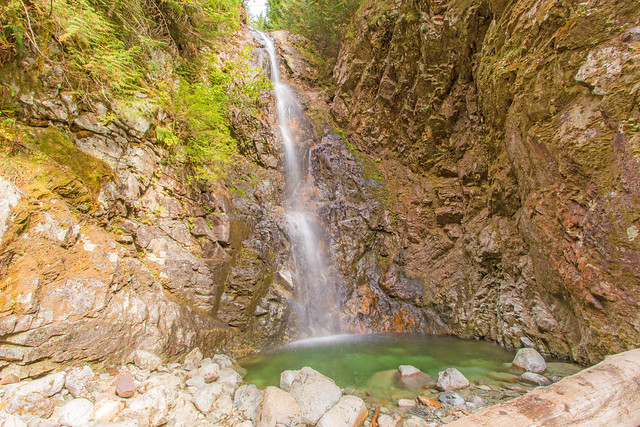
Norvan Falls, 26 Aug 2015
Bob H. at Norvan Falls:
“A nice 7 km hike up Lynn Valley on gentle sloping ground will get you to the beautiful Norvan Falls. Norvan Falls is one of Greater Vancouver’s secluded gems; it’s a 30 foot high waterfall set in the depths of the north shore forest. For a little extra workout (which I did today), there is a 2 km parallel side trail that takes you into a more rugged path, 100 m higher than the river path. Alternatively, you can follow the river on a more flat route. When I arrived at the park, there was no space in the 1st or 2nd parking lots, so my trip was 600 m x2 longer. The hike starts at Lynn Headwaters Regional Park in North Vancouver.
Blog, with stats and photos here: http://www.buntzenlake.ca/norvan-falls/”
Norvan Falls, 9 Apr 2015
Andy G. at Norvan Falls:
“This hike was the very first trip I organized through Wanderung in April 2005 and I could not resist re-organizing the same hike a decade later, almost to the day 🙂 Thanks to Gary signing up, I was able to get out and celebrate that anniversary.
It was another sunny day in Lynn Headwaters, and the falls made a nice destination. The sunshine in the forest was very cheery, and despite cool temperatures (we needed gloves after a few minutes hanging round at the falls), spring is definitely here. Skunk cabbage is blooming all over the place, salmonberry too. Yellow stream violets are abundant along the trail by Lynn Creek, spring beauty is out here and there, bleeding heart foliage is out but only a few flowers just now. And the birds are singing: wrens, varied thrushes, the occasional hummingbird and others I can’t yet identify.
The trail was remarkably dry, which made travel easy and fast: our hike time was 4.5 hours including a couple of snack stops. There were only a few muddy and slippery patches up in the forest between the Lynn Loop turnoff and the third debris chute. The water level was quite low in Norvan Creek which made it easy to get down by the water for some nice waterfall shots.”
