Category Archives: Day hike

Garibaldi Lake 01/07/09

Pablo at Garibaldi Lake:
“What a better place to celebrate Canada day than Garibaldi Lake. It was a perfect day for this hike, perfectly clear sky, not too hot, and a holiday on a Wednesday, so not many people. After hiking most of the time on snow last weekend on Elfin Lakes in the same park, I was expecting at least patches, but the trial is completely clear. We did the hike in less than 3 hours one way, including pictures, and we took a long time on the lake. A couple of us even had a swim on the lake. The level of the water is very low. After the hike we changed the dinner place in Squamish, and we even got 50% Wednesday Special with a great view of Shannon Falls (also with not much water).”

Happy Canada Day

Musical Bumps 28/06/09

Ahmad on the Musical Bumps:
“Everything is beautiful on Musical Bumps. The peaks, the glaciers, even the clouds look more beautiful there. The level of snow is much less this year. There are only snow patches and the biggest one was about 50 m in diameter. The trails were in good condition. The bridge over Harmony Creek doesn’t exist but there are logs. Slippery but not too much. The area before the bridge seemed it is frequented by bears. We saw a mother and its cub just before the trailhead. It might get confusing when you get over Harmony Ridge. Go along the ridge rather than crossing it prematurely. The grade will get gentle then. We got to Roundhouse at 7 pm and took the gondola down free. The whole trip took 9:30 in an easy pace.”

Elk-Thurston 28/06/09

Beth on Elk-Thurston:
“Astrid, Bahman, LJ, Geoff and I hiked Elk-Thurston Mountain on Sunday. It started with a pleasant hike through the forest which lead us to a ridge walk from Elk to Thurston. Along the ridge the meadows were beautiful, in bloom with Indian paintbrush, lupine, tiger lilies, glacier lilies and more! We had great views of surrounding peaks of the Chilliwack area and the Cascades, though Mt. Baker was hiding under clouds. This is a great hike! The trail was virtually snow-free and in good condition, with only the occasional small snow patch at the top which did not cause any difficulty. We could see that there was more snow on the north-facing side of the mountain. The day was topped off with a drive over the new Golden Ears bridge (very bumpy, yet majestic), and a bite to eat.”

Hollyburn Ridge 27/06/09

Michelle in the Cypress Bowl and Hollyburn area:
“What of Cypress in summer bloom? June has no bloom, only promises of buds and burgeoning bugs. June has no bloom, but is cloaked in lush green growth and North Shore forest. June has no bloom, but don’t let it take the bloom off Cypress, don’t bid it adieu! Cypress disrobed may have a bad case of ‘ugly naked’. But give it a few weeks and bald and bare will give way to a Friar Tuck or long stranded comb-over of speckled colour on your summer or fall trek through the area. En-route to more distant peaks or passing by to discover lily pad tarns once covered by snow. A rooty/rocky but not completely without charm section of the BP does Cypress contain, indeed indeed. Short patches of snow trundled underfoot under canopy, but easily so. And by two weeks time no more.”

Elfin Lakes 27/06/09

Pablo unwilling to let go of winter at Elfin Lakes:
“My goal for this trip was to build a snowman, so 4 of us headed to elfin lakes to build it. As I posted in the call out, there is a lot of snow on the trail. Snow starts where the hike and bike trials merge, about 1 km passing the campground. We did many parts of the trial leaving a distance of 10-20 m between each other, just in case. We saw a lot of people turning around because they didn’t have proper shoes. This part of the park is where the bears are, we didn’t meet any but we saw lots of traces of them (with bells and smell like pepper spray) in the lower parts. As usual, we ended this hike having dinner in Squamish.”

Sigurd Creek 27/06/09

Steve following Sigurd Creek:
“I hiked with Ming, Dennis, Chad, and Jessica to the knoll on the Sigurd Creek trail near Squamish. On 2 attempts in previous years I got no further than Crooked Falls in May due to snow. This time, no problem due to snow or windfall. That being said, the trail was a bit buggy, and quite steep. Despite a more open view from the knoll, and more broad look at the huge cascading falls, the Crooked Falls viewpoint at the mid-point remained the highlight. This has to be one of the best falls viewpoints I’ve been to in the Lower Mainland, partially because you can get right next to them. Note that the logging road forces you to check in at a construction station, and the construction site saw fit to sign a short-cut for the trail: ignore it and follow the usual trail descriptions (we used 103 Hikes)”

Crooked Falls

Tszil Peak 21/06/09

Ahmad on Tszil Peak:
“A nineteen-hour trip and 10:40 hours on the trail. I can tell you confidently it was a long day. My initial perception that the Joffre Lakes trail was a piece of cake but I found it fairly hard and it was not the quality that I thought – many roots, rocks, and boulders. We got to the bridge that leads to Joffre Campground after 2:20 hours where we had our 1/2 lunch break. All lakes were unfrozen. The trail was also clear from any snow. I was pleased to see Tszil has a trail. I also found it in a better conditions that the Lake trail although it is not well defined as the other one. I don’t think it goes all the way to the summit. The trail eventually climbs on a narrow ridge that was about 100 m high and in some portions was less than 1 foot wide. We got to Tszil-Taylor col at 4 pm. We still had 230 m of elevation gain to do. It was a whiteout. A large part of the slope was still covered by snow. We decided to give it a try. It was not easy. Some rocks were slippery and some of the snow was not in good conditions. We summitted at about 4:55 pm. On the way back, we chose the gully with the snowfield. It was quicker and more fun. This is my second time of taking my snowshoes on a tour without using them.”

Slesse Memorial 20/06/09

Susie at the Slesse Memorial:
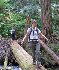
“Susie, Paula, Astrid, Marcelo and Maria met at Edmonds at 8 am, and were parked at the old trailhead just before 10 after 4×4-ing up the Nesakwatch Creek road. Some 2WD drive vehicles had made it about 2 km up the road, but then been stopped by a rough stretch. We hiked 10 minutes up the logging road to the new trailhead, and discovered that this stretch of road is also driveable now. The recent logging in the area is probably why the road has been fixed. We were happy to get on the trail proper, and soon found ourselves at the somewhat scary creek crossing. As Maria observed once she was on the other side, it was an exercise in conquering fear. Now we were into some really beautiful old growth forest and we all exclaimed at the softness of the trail underfoot. We joined the original trail and hiked on up at a very gentle grade. Unfortunately cloud obscured what is usually a stunning view over to Mount Rexford and the Illusion Peaks. The odd bit of drizzle fell, but we were getting wetter from the foliage on the trail than from the sky. We lunched at the memorial site with dramatic views into the Slesse Cirque, waterfalls pouring down all around the bowl and a chilly breeze blowing off the glaciers. We decided to head on to the propeller cairn, and the trail changed dramatically from a very ancient logging road to a scramble through very wet encroaching blueberry bushes. Must be bear heaven in late summer. We started to run into snow as we reached the top of the ridge, and were eventually turned back by a snow bridge that clearly wasn’t going to bear our weight. However we were now looking down into the Slesse cirque from above, and were satisfied with our destination. We were back in Burnaby just before 6, having all enjoyed our day very much. This is a great hike.”

P1030864

Mt Fromme 20/06/09

Peter B. on Mt Fromme:
“Four hikers – Eileen, Kristie, Jana and Peter – started hiking up Mosquito Creek (rough in parts) and in a combined effort found their way through the maze of old logging roads, trails and downhill tracks up to the south summit of Mt Fromme where we had good views of Lynn Valley and the surrounding mountains. We encountered patches of snow and almost no other people. Instead of returning the same way, we walked (and got a lift) up the Old Grouse Mountain Highway and enjoyed the obligatory nacho bowl in the chalet before taking the gondola down.”

Eaton Lake 20/06/09

Steve at Eaton Lake:
“Five of us did the drive to Hope following Andrew’s clear report from last week. Despite the 16+ km on a gravel road, I feel even a low rider car would have had no problem. The bridge replacement “logs” weren’t too bad but if it had been more wet, I think it could have been a problem. The lake scenic, and worth the trip, but I could see how people might want to do more than make it to the lake (Matt Gunn’s book shows surrounding scramble routes). What was a shocker was how cold the end point of this trip was. At the lake we scrambled to put on every item of clothing we had. It was a true reminder of how even in the heat of Summer, you can get surprised by a cold snap at altitude. Watch for bold birds also. A good trip maybe worth doing if you are already out this way, but the company made up for the drive time. And in case you are wondering… a barrel is held together with a hoop!”

Beth balancing on the log.