
Heather at Garibaldi Provincial Park:
Tyler, Ted, Bob and Heather did an overnight trip in Garibaldi park. We took Saturday to hike into Cheakamus Lake, have lunch and a quick dip, and then start the ascent up the slopes toward Helm Valley. As we had some extra time, we decided it might be nice to try and find Corrie Lake, which was estimated at 1/2 km off the trail (a beautiful blue lake that can be seen from the peak of Whistler). We made it, but the hour and a half of bushwhacking and the unbelievable mosquito clouds would not convince us to do it again! (We decided we were training for Chris Nott’s call-outs…) Camping at Helm Creek was beautiful but another incredible battle with mosquitos – full-on gore-tex and mosquito nets only slightly delayed our escape into the safety of the tents. Sunday was a scenic 25 km hike up the scenic Helm Valley to Panorama Ridge – incredible views of Black Tusk, interesting cinder cones & valley floor, stunning colours of Garibaldi Lake and all the surrounding glaciers and mountains, and the most vibrant wildflowers blooming everywhere. A quick dip in Helm Lake was a refreshing stop on the long hike back to the car.
Category Archives: Day hike
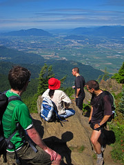
Whistler 18/07/09
Pablo at base-camp Whistler:
“7 of us went to Whistler Friday Night for 2 days of hiking. It’s nice to have a base camp on Whistler. I woke up late and I found my breakfast served. We started hiking Singing Pass at around 9:30am and we just make it on time to take the last Peak to Peak Gondola forth and Back, we even got the silver one back from Blackcomb. We went down to the village, went shopping, and then we went to the beach for a swim, and after we had a BBQ dinner before they closed the Village Gondola at 8:30pm. Thanks Mike for cooking. Some of us even did a small night hike to the village nightlife before going to bed for the next hike Sunday to Joffre Lakes.
Singing Pass-Musical Bumps took us 7 hours including lunch and time for taking 599 pictures. The snow is almost gone. We didn’t see any bears but we found several Marmots instead. We did Joffre Lakes in a more moderate pace. The Glacier is melting fast and going too close is getting dangerous because of the ice falls. Lots of mosquitoes and bugs.”
Rainbow Lake 18/07/09
Su-Laine at Rainbow Lake:
“It’s a great hike and now is a great time of year to do it. The trail was completely snow-free, and dry for most of the way. This trail is known to be muddy in the springtime but it wasn’t an issue on this day. Some, but not all flowers were in bloom, so peak flower time should be soon. Group dynamics were another highlight of the day, with conversation ranging from world peace to Gary Coleman. Temperatures were surprisingly cool considering what a scorcher this week has been in Vancouver, and the trail wasn’t crowded at all.”
Elk-Thurston 18/07/09
Steve on Elk Mountain:
“Pros: Wildflowers! Minimal bugs. No snow. Views of the valley.
Cons: Crowds. People with dogs.
Don’t let the crowds and dogs fool you, this trail is challenging and steep in sections, though not nearly as bad as 103 Hikes would lead you to believe. It takes more like 6 hours, not 7. Make no mistake about it, July is the time to do this trail due to wildflowers, though I’ve also heard it is a great Fall destination also. Many fields had 6 or 7 types of flowers (and colours) in one eye-shot.
We really pushed the speed on the way up, but I suggest slowing down, and taking in the views. The trailhead can be accessed very easily with only maybe 0.5 km of the access road being gravel. We were behind a convoy of 7 cars from the Korean hiking club of Vancouver.
Seven of us did this Chilliwack trail on what turned out to be a sunny day and followed up with a trip to some fruit and corn stands in the area. I’m still trying to figure out why we didn’t use the drive-thru at the corn place instead of getting out!”
Mt Laughington 12/07/09
Michelle having a laugh on Mt Laughington:
“Fact: GPS invaluable for getting you to and on trail smoothly (GPS is the way to go on this one). Fact: steep and loose rock logging road = 4WD required (though very few water bars or bad ruts/gaps = minimal clearance issues). Fact: trail is almost snow free (snow remains, but patches do not obscure path) and once on the trail proper (to the knoll), foot bed is well enough worn and well re-flagged. Fact: book time 4.5 hours? make it 5 – 5.5 (we took almost 6 with pauses and breaks). Fact: we saw Ogopogo. OK, well at least an ethereal cloud that magically formed before our eyes over Airplane Creek baring a remarkable resemblance to the spirit of Ogopogo (which then sauntered down the valley). But we did see 1 prancing dancing deer who welcomed us, 1 dodo grouse on road who played chicken with the truck, hovering humming birds at the knoll, 10 thousand wild flowers, 1 million mountains, 1 blue lightning bolt signalling the end of lunch, 2 fat football grouse, 2 thunder claps enlightening us our day pass was expiring, 1 bunny rabbit who sent us off with a good-bye upon our departure, just before the rain began.”
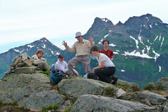
Panorama Ridge 11/07/09
Pablo on Panorama Ridge:
“Last weekend 6 of us did Panorama Ridge in one shot. It’s a long hike (30 km) with a lot of elevation gain, but it can be done starting early and keeping a good pace. This is a hike to do on a not-too-hot clear day, as we had; the view from the ridge is impressive. Not recommended for people with fear of heights. The trail is in good condition, but we had to do a little light scrambling at the top, because there are still snow patches covering the trail. The flowers are starting to appear at the meadows. I would say that probably in the next few weeks will be the best time for flowers.”
Dennett Lake 10/07/09
Carolyne on the Dennett Lake trail:
“Four early risers went to tackle Dennet Lake. After a steady climb we had a water break at Munro Lake and then pressed on. It soon became obvious that the trail hadn’t been cleared recently when we started having to go under, over and around many fallen trees. Dennett Lake was lovely when we stopped for lunch. On the map in ‘103 Hikes’, it shows a path to the west end of the lake and then two paths: one to take the ‘wet route’ down via the Village-Lake Trail, the other up to the ridge. We only saw one trail. After a steady climb we emerged about 30-45 minutes later at a junction for Harper Road. Not where we wanted to be. However, there was the consolation of the beauty of Hourglass Lake and making it almost to the summit of the ridge. We headed back to Dennett Lake. After some searching behind one of the campsites, the wet route was found. It went through a number of little water meadows. Eventually we arrived at the junction with the main trail. BEWARE: the trail map is not accurate for the wet route starting at Dennett Lake. Also worthwhile: Munro Lake lookout.”
Brothers Creek 03/07/09
Dana on the Brothers Creek trail:
“I was pleasantly surprised to get six hikers (including two drivers) on this weekday hike: Stas, John, Kathleen, Chelsey, Constance, and I. The trailhead just off Millstream Road in West Van was full of vehicles, but we passed very few people on our route. The route took us up the Brothers Creek fire road, a long gradual incline (taking in most of the elevation gain) to our first crossing of Brothers Creek. At this point we had hiked only an hour, and decided to continue right instead of left to take in a longer loop, taking us first to the pretty beer-coloured Lost Lake, and then crossing Brothers Creek via stones to Blue Gentian Lake, our lunch stop. On the east side of the lake is a nice lunch spot with picnic table. Heading south and down after lunch, we met up with Crossover Trail, headed east, and again crossed Brothers Creek. Eventually this connected with the fire road and back to our vehicles. Total trip time was spot-on four hours, including lunch, and was just under 10 km with an about 450 m elevation gain in total. I wasn’t crazy about the first hour on the fire road, as it’s full of rocks and stones and pretty wide (as a “road,” not very trail-like, of course) so next time I’d be inclined to turn off onto the Baden-Powell or another intersecting trail to make a different loop. There are a lot of options in the area for routes/loops, which is good to know for future reference. A good outing.”
Howe Sound Crest Trail 03/07/09
Heather on the Howe Sound Crest Trail:
“Suzanna, Keith, Bob and Heather did a long hike of the Howe Sound Crest Trail from Cypress Bowl to the base of The Lions and back. Unfortunately, we started late on a very hot day, and the Crest Trail is a demanding and exposed trail – so heat exposure made for an even longer day. The views were stunning and there were only a few snow patches on the trail. Due to the heat we had to re-fill water from snow melt, and I personally drank 6 litres during the almost 12 hour hike. A demanding day, but still a beautiful place to be!”
Mt Brunswick 01/07/09
Andrew L. on Mt Brunswick:
“Making it to the trailhead just past 8am, we nabbed one of the two remaining parking spots and hit the trail. The Brunswick Mountain trail is steep, easy to follow and almost snow-free. There is also very little water available past the early crossing of Magnesia Creek. We took just over four hours to reach the summit, where we had lunch accompanied by spectacular panoramic views from what is the highest of the north shore peaks. There are a few snow patches near the summit which are melting rapidly. The scrambling near and at the summit is fun, though to reach the actual summit you will have to pass some sections with moderate exposure – your head for heights may be tested. It is, incidentally, well worth carrying a personal-sized watermelon all the way up on a hot day…”