
Peter A. on Eaton Peak:
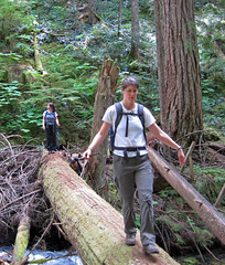
“Bahman, Michael, Eric, Thomas, Ben, Irina, Evgeny, and I tackled the tough hike and scramble up Eaton Peak’s west summit. The first 4 km of the trail is a 915 metre climb up to Eaton Lake. The trail was well-marked and generally quite wide. The 3 log “bridges” across Eaton Creek were in good shape, and because it was hot and dry, no problems with the logs being slippery. We reached the beautiful lake in approx 2 hours. From the lake, the route is a bushwhack through forest in a south-east direction to arrive at alpine just below a prominent cliff which can be seen from the lake. To start our bushwhack, we found an obvious trail behind the campsites that led uphill to a small boulder field. Across the boulder field there was a piece of flagging tape. Beyond that point, no tape was visible, and so I led our team to the east on a gradual ascent through very dense trees and bush, not wanting to cut too steeply uphill. The correct direction was to head more directly uphill (south). We eventually found Eaton Creek above the lake, and because the water flow was manageable and the rocks and moss not too slippery, we climbed up the creek to a plateau. We then followed a dry creek bed up a steep gradient and arrived at the prominent cliff face. We traversed below the face, and then climbed a steep boulder field to attain the north edge of the basin in front of Eaton Peak. Access to the west ridge was an obvious notch along the ridge. After crossing the boulder-filled basin, we scrambled up a steep ramp leading to the notch in the ridge. The start of the ridge scramble was very difficult as we crawled and climbed our way through krummholz-overgrown boulders. However, as a result, we avoided the first crux referred to in other trail reports. The second crux (the chimney) was challenging, but fun as the rock is very stable (our experienced alpinist, Bahman, assisted those who needed some suggestions for foot and hand holds. We also fixed a rope for support). Throughout the ridge ascent there were mild to moderately exposed ledges and slabs, and straddling the boulder in the “au cheval” move provided lots of laughs. The summit was beautiful, and our visibility exceptional. Baker and many other notable mountains were clear. Our time from trailhead to summit was approx. 5 hours. On our descent, after carefully down-climbing the chimney crux, we dropped down the steep gully that lies immediately to the west of the ridge and followed this almost to the notch where we had first gained the ridge. Then, during our descent of the boulder fields to the creek, we spotted a black bear feasting on berries. Thankfully, it was on the other side of the fields. We also feasted on huge blueberries and huckleberries. Since the water in the creek was relatively low, we avoided a lot of bushwhacking by descending the creek as far as we could, then bushwhacking west to the campground on Eaton Lake. We left the lake at 7:20pm, and ended up using our headlamps to arrive back at the parking lot. Total time was 11 hours. An outstanding hike with technically challenging scrambles, and a great group!”
Tag Archives: Eaton Lake
Mt Grant 07/09/09
Ahmad on Mt Grant:
“We had to turn back. I had myself no chance to continue. The fresh snow was a formidable barrier that we couldn’t pass through. I didn’t expect it and I was under-prepared for it. It was a good reminder of what frozen feet meant.
Eaton Lake trail was in good condition as it was when I did it 3 months ago. The bridges were still not repaired. The first log was wet and more slippery but doable with good care. The fork to Grant was just after the broken bridge at elevation 1300 m. We followed the south edge of the ridge. There was no trail defined. Some old ribbons and cairns from time to time till we got to altitude 1400 m. The ribbons became abundant in most places. There might be another newer trailhead closer to the third bridge.
The trail is generally bushy before the steep section. I was at the back all the time and I got soaking wet from all the water was on the leaves. The steep slope starts at 1550 m. The rocks were wet, cold, and slippery. We managed to negotiate them till we got to 1850 m.
I believe this hike would be have been a pleasant and quite scenic in good weather. I think the scramble would have been also easy.”
Eaton Lake 20/06/09
Steve at Eaton Lake:
“Five of us did the drive to Hope following Andrew’s clear report from last week. Despite the 16+ km on a gravel road, I feel even a low rider car would have had no problem. The bridge replacement “logs” weren’t too bad but if it had been more wet, I think it could have been a problem. The lake scenic, and worth the trip, but I could see how people might want to do more than make it to the lake (Matt Gunn’s book shows surrounding scramble routes). What was a shocker was how cold the end point of this trip was. At the lake we scrambled to put on every item of clothing we had. It was a true reminder of how even in the heat of Summer, you can get surprised by a cold snap at altitude. Watch for bold birds also. A good trip maybe worth doing if you are already out this way, but the company made up for the drive time. And in case you are wondering… a barrel is held together with a hoop!”
Mt Grant 24/05/09
Ahmad on Mt Grant:
“No one signed up. Nevertheless I gave it a humble try. The snow conditions didn’t look good and deteriorated quickly with the day heat. The terrain looked untamed – some ribbons but no trail. It looked too rough. I turned back on my first hard step so I cannot comment on how difficult actually it would have been. I believed it would have been some painful postholing. However, the trail to Eaton Lake was in good condition except the bridges. There were 3 broken bridges out of 4. It adds some difficulty. I also saw a couple with a dog, who refused to cross the last broken bridge. The lake was still covered by a crust of ice. There was some snow on the last 70 m of elevation. I should also say that I liked Eaton Trail. It is a forest hike but a nice one.”