
Dana on the Brothers Creek trail:
“I was pleasantly surprised to get six hikers (including two drivers) on this weekday hike: Stas, John, Kathleen, Chelsey, Constance, and I. The trailhead just off Millstream Road in West Van was full of vehicles, but we passed very few people on our route. The route took us up the Brothers Creek fire road, a long gradual incline (taking in most of the elevation gain) to our first crossing of Brothers Creek. At this point we had hiked only an hour, and decided to continue right instead of left to take in a longer loop, taking us first to the pretty beer-coloured Lost Lake, and then crossing Brothers Creek via stones to Blue Gentian Lake, our lunch stop. On the east side of the lake is a nice lunch spot with picnic table. Heading south and down after lunch, we met up with Crossover Trail, headed east, and again crossed Brothers Creek. Eventually this connected with the fire road and back to our vehicles. Total trip time was spot-on four hours, including lunch, and was just under 10 km with an about 450 m elevation gain in total. I wasn’t crazy about the first hour on the fire road, as it’s full of rocks and stones and pretty wide (as a “road,” not very trail-like, of course) so next time I’d be inclined to turn off onto the Baden-Powell or another intersecting trail to make a different loop. There are a lot of options in the area for routes/loops, which is good to know for future reference. A good outing.”
Tag Archives: North Shore
Mt Fromme 20/06/09
Peter B. on Mt Fromme:
“Four hikers – Eileen, Kristie, Jana and Peter – started hiking up Mosquito Creek (rough in parts) and in a combined effort found their way through the maze of old logging roads, trails and downhill tracks up to the south summit of Mt Fromme where we had good views of Lynn Valley and the surrounding mountains. We encountered patches of snow and almost no other people. Instead of returning the same way, we walked (and got a lift) up the Old Grouse Mountain Highway and enjoyed the obligatory nacho bowl in the chalet before taking the gondola down.”
Baden-Powell Trail 18/05/09
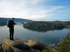
Heather on the Baden-Powell trail:
“Seven of us decided to tackle the eastern half of the Baden Powell trail. We took the bus bright and early to Deep Cove and huffed and puffed our way up the first section to the great lookout over Indian Arm. From there is was a varied ramble across lower Seymour Mtn, enjoying the forest, crossing creeks, being in awe of the numerous trail runners and mountain bikers passing us by. After the first 13 km section, and battling our way through the tourist mobs at Lynn Canyon, we took a leisurely lunch at the coffee shop, where two of the group decided that was far enough and bussed home. The five remaining continued another 11 km to the base of Grouse Mountain, stopping to chat with other hikers and at the surprise discovery of a couch on the middle of the trail. This photo op also led to the discovery that one of the cameras had stayed at the coffee shop, but with the help of cell phones for internet surfing (while couch surfing), all was eventually restored to proper order. Total trip was nine hours long – a pleasant hike with great company!”
Mt Seymour 22/04/09
Ahmad on Mt Seymour:
“The snow was hard but unpredictable in some places. There are icy sections in some places and soft ones in others. There are many path ways and the trail is only marked to Brockton Point. If you are new to Seymour or not too familiar with it, it will be hard to find the main route. I was impressed with the two people that I was with. They were new to snowshoeing and also to Seymour but their determination to summit was motivating.”
Baden-Powell Trail 22/03/09
Steve on the B-P trail between Deep Cove and Lynn Canyon:
“What a pleasant surprise! After a sunny Saturday I was wondering if I had picked the wrong day, but as it turned out, the entire weekend was great. A full load of 8 did the one-way trip starting at the east end. What shocked me was how it really was not all that muddy. We were prepared for it, but the gaiters and poles simply were not needed. Also, we may have taken a grand total of 25 steps on snow and the streams were not as high as I had expected (I wonder if this might be cause for concern in the Summer months).
Regardless, hike season without snowshoes is definitely here for those willing to stay at low elevation. This trail was chosen because it offers rain protection even on the worst days, so if you have a nice forecast, I’d suggest leaving this one for the next time it’s “iffy”.
We put up a reasonable pace with this group and had a good time meeting new people. The downside was all of the calories that we burned over 4.5 hours were replenished by ½ a donut at “Honey’s” in Deep Cove.”
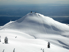
Mt Seymour 22/03/09
Chris on Mt Seymour:
“Cara, Christian, Eric, John, Ribeka and Rob joined me on a trip up Mt Seymour where snowshoes really weren’t needed (but crampons would have been good). Despite a not great forecast, the weather was stunning. On the way up, the snow was of a styrofoam consistency – pretty solid with the tiniest bit of give. The marked route takes you to within 10m of the first peak (pump, whatever you want to call it). We ventured on to the second peak. From this point, the route to the final peak requires crossing some VERY steep terrain. A couple of us decided to attempt cutting a route but most people were quite happy to sit and enjoy the view here. On the way back, we sought out every butt- and boot-skiable slope available.
The afternoon snow was pretty sloppy in places as the temperature rose and, off the beaten path, postholing became frequent. In the shade higher up, some areas had a solid crust of slick ice.”
Hollyburn Peak 26/12/08
Steve on Hollyburn:
“I admit it, I picked a really bad meeting spot. West Van has a pretty good bus system for getting people from the city to North Shore meeting spots but the parking lot I could see on Google maps was gone! Plus snow made it hard to just wait by the side of the road in a car. I strongly suggest Park Royal as a West Van meeting spot due to the bus hub, and quick access to the highway.
Thanks to Tim for the avalanche warning posted here: https://www.avalanche.ca/CAC_Bulletin_Regions. I simply would not have guessed the North Shore would have such extreme conditions. We decided to go as far as the signs and see what the rating on the trail was. There, it was rated `moderate’ and we took a heavily treed route, so we pressed on. The snow was blowing quite a bit and there were no views today, but plenty of recipe swapping and shower-curtain tobogganing. As Rich put it, any day on the mountain was better than the best day at work, and this Boxing Day was no exception.”
Dog Mountain 20/12/08
Michelle on Dog Mountain:
“The -7 / -12 with wind chill factor definitely had us wondering and we were definitely a little on the cold side starting out (our toes were already cold from just standing outside the shopping mall!). But instead of bundling up more, we quickly heated up on the trail and inevitably began the customary strip routine by the time we hit First Lake. However, after reaching our end destination we didn’t stick around to enjoy the sunny view for very long: though the winds were calm it was just too darn cold to sit around for more than a cup of tea and quick nibble. The winter route is now marked and well trodden (although a couple of alternate routes have also been stomped out past First Lake). Good snow coverage save for a few steep, exposed, iced-over root patches not yet filled in. Good parking lot coverage too (of the vehicular type) as to be expected on a sunny day.”
Historic Mushroom 07/12/08
Michelle on the Historic Mushroom trail:
“It would have been much more useful to have brought my Seymour Mountain Biking trail map guide than my evidently woefully out of date 109 hiking book. In typical Baden Powell style, the trailhead starts out unmistakably clear and then runs into numerous off shoots and trail crisscrosses. General maps are posted frequently (helpful) however only the most major trails are outlined leaving you guessing at the rest. Stay with the BP triangle trail markers all the way up, then follow the signs to the Historic Mushroom (with its interpretive display and the mushroom ‘stalk’ remnants). After the Mushroom, we walked back to the main trail (West) and followed Ned’s (Atomic Dust Bin) – which probably was the former Mystery Creek Trail in 109 – all the way back down to the power lines. We ended up taking the Bridle Trail back to Hyannis Point instead of the longer intended return route along Fisherman’s Trail. We were rewarded with lush forest, breath taking streams of sunshine through the dewy trees and blue skies upon return. Amazingly mild and sunny day! This isn’t December!”
Baden-Powell Trail 29/03/08
Melanie on the Baden-Powell trail:
“On a fabulously sunny day, five of us hiked the first part of the Baden Powell trail from Deep Cove to Lynn Canyon. There were views of Deep Cove at the rock, some nice forested sections, a canyon, waterfalls, and a bit of a steep grind at the end to work out the leg muscles. Great company and conversation. Reminisced about the newly renovated suspension bridge and its lost Indiana Jones style thrill appeal. Finished a fantastic day with donuts at the famous Honey’s.”