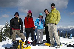
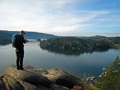
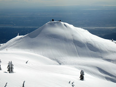
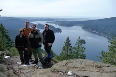
Category Archives: Day hike

Hollyburn Peak 29/03/09

Chris on Hollyburn:
“Cara, Christian, Leticia, Ming and Rob joined me on a quick trip up Hollyburn on Sunday. The weather was, of course, beautiful (hope I can keep this up all year). The snow was firm on the way up and softening in the sun on the way down. Snowshoes weren’t needed but it was slippy on the steep bits. The place was a zoo – many people on the trail and at the peak. In the shade, the air was definitely cool to cold but in the sun, it was almost shorts weather. The sliding on the way down is best near the top where it’s steep.”

IMGP3636

Garibaldi Lake 29/03/09

Rob M. on (yes, on) Garibaldi Lake:
“We drove up the Sea-to-Sky enjoying the remarkable vistas surrounding us on a day that easily exceeded our expectations. A flagon of caffeine in Squamish and we were on our merry way. A 2k walk to the trailhead and we were met by the forceful rushing sound of Rubble Creek and the Barrier standing majestic and articulated in the bright sun. Myself and Jamie quickly made our way up the Barrier in hikers while Mel, Sarah-Jane and Dan were strapped into pace-setting snowshoes. With a chorus of oohs and aahs, we perched ourselves for lunch on the Barrier enjoying the shenanigans of Whisky Jacks. Fully sated, and after hours of single track hiking, we descended through a few feet of fresh powder onto the wide expanse of Barrier Lake. A few minutes later we entered and exited another creek to be met by the larger Lesser Garibaldi Lake surreally covered in large puffs of pristine snow broken by rivulets of streaming water. Just before the canyon, we engaged the summer trail and were soon rewarded by the sight of Garibaldi Lake – we descended onto miles of flat searing white snow surrounded by Panorama Ridge, Gentian Peak, Garibaldi Mountain, Mount Price and Clinker Peak. Small pixels in the distance gained substance over time to become a couple of hiking/skiing clubs. We sucked in the grandeur of it all in and let it burn into our retinas and eventually returned. Boot-skiing our way down the trail as much as possible, we made excellent time – enough to enjoy a hardy meal and a brew in Squamish. Total elapsed time – just under 9 hours.”

Garibaldi Lake

Baden-Powell Trail 22/03/09

Steve on the B-P trail between Deep Cove and Lynn Canyon:
“What a pleasant surprise! After a sunny Saturday I was wondering if I had picked the wrong day, but as it turned out, the entire weekend was great. A full load of 8 did the one-way trip starting at the east end. What shocked me was how it really was not all that muddy. We were prepared for it, but the gaiters and poles simply were not needed. Also, we may have taken a grand total of 25 steps on snow and the streams were not as high as I had expected (I wonder if this might be cause for concern in the Summer months).

Regardless, hike season without snowshoes is definitely here for those willing to stay at low elevation. This trail was chosen because it offers rain protection even on the worst days, so if you have a nice forecast, I’d suggest leaving this one for the next time it’s “iffy”.

We put up a reasonable pace with this group and had a good time meeting new people. The downside was all of the calories that we burned over 4.5 hours were replenished by ½ a donut at “Honey’s” in Deep Cove.”

Lokking over Indian Arm and Grey rock.

Mt Seymour 22/03/09

Chris on Mt Seymour:
“Cara, Christian, Eric, John, Ribeka and Rob joined me on a trip up Mt Seymour where snowshoes really weren’t needed (but crampons would have been good). Despite a not great forecast, the weather was stunning. On the way up, the snow was of a styrofoam consistency – pretty solid with the tiniest bit of give. The marked route takes you to within 10m of the first peak (pump, whatever you want to call it). We ventured on to the second peak. From this point, the route to the final peak requires crossing some VERY steep terrain. A couple of us decided to attempt cutting a route but most people were quite happy to sit and enjoy the view here. On the way back, we sought out every butt- and boot-skiable slope available.

The afternoon snow was pretty sloppy in places as the temperature rose and, off the beaten path, postholing became frequent. In the shade higher up, some areas had a solid crust of slick ice.”

Seymour 2

Diez Vistas 21/03/09

Michelle on Diez Vistas:
“Tres Hombres & Un Bebé, Más Dos >> John, Erez and Eric joined me for a fabulous day of pure sunshine and clear views of Vancouver and the lower mainland, Belcarra and Deep Cove, Seymour and the white crested neighbouring mountains and Indian Arm. We all indulged in a little sun basking and eagle watching on the bluffs at viewpoint uno after lunch – at which point we picked up two additional Wanderung fellows who joined our band for the rest of the day. Along the ridge we encountered a few stretches of snow but the patches were shallow, compact and easily tread on – save for a couple steep parts, which poles proved useful on. We still did better than book time. The trail was in great shape with next to no mud and several other groups of hikers were out on the trail. Spring is here and so is hiking season!”

Diez Vistas Mar 21/09

Hollyburn Peak 26/12/08

Steve on Hollyburn:
“I admit it, I picked a really bad meeting spot. West Van has a pretty good bus system for getting people from the city to North Shore meeting spots but the parking lot I could see on Google maps was gone! Plus snow made it hard to just wait by the side of the road in a car. I strongly suggest Park Royal as a West Van meeting spot due to the bus hub, and quick access to the highway.

Thanks to Tim for the avalanche warning posted here: https://www.avalanche.ca/CAC_Bulletin_Regions. I simply would not have guessed the North Shore would have such extreme conditions. We decided to go as far as the signs and see what the rating on the trail was. There, it was rated `moderate’ and we took a heavily treed route, so we pressed on. The snow was blowing quite a bit and there were no views today, but plenty of recipe swapping and shower-curtain tobogganing. As Rich put it, any day on the mountain was better than the best day at work, and this Boxing Day was no exception.”

Elaho Valley 21/12/08

Christian at Elaho Valley:
“After 1 hour of white-knuckle driving on unplowed highways before dawn, Stuart and I were on edge, as we were each feeling apprehensive about this trip!! We each traveled from different places to reach Squamish. Along the way, we encountered ground blizzards, covered signs, and could not see the edges of the road at times. We met at the Tim Hortons in Squamish and chatted about the weather and conditions before dawn. By dawn, the wind was gone and visibility was great. With a safety plan in mind of being back at the car before dark, we set out for the Elaho Main road. We saw some amazing eagles along the way. I was surprised to see six eagles in one tree (see Flickr). By the time we reached 28 mile, the snow was deep enough that it limited our vehicle speed to 25 km/h. We calculated that we would be spending more time driving than hiking. No fun there! So we turned back. Quickly found a great alternate hike at Alice Lake park. We decided to do the 8 km Lake loop. We broke trail for two hours and had a marvelous time. On our hike in the park, we encountered many families with their little pre-schoolers taking advantage of the small toboggan hills. It was a great day to be out! After our 2 hour hike around the four lakes, we went to the Brackendale coffee shop. We easily chatted away two hours of the day, long before dusk. All and all, a good time spent in Squamish on the Winter Solstice.”

Virgin trail on clear day - Elaho Valley trip, Dec 21

Dog Mountain 20/12/08

Michelle on Dog Mountain:
“The -7 / -12 with wind chill factor definitely had us wondering and we were definitely a little on the cold side starting out (our toes were already cold from just standing outside the shopping mall!). But instead of bundling up more, we quickly heated up on the trail and inevitably began the customary strip routine by the time we hit First Lake. However, after reaching our end destination we didn’t stick around to enjoy the sunny view for very long: though the winds were calm it was just too darn cold to sit around for more than a cup of tea and quick nibble. The winter route is now marked and well trodden (although a couple of alternate routes have also been stomped out past First Lake). Good snow coverage save for a few steep, exposed, iced-over root patches not yet filled in. Good parking lot coverage too (of the vehicular type) as to be expected on a sunny day.”

Alpen Mountain 14/12/08

Chris on Alpen Mountain:
“Cara, Darcy, Dean, Mathieu, Roberto, Siegfried and Tania joined me in a search for the Hidden Valley Cabin on Alpen Mountain just east of Squamish. The Mamquam River Main (not the same road as the Mamquam Road that accesses the Elfin Lakes trail – this one is unsigned and just after the parking for the Chief) seems to see a fair amount of local traffic and was drivable to the Alpen Rd. The gate here was open so we drove in and parked just short of the first waterbar (200–300 metres up). Despite ferocious winds on the 99 and in Squamish, we encountered only light breezes even in exposed areas. But temperatures averaged around -10 C. We followed the main road but made a wrong turn about half way up (there are a lot of spurs) which lead us to a dead-end. After an attempt to cross-country to the main road, we gave up and back-tracked to the main road. Part of our party headed higher but still didn’t reach the cabin (locals said that it would have taken 4 – 4.5 hrs from the bottom). The snow varied from a couple inches at the cars to 2 feet of weightless powder around 1200 m.”

Garibaldi Massive from Alpen

Cougar Mountain 07/12/08

Chris on Cougar Mountain:
“Albert, Alex, Cara, Jamie, Nancy, Ribeka, and Tessa joined me in a snowy exploration of the western flank of Cougar Mountain. The road to Cougar Mountain (16 mile creek road) leaves Hwy 99 just after Green Lake. We encountered snow fairly early and the potholes had turned into slushy ponds (doesn’t look like this road is plowed but sledders probably use it later in the year). The hill after the bridge took some effort to drive up and we slipped and slid up to the stables to park. To get to the cedars from there, follow the road up taking a right at an obvious fork and sticking to the main road until you start to encounter faded signs and follow those. The road turns into a gentle trail and we found ourselves in the cedar grove about an hour after leaving the cars. We then headed off-trail following the creek uphill. We topped out at 1200 m overlooking a small pond and temperatures stayed above freezing for the whole route.”

Cougar Mountain - December 7, 2008