Melanie on Yellow Aster Butte:
“Surprisingly, not many signed up for this trip… maybe it was the turkey hangover or the early start or the border crossing or the last minute callout. Noman and I headed towards Mount Baker-Snoqualmie National Forest in hopes of hiking the Chain Lakes Loop. Unfortunately, the Visitor Centre is only open on weekends and we could not ask about the trail conditions. As we drove towards the parking lot, lots of snow began to fall, and visibility declined. It was an easy decision to change to another hike, so we chose the Yellow Aster Butte trail and it turned out to be a good choice! There were gorgeous fall colours, tons of blueberries, meadows, lakes and stunning views of the surrounding mountains including Baker. This hike is now easily one of my top five Baker hikes. An added bonus was minimal border wait times in both directions.”
Yearly Archives: 2010
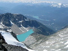
Tszil Peak 02/10/10
Irina on Tszil and Taylor Peaks:
“Dan, Pavel, Stephan, Carlos and Evgeny joined me, and Saturday morning we started the hike from the Joffre Lakes parking lot. Once near the upper lake, we came across a sign post and followed the route to Tszil glacier. It’s a fairly well trodden trail when on the grass or in the trees, but some route-finding is required on the boulder field.
Spotting the moraine, we first went to the right of it but ran into abundant deadfall. Oh well, let’s see what the moraine is like from the top. It turned out to be quite wide except for a couple of more narrow, half-a-foot wide sections. Then it’s all boulders up to the Tszil-Taylor col. We crossed a couple of small icy snowfields where I would have liked to have and ice axe or traction aides, especially if we were to descend the same way.
While Tszil looked somewhat intimidating from the col, the scrambling turned out to be a lot of fun with no exposure and excellent sturdy rock. The views were spectacular! The whole Cayoosh range was up on display, and Slalok so close! We didn’t even notice how 40 minutes on the top passed, and if we wanted to get to Taylor, we should hurry! So Pavel, Evgeny and I packed quickly and hastened down. From the col, it was 30 min to the top of Taylor, zig-zagging between short cliffs at a good speed. A few quick pictures, and down we go. Back in the col at 5:10 pm, with two hours of daylight left. Dusk descended on us at the second lake, and we caught up with the rest of our group between the first and the second lakes. Huge thanks to Dan who courteously accepted the role of a guide for the other two in the group and descended straight from Tszil, allowing us to bag a second peak.
See full report with geo-tagged pictures on Livetrails: https://livetrails.com/report/1205/0/Tszil_Mountain-Mount_Taylor_loop“
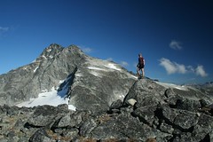
Tangled Summit 25/09/10
Ben on Tangled Summit:
“For braving the gloomy weather forecast, we were rewarded with clear skies and a great day for hiking. We set off down the powerhouse road shortly after the park gates opened and made our way to the far end of the Buntzen Lake to the Swan Falls trail head. This trail deserves its reputation as one of the steepest around. It took us nearly three hours at a steady pace to reach the junction it makes with the crest trail. Just a short ways beyond was a rocky open area on the ridge that afforded us some nice views. Although we found signs for the high points, none were actually labeled Tangled Summit which is in contradiction to both 103 Hikes 6th ed. and Google Maps. The trails system however was very thoroughly marked with clear signs at every fork and junction. We took the crest trail and part of the very muddy Lindsay Lake loop back to the south end of the ridge where we made our descent back to the cars.”
Coliseum Mountain 22/09/10
Erez on Coliseum:
“No takers, so I went by myself. Very long trail (I hiked from Lynn Valley), and it’s mostly climbing through forest. The trail becomes interesting once you get to the ridge between Lynn and Seymour valleys. I saw a mama bear and her 2 cubs. The trail is very well marked and snow free.”
Elfin Lakes 18/09/10
Malin at Elfin Lakes:
“Six adventurous Wanderung members braved wet weather and vehicle problems on Saturday morning and headed up to Elfin Lakes for the weekend. Light rain fell continuously on our way up to the Red Heather hut, but the showers got less frequent after that. By the time we arrived at Elfin Lakes the sun actually poked through the clouds and we had lunch by the lake. After lunch we left our heavy bags in the hut and headed towards the saddle between the Gargoyles and Columnar Peak. The trail was incredibly slippery, but the hike well worth it as the clouds started burning off when we reached the saddle. From the saddle we headed up to the Gargoyles, where we enjoyed great views of the Diamond Head, Diamond Glacier, Opal Cone and Elfin Lakes. Despite the wet weather the hut filled up completely and it was nice to retreat to the quiet tents. In the morning we headed towards the Opal Cone. Surprisingly we made it all the
way, despite some heavy rain and the washed out trail. We even had some nice views! The bridge over Ring Creek was in place, but people should always check: http://www.env.gov.bc.ca/bcparks/explore/parkpgs/garibaldi/trail_report.pdf for the most current information. Thanks to Rob for the directions to the
Cone and to everyone else who joined me on this great adventure.”
Mt Strachan 18/09/10
Michelle on Mt Strachan:
“Four drivers standing around with no hikers to drive. “No fair weather hikers please” means being prepared to hike rain or shine. Our group of 9 withered down to all the willing drivers, one of which still dutifully showed up to offer people a lift despite no longer being able to go on the hike last second due to unforeseen circumstances. A group of 4 of us took on the BP/Old Strachan Trail. Paul G’s trail report in the Wanderung archives proved to be the ticket to getting us there (indeed, don’t follow Dawn Hanna’s description use Paul’s, thanks Paul!). We decided to stop just short of the final summit approach as we came across a mama bear and cub who decided to go the way we needed to go, in poor visibility conditions (and it was also evident the view was not going to clear in time for lunch – the view would wait to appear until after we were sipping hot bevys in West Van). 😉 All in all, a good time had by those who went. But how many call outs for “drivers needed” this weekend (while 4 drivers were bailed on for this trip)? What a shame. Bailers, think twice about how taking a seat on a trip affects others – on your trip and potentially other people’s.”
Singing Pass 28/08/10
Su-Laine hiking the Musical Bumps via Singing Pass:
“Do this trip soon! Eight of us headed up the steady gradient of the Singing Pass trail on Saturday, towards the meadows where a variety of alpine flowers were in bloom and more had yet to open. Russet Lake had plenty of excellent camping spots. It got cold: we measured minus 2 degrees at night while we were still awake! On Sunday six of us day-hiked to various altitudes on Fissile Peak in glorious sunshine. It’s a tricky scramble and only one of us got to the top, but even a partial ascent gave excellent views.
After waiting out a spell of bad weather at the Russet Lake hut, we hiked out in temporarily less-bad weather along the Musical Bumps trail. I discovered that a scrambling helmet is fun to wear in a hailstorm – you hear the clatter of hail while keeping dry and cozy. The fog cleared and the sun came out occasionally, enough to appreciate the beauty of the region, which included black bears and gregarious marmots. The (free) gondola to the village was scheduled to run until the late evening that day, so it was past 7pm by the time we got to the Dubh Linn Gate pub for dinner. The gondola is scheduled to run until late a few more times this summer (Sept 3, 4, and 5), but call Whistler Guest Services (1-800-766-0449) to confirm.
Thanks to everyone for making this such a fun trip with great company.”
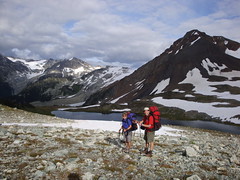
Mt Outram 28/08/10
Peter A. on Mt Outram:
“Rob, Rebecca, Grazyna, Adrian, Irena, Jen, Jonathan and I braved snow, cloud cover and freezing winds to successfully ascend Mt. Outram. A fantastic adventure, that started with a fleet hike through a beautiful hemlock and Douglas fir forest. Once clear of the trees, after gaining approximately 1,000 metres, we entered a large, picturesque sub-alpine bowl, that revealed that fresh snow had blanketed the high ground, including the rest of our ascent. The snow was beautiful, but made the ascent up the steep, massive boulder field a little slippery. With a keen focus and much exertion, we gained the first summit in 3h 45m from the trailhead. After a bit of moderate scrambling, made trickier by the fresh snow covering the rocks and scree, we made it to the “true” summit. 1800 metre altitude gain. Despite the heavy cloud cover and cold winds, the cloud ceiling was high and there was plenty of blue sky to allow for magnificent 360 degree views. Very cool to see the North Cascades, Baker, and all the familiar Chilliwack mountains from this perspective. We found enough windbreaks and caught enough sun through momentary breaks through the clouds that we stayed on top about 20 minutes. Two other highlights of the hike: Adrian photographing a beautiful mountain goat in the sub alpine, and during our descent, Adrian photographing two ground squirrels overseeing the fields of blueberries where we had stopped to graze. Trail conditions and markings were excellent throughout, even on the final boulder field (just required a little more patience in spotting the red painted rocks). The descent took us 3 hours, and our knees were happy to see the parking lot. We had been on the trail a total of 8 hours. Great day, great hike, great people, finished off with a great meal at the Blue Moose Café in Hope.”
Yak Peak 15/08/10
Erez on Yak Peak:
“Susanne, Rich, Hiromi, Adriana and I woke up early on Sunday and drove on the Coquihalla to the base of Yak peak. The trailhead was pretty easy to find using the directions and way points posted on Club Tread. It was also very well marked all the way to the peak. There was almost no snow at the top. The snowfield was almost completely gone, and you could easily bypass it – no need for any special equipment. It was a great trip with a great company. Thanks a lot to Rich and Adriana for driving.”
Mt Weart 14/08/10
Ben on Mt Weart:
“I have had a recent urge to do something really challenging before the days begin to grow short and weather too uncertain. This trip to Mt. Weart delivered that challenge in full. The abundance of loose rock and lack of snow made this a demanding route. These difficulties were compounded by the sun toasting us at nearly 30 degrees. The route was composed of four distinct segments. The initial portion skirts right along the toe of the Wedgemount glacier and then climbs up the slope on the left side of a creek that is flowing down from a basin above. The route then crosses this basin along a second glacier and ascends a loose slope on the opposite side. It would have been great to see more snow here, but we made do by picking our way up through snow and scree. This slope tops out at another higher and smaller basin/bench where at last the base of the final ridge is in sight. The third part of the route, that is reportedly marked with cairns, is up through the cliffs to the lowest part of the ridge. If there were cairns in the cliffs, they were not obvious. We all picked slightly different lines up and found the top with no problems. There seemed to be plenty of ways to go that were only moderately exposed, but this section would prove to be a bit tricky on the way down. Upon gaining the ridge, we were rewarded with phenomenal views out across the immense Weart Glacier. From here we walked the ridge to the base of the summit and then scrambled our way up the final slope, which consisted mostly of large, semi-stable rocks. It was hard work in the heat of midday, but reaching the summit was a glorious moment and made it all worth while. We had views of…. pretty much everything. A big thanks to Peter, Beau, and Tim for joining me on this very memorable day!”