Hurrian on Coliseum Mountain:
“Six of us headed up Coliseum on Saturday. After the long walk to Norvan Falls we pushed up the very steep part of the trail. Where it levels off, it was muddier than normal, probably because of the snow runoff. Even on the ridge though, there was very little snow, which is good because the very moderate and low exposure scrambles might have been a bit dodgy if they were snow covered. We made it to the summit in about 3 or so hours and had a nice lunch. Thanks to Gareth, Norbert, Iryna, Julie and Danielle for a great hike in great company.”
Tag Archives: Coliseum Mountain
Mt Burwell 28/08/11
Peter A. on Mt Burwell:
“Jeremy and I reached the summit of Mt. Burwell via the steep trail from the Lower Seymour Conservation Area. A great day for hiking, playing in snowfields, and taking pictures.
The trail is punishing on the way up: very few breaks from the steep gradient. Fortunately, it’s a pretty trail through the hemlock, Douglas fir, up rock faces and roots, and easy to follow. There is one tricky spot to be aware of that the guide books don’t mention: finding the trail off of the Seymour Valley Lookout (a huge rocky dome/promontory). When you arrive on top of the Lookout (about 1 – 1.5 hours into the hike), there are few cairns/trail markings to guide you onwards. You don’t need them to walk the 3 minutes on the east side of the flat promontory to its northern end for terrific views (Mount Elsay, Mount Seymour, and Seymour Lake to the east and north east, and Coliseum Mountain and Mt. Burwell to the west). However, once you’ve feasted your eyes, rested, and are ready to move onwards – i.e. back down the promontory and down to a col that separates the promontory from Coliseum Mountain – the lack of cairns/trail markings on top can make it difficult to find the trail. There are two choices: the easiest way is to walk back on the west side of the promontory in the direction of the col until you see some cairn and flagging that will lead you to the trail to the col. The second way is to retrace the way you came up, i.e. back down the east side of the promontory and back on the trail for about 5 minutes. At that point, just beyond the edge of a small clearing, on your right (facing downhill), look for flagging on some trees. This is a branch in the trail that you likely didn’t see on your way up. This trail runs west, skirting along the bottom of the promontory and to the col (it meets up with the trail coming down from the west side of the promontory.
The trail along the col and up to the intersection with the Lyn Valley Coliseum trail had spots of deadfall, mud and boulder fields to contend with, but trail markings were always there to be found with a little patience and a keen eye. And when ascending Burwell from the tarn that lies between it and Coliseum, stay to the left even though it looks like your approaching a forested cliff: the trail goes up a cleft in the rocks and is easy.
We ascended Burwell in 4 hours (a good pace), and, including the 19 km round-trip bike ride from the parking lot to the trail head (a lot of uphill pedalling at the end of the day!), we were on the go for 8.5 hours.”
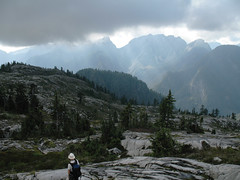
Coliseum Mountain 22/09/10
Erez on Coliseum:
“No takers, so I went by myself. Very long trail (I hiked from Lynn Valley), and it’s mostly climbing through forest. The trail becomes interesting once you get to the ridge between Lynn and Seymour valleys. I saw a mama bear and her 2 cubs. The trail is very well marked and snow free.”
Coliseum Mtn 20/09/09
Rob M. on Coliseum Mountain:
“We first laid rubber an a rolling, museum grade asphalt road, biking towards an underrated jewel on the North Shore, Coliseum Mountain. After this idyllic 9 km, a 1 km Dr. Jekyll and Mr. Logging Road change-up ends at an unmarked but obvious trail. The overtaped Christmas Tree look beginning belies the rugged and unrelenting ascent festooned with small root and rock scrambles through new and old growth hemlock. The trail from the 1000 m Paton Lookout takes you down into a small valley then a grind up through a bolder field and the 1441 m summit of Coliseum. The forces of good prevailed after a dramatic struggle between sun and cloud and we were awash in warm light. Lotsa blueberries along the way and hence one bear encounter, who had better things to do than deal with humans. The Coliseum to Burwell (1521 m) hike is a must-do over a large field of smooth open granite for a modest net elevation gain. We met one intrepid hiker travelling incognito with full pack from Cathedral Mountain. The rangers here are kept busy de-taping The Needles to Cathedral Mountain corridor made by renegade hikers. There are a couple of large, deep R&R tarns before stumbling down the slicker-than-heavily-oiled-banana-peel descent. To take us out of our (dis)comfort zone, Eric led us on an off-trail bushwhack around the summit. The bike ride back was a scream! A full 10-hour day.”