Tag Archives: Manning Park

Windy Joe, 25 Feb 2017

Colleen C. on Windy Joe:
“It was a great group that joined me for a snowshoe up to the Windy Joe fire lookout. It was a pretty uneventful, straightforward drive and hike – which personally was appreciated after a few recent misadventures! Particular thanks to Lisa for driving all the way out from White Rock, Phil for bringing homemade cookies, Haiying for supplying zip ties for makeshift snowshoe repairs, and Gail for good conversation.

The trail was packed all the way and follows an obvious path up, fairly low snow levels overall and few deadfalls. Just a heads up that the start is now along the first couple of km of the Similkameen trail. Seems like this is due to a permanent loss of a bridge, so some of the info online is out-of-date and the km markers higher up are a little out. The Club Tread route info page was accurate.”

Frosty Mountain, 24 Sep 2016

Eugene Y. on Frosty Mountain:
“Seven of us went to explore the legendary alpine larches in Manning Park. We parked at the beautiful Lightning Lake and proceeded along the well-maintained trail toward Frosty Mountain. The trail was in excellent shape and easy to follow. After a two-hour pleasant walk amid bright-red and yellow fall colours we had a lunch break at the Frosty Creek campsite. After another half-an-hour walk we finally reached the Larch Plateau and then continued along the partially snow-covered trail toward the mountain. The larches had just started to turn yellow, so the predominant colour was golden-olive. The snow on the ground was already partially covered by yellow needle-like leaves.

As we started climbing the slopes of Frosty, the snow got deeper and reached about 20 cm at places. However, the final walk along the ridge was mostly snow-free.
Finally, we reached the summit. The views on the surrounding partially-covered snow peaks were truly breathtaking!

The descend was was fairly straightforward, although some portions of the trail were a bit slippery. We didn’t use microspikes, however, we found hiking poles really helpful.

Some stats. At a leisurely pace while taking lots of pictures, it took us about 4.5 hours from the parking lot to the peak and 3 hours to get back to the car.”

The final ascend to Frosty

Mt Kelly, 17 Apr 2016

Phil A. on Mt Kelly:
“Lured by blue skies and warm temperatures, we set out to conquer Mount Kelly and the ridge to Nordheim Peak in Manning Park. We attacked from Allison Pass (N49° 06.924′ W120° 51.805′). The road had snow from the get go. After getting off track due to some fallen trees we had to bushwhack back on course. At the end of the road, the trail through the woods to the peak of Mount Kelly was slightly difficult to follow due to inconsistent flagging. Once at the peak, the trees thinned out and we easily navigated along the snow-covered ridge (which progressively slushed up in the spring sun). We then walked almost to Nordheim Peak to luxuriate in the sunshine before heading back.

Total elevation gain: 1400 m.
Snowline: Dependent on the side of the mountain, but the road was covered from the road/trail up. Snowshoes necessary.
Distance: 18 km.
Total Time: 7.5 hrs including lunch, breaks, and faffing.”

Skagit River, 3 May 2015

Stephen H. on the Skagit River Trail:
“This is a nice hike for spring. Andrew, Angela, Bob, Ivy, and Paul joined me for a 20-km stroll along this gold-rush trail. The rewards: old-growth groves, harlequin ducks, a mine, and a waterfall. And solitude too, as we only encountered a few other parties.”

Tullameen Meadows, 15-16 Jun 2013

Chris N. in Tullameen Meadows:
“Colleen and Rob joined me for a trip into the Cascade Recreation Area this past weekend. The trailhead is just past Rhododendron Flats in Manning Park. We elected to take the Whatcom Trail on the way up and encountered our first bit of snow about 100 m below the pass to Punchbowl Lake. We crossed over the Punchbowl outflow stream on a snowbridge and then back again lower down on the mostly submerged log bridge. Snow covered 90% of the trail between the pass and Snass View Camp but the campsite was largely melted out and dry. Trailhead to Snass View at an ever moderating pace took 7 hours. An after-dinner ramble was called due to dark but we were quite close to the hidden lair of the secretive snow frogs. The night was mild and the next day dawned bright and blue. We hiked down to Tulameen horse camp encountering an interesting clear water spring on the way (future site of our spa and resort). The trail was about 80% snow near Snass View but almost all traces of snow were gone from the Tulameen area. Lots of deer and elk sign but no actual sightings (except for the elk-on-walrus episode). We returned by the Dewdney trail following moose prints. Early on, it was obvious that feet were not going to stay dry with the numerous creek crossings. In several places, the trail was under a foot of running water. Snow disappeared around where the creek goes underground. From that point to Dry Lake, there was copious bear scat and trails tramped down through the lush vegetation. Dry Lake wasn’t (in that it was full of super-clear eerily blue water). Light on-and-off sprinkles started at a stop in a cedar grove where we listened to distant thunder rumbling. We got back to the trailhead 4 hours after leaving Snass View. We stopped at the Wildcat Grill between Hope and Chilliwack where we enjoyed food and a spectacular thunderstorm on the patio (and stayed moderately dry in the process). Road closures for paving on the 1 just north of the Port Mann caused a backup starting at the south end of the bridge and probably delayed our arrival in Vancouver by about 45 minutes (apparently, these start around 9 pm every night and would affect any late returns from any hikes to the east).”

Snass Creek is the trail.

Nicomen Lake 15/09/12

Steve at Nicomen Lake:
“The Nicomen Lake trail has 2 potential purposes, and a nice hike is not one of them. At 17+ km each way on a featureless trail I can only recommend walking this trail if you are a) really into fishing and want a guaranteed catch of many fish or b) as the exit point for the Heather Trail so that you don’t have to backtrack (instead of hiking 23 km back the way you came you could have left a car at Cayuse Flats).

Were it not for the excellent conversationalists that joined my callout (Jangwon and Darren), this trail would have been even more tedious. The lake itself is nice, and the camping area on its edge – brilliant – but this is no Wedgemount, or even Garibaldi. We did hike to the ridge in the morning which was worth it, but if you were hiking the Heather Trail this is how you would approach your final campsite anyways.

This was a slog as evidenced by 6 sore feet and matching legs. The trail is groomed, Garibaldi style, so at no point is it “steep”, just really really long and uphill the whole way there (leaving was far more enjoyable but still long!).”

Mt Outram 28/08/10

Peter A. on Mt Outram:
“Rob, Rebecca, Grazyna, Adrian, Irena, Jen, Jonathan and I braved snow, cloud cover and freezing winds to successfully ascend Mt. Outram. A fantastic adventure, that started with a fleet hike through a beautiful hemlock and Douglas fir forest. Once clear of the trees, after gaining approximately 1,000 metres, we entered a large, picturesque sub-alpine bowl, that revealed that fresh snow had blanketed the high ground, including the rest of our ascent. The snow was beautiful, but made the ascent up the steep, massive boulder field a little slippery. With a keen focus and much exertion, we gained the first summit in 3h 45m from the trailhead. After a bit of moderate scrambling, made trickier by the fresh snow covering the rocks and scree, we made it to the “true” summit. 1800 metre altitude gain. Despite the heavy cloud cover and cold winds, the cloud ceiling was high and there was plenty of blue sky to allow for magnificent 360 degree views. Very cool to see the North Cascades, Baker, and all the familiar Chilliwack mountains from this perspective. We found enough windbreaks and caught enough sun through momentary breaks through the clouds that we stayed on top about 20 minutes. Two other highlights of the hike: Adrian photographing a beautiful mountain goat in the sub alpine, and during our descent, Adrian photographing two ground squirrels overseeing the fields of blueberries where we had stopped to graze. Trail conditions and markings were excellent throughout, even on the final boulder field (just required a little more patience in spotting the red painted rocks). The descent took us 3 hours, and our knees were happy to see the parking lot. We had been on the trail a total of 8 hours. Great day, great hike, great people, finished off with a great meal at the Blue Moose Café in Hope.”

Manning Park 31/07/10

Michelle on the Skyline and Silverdaisy trails:
“No rest for the wicked! Three early mornings allowed us to maximize the mileage on this 500 something cumulative km trek spanning two provincial parks. Skyline as a cross over hike was a fun and unique experience with 5 hikers from Skagit and 4 hikers from Manning enjoying more sunshine than drizzle (and just a flash of lightning) before meeting up at Mowich for an enjoyable evening together. West of Mowich, Skyline does offer fine views of Ross Lake and the North Cascades. However continual views of Hozameen, endless peaks, valleys and the Lightning Lakes chain, kilometres of wildflower meadows, access to ascend Lone Goat and Snow Camp Mountain (a fine lunch spot enjoyed by both groups) is afforded by Skyline east of Mowich. Both groups also tackled a portion of the Hozameen Ridge trail 900 m west of Mowich (a spectacular ridge walk on a clear day). Reunited in Manning a dip in the river, some grub at the East Gate Diner, some refreshments from the General Store and cards at the Hamptons rejuvenated our band.

Of note – still some water trickling at Mowich, but I was glad I packed in all my water. Bugs (particularly flies) are better than last year in Manning, but were enough of a nuisance (as proved by my swollen eyelid bite). The snow is ALL gone and flower season should hit full bloom in the next few weeks.

The Silverdaisy trail is in fine shape, though easy to get side tracked and wander off in the beautiful meadows up top (pay attention and look sharp for the flagging). Silverdaisy makes you work for it, but the payoff of alpine meadows with a panorama of mountain views made for a very satisfied group. Mental or GPS breadcrumbs are useful for descent from the summit (easy to loose the route you travelled in on with little or no meadow footbed). The through and through hike may have shaved some time but navigation to Cayuse took effort and required GPS (lots of roads, lots of choices, little or no distinguishment on screen between active roads and now tree choked roads). An enjoyable adventure, but best (and more scenic) to just return via Sumallo Grove.

Summary: Nine enthusiastic hikers – check! Two cars + two phenomenally dedicated drivers – check! Two through and through hikes completed- check! Several frosty shakes and slices of pie consumed. Nine content hikers.

PS It’s a small world – 4 out of 8 groups on Skyline knew each other by 0–1 degree of separation, 2 groups of which were fellow Wanderungers.”

Manning Park 24/07/10

Heather in Manning Park:
“Seven enthusiastic people set out on Friday afternoon, bound for a weekend in Manning Park. We all rode up in Chris’s amazing transformer van – everything from hot water to cook stoves to coolers to a bed was in there (although passengers slept in tents.) We camped just east of Manning Park, in a free and beautiful spot on the edge of the Similkameen River. Saturday had one person off fishing for the day, one person solo canoeing, and five of us heading up Skyline trail to Snow Camp mountain, in beautiful sunshine and completely blue skies. We had a few bizarre encounters with zombie-like people that were doing an ultra-marathon (100 km or 100 miles, depending on who you talked to!), including helping one woman down the trail to meet up with her companions. These people had run and walked for 30 hours or so, across the mountains and all night long, and we all agreed that it was pretty sad to see them so zoned out in such a beautiful environment. The vistas opened up to stunning alpine meadows, dramatic drops way down to the lakes, beautiful distant mountains, and an incredible variety of wildflowers. We took a total of 6.5 hours to hike this trail – hot but very rewarding, and the swim in Lightning Lake after was very refreshing. That evening five people drove back to the lake for a full-moon paddle, while two of us slept well! Sunday involved a lazy morning, and then canoeing and swimming in Lightning Lake again – enjoying the refreshing water and relaxing atmosphere. The evening was topped off by a good supper at the Manning Park Pub, and then a drive back to Vancouver in the evening sun. And enjoyable weekend had by all… Thanks to Chris for organizing, driving, and supplying the amazing extra equipment and comfort of the van.”

group on the summit

Mt Frosty 10/09/09

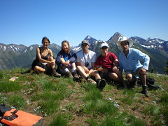
Tracy on a frosty night on Mt Frosty:
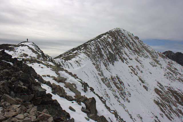
“Ten people turned out for the Mt. Frosty overnighter: Chris M. (the organizer), Tracy, Brenda, Lana, Dorothy, Lucy, Jeff, Daniel, Paige, and Sebastian. It was a beautiful Saturday morning, but decidedly nippy out as we started from the Lightning Lakes parking lot. The plan was to camp in the larch meadows, but when we reached the aptly named Frosty Camp at 12:30, we discovered it was bitterly cold and made a group decision to set up there, since we’d be able to have a fire there. After setting up camp, we continued onto the beautiful golden larch meadows. The trail was quite slick due to ice; crampons would have been nice but everyone made it in their boots.

Once in the meadows, unfortunately Chris had to turn back due to increasing flu symptoms. A few others decided to join him on the journey home, having seen what a cold night it was going to be. Chris kindly waited while everyone continued with the rest of the group to the Frosty summit. After taking in the stunning 360 degree views, we turned around; some back to camp, some back to the car with Chris.

Chris left us a plethora of treats to enjoy: wine, cookies, and Thanksgiving ham. We shivered around a campfire that barely seemed to give off any heat at all. Huddling close together, we enjoyed Chris’s treats, except for the ham, which we saved for breakfast. There was some debate over who would sleep with the ham to keep it from freezing. In the end this job fell to Jeff, I think.

We estimate it reached -15 C overnight. In the morning we hustled out of there, looking forward to getting warm. A stop at the Chilliwack airport for its famous pies finished off the outing quite nicely.

Many thanks to Chris for organizing, and so sorry he couldn’t be there to shiver in the cold with us.”