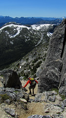
Andrew R. on Williams Peak:
“I was joined by Rebecca and Valerie on a gorgeous Friday for a hike up to Williams Peak overlooking the Chilliwack Valley. We got an early start and arrived at the well-marked trailhead at 9:30. The trail climbs steeply up to the top of Williams Ridge and then it is a easy (but long) walk along the treed ridge to a rocky knoll where we got out first clear view of the peak itself. We stopped at the knoll for a bit of lunch and to mull over the best route through the basin towards the peak. Luckily I had gotten advice not to descend into the basin but to continue up to the second knoll where we eventually spotted a cairn that told us we were heading in the right direction. Carefully following cairns and flagging, we traversed the side-slope on the left (north) side of the basin. This saved us having to lose and regain a lot of elevation – a huge help! (This route doesn’t seem to match with the route shown in Matt Gunn’s scrambles book. He seems to drop down into the basin.) Along the way Rebecca’s sharp eye spotted a momma and baby black bear moving quickly up the basin below us. It was her first bear sighting and an exciting spotting. We continued across the boulder field at the base of the peak (loudly, in case the bears were still in the area) and gained a rocky ramp that took us around to the scrambling gully on the south side of the peak. There seem to be a few options here, but all the routes seemed to converge on the main gully, which is STEEP. Some fun scrambling up this section. We reached the summit and enjoyed a good 45 minutes or so with fantastic views in all directions before reluctantly making our way down. We carefully retraced our route to find the flagging and the route around the side of the basin. At this point you are very glad not to have to descend into and climb back out of the basin! After gaining the ridge and having a last look back at the impressive peak we’d just descended from, it was a long dusty march back through the trees to the car. A long and tiring day, but the good company, fun scrambling, and great summit views made it totally worthwhile.”
Yearly Archives: 2010
Brandywine Mountain 08/08/10
Esther on Brandywine Mountain:
“We had a hard time driving to the trailhead. Shortly after turning left off Hwy 99, vehicles should make a sharp left turn on to an unpaved road towards “Brandywine Valley” upon reaching the junction where the paved road continues on the right to Callaghan Valley Ski Area. On the unpaved road, we passed a factory and then a big dusty parking lot before reaching a billboard. After that, the road branches were usually blocked off. We could have followed the main road until the junctions that 103 Hikes and Scrambles of SW BC mention, if the road hadn’t been so bumpy and steep in parts that we thought we had to be lost. One of the vehicles had to park half-way up. Our other vehicle (4WD) relayed the stranded half of the group to the trailhead. 2WD vehicles will need good clearance to make it almost to the trailhead.
We hiked from noon to 8:30pm. The approach to the meadows was steep, muddy, and well-marked. There was no snow in the meadows, but there was way more mud and mosquitoes then the wildflowers that were just starting to bloom. Hello gaiters!
After crossing the meadows and small streams, we hiked up a big snow patch over the scree below the ridge leading to Brandywine Mountain. The route was probably further left of this snow patch. We then followed the ridge to the top of Brandywine Mountain, over a little scree, a nice dirt path, a little snow, and big boulders. Amazing views when clouds moved aside briefly.
We returned along the ridge to the big snow face and slid down it for 30 minutes. Then we hiked back fast because the mosquito army was bombarding us full on.
Out at 8:30 pm, then we relayed people to the stranded car, and finally rolled into the Watershed Cafe for dinner at 9:40 pm. Long day, but what a great group!”
Lost Valley 07/08/10
Chris exploring the Lost Valley:
“The weather may not have been ideal and the bugs fairly bad but we had a nice surprise which more than balanced this trip. With no signups, Cara and I were free to join a WCWC trail building trip that was, coincidentally, also going up the Wade Creek trail. Both the Haylmore FSR and the various Wade Creek roads are in excellent-to-decent 2wd condition and it’s possible to park within 1 km of the bridge over the creek. The trail is steep with an average grade of at least 15% and sticking to the ridge crest even when it doesn’t seem like a good idea. There’s some blowdown around the mid-point of the route but it’s well flagged. The WCWC is improving the trail by adding switchbacks when needed. The final stretch side-hills above steep slopes. The trail fades just below the lakes near the pass. With a bit of trail-building thrown in, we got to the lakes in about 5.5 hours. From the pass, we wandered ridges and meadows to reach deep into Lost Valley to its headwaters. You need to pick your ridge ascents and descents carefully. The lower meadows were lush with plants to our shoulders at times and footing was tricky because we couldn’t see our feet. Along with more ptarmigan and pika encounters, the highlight of the trip was the multiple wolf sightings we made (3 out of 4 days were wolf days) including watching a litter of pups play in a meadow for an hour or so.”
Black Tusk 31/07/10
Dan on Black Tusk:
“Technical scrambles should ideally be attempted by experienced hikers; but not if you witness the woefully underequipped throngs that storm Black Tusk every summer. Thinking I would tread a middle ground, I took a mixture of seasoned scramblers & a few adept hikers who are otherwise new to scrambling to try to safely tackle this SWBC landmark.
Saturday morning found 10 joyful Wanderungers hiking up to the subalpine that are Taylor and Black Tusk Meadows – the flowers are now nearing full bloom and the mosquitoes minimal. We made good time, finding ourselves having lunch at the 1805 m mark looking at Garibaldi Lake and the surrounding high peaks at noon. One hour later and we were at Black Tusk base, awaiting our turns to have a go at the chimney.
Putting a lead, a middle, and a sweep in the climbing procession, all ten of us gave it a try in going up the chimney. After waiting out interminable streams of hikers both up- and down- climbing the chimney – and with me trying on the role of `traffic controller’ in the initial portion – the eight of us who cleared the chimney finally completed the 10-minute scramble to the top 1:15 after starting.
With a blue sky panorama at the top, we marvelled at the surrounding cirques, and at Cinder Cone below and other wondrous geological formations & glaciated peaks all around, all the while tirelessly clicking away at our cameras.
After lending assistance to an injured party (kudos to John K. for his advanced first-aid kit and training) we made our way down, mindful that storm clouds had started to move in. At around Black Tusk Junction, the sky emphatically opened up, with big bolts of lightning and thunder and torrential downpours making us sprint down to treeline.
In this well-matched group of blithe and seasoned hikers, a jovial and funtastic time was had by all and we carried the jolly-making to the Shady Tree Pub after. Out of that came an alluring idea for our next Black Tusk adventure: the Helm Creek Meadows approach. Can’t wait!”
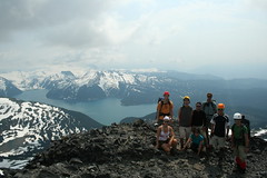
McGillivray Ridge 31/07/10
Chris on McGillivray Ridge:
“Cam, Cara and I spent 4 days on and around McGillivray Ridge on the edge of the Bendor Range with a mix of thunderstorms and smoke haze. Smoke kept the big animals away but we saw many ptarmigan families and marmots and a few pikas. The Hurley is in rough shape (washboarding and exposed rocks) but still 2wd. The East Hurley to Bralorne and the Kingdom Lake FSR are also both 2wd (and in nicer condition). We parked at the start of the McGillivray Pass road and hiked up. The alders at the start of the road are growing in again but it’s still easy to maintain hiking speed. There’s a few blowdowns on the road as well. We left the road for the high trail and found that, once you hit the meadows, the trail is hard to follow due to non-use and I was working off memory most of the time. We camped on the ridge near where the trail crosses over and used melting snow fields for water. There’s still lots of snow as we found on the second day when we continued along the ridge: at one point we encountered an 8-m-high drift. We found and packed out some old garbage including a leg-hold trap embedded in the tundra. We made a try for Whitecap Mt on our third day by following the horse trail down into Connel Creek. This part of the trail is in better shape but still disappears in lush meadows. We passed the Chilcotin Holidays cabin (in poor shape because there’s no door to keep wildlife out). The meadows beyond were the lushest I’ve ever seen – up to our waists in flowers and couldn’t see our feet. There were remnants of the trail heading up a creek to the west of Whitecap but too hard to follow. We ran out of time with 400+m still to go but with the steep part of the climb (40 degree slopes) done. On our last day, we bypassed McGillivray Mt and headed NW along the ridge – much narrower than the eastern half before dropping down, sidehilling around Royal Peak and down the ridge to the Piebiter roads. Most of these roads had been cleared for ATVs perhaps last year but those that aren’t are slide alder hell. Crossing Piebiter Creek (knee-height), we checked out the old Piebiter cabin (sturdy but in need of a good clean-out) before heading down to the car again.”
Manning Park 31/07/10
Michelle on the Skyline and Silverdaisy trails:
“No rest for the wicked! Three early mornings allowed us to maximize the mileage on this 500 something cumulative km trek spanning two provincial parks. Skyline as a cross over hike was a fun and unique experience with 5 hikers from Skagit and 4 hikers from Manning enjoying more sunshine than drizzle (and just a flash of lightning) before meeting up at Mowich for an enjoyable evening together. West of Mowich, Skyline does offer fine views of Ross Lake and the North Cascades. However continual views of Hozameen, endless peaks, valleys and the Lightning Lakes chain, kilometres of wildflower meadows, access to ascend Lone Goat and Snow Camp Mountain (a fine lunch spot enjoyed by both groups) is afforded by Skyline east of Mowich. Both groups also tackled a portion of the Hozameen Ridge trail 900 m west of Mowich (a spectacular ridge walk on a clear day). Reunited in Manning a dip in the river, some grub at the East Gate Diner, some refreshments from the General Store and cards at the Hamptons rejuvenated our band.
Of note – still some water trickling at Mowich, but I was glad I packed in all my water. Bugs (particularly flies) are better than last year in Manning, but were enough of a nuisance (as proved by my swollen eyelid bite). The snow is ALL gone and flower season should hit full bloom in the next few weeks.
The Silverdaisy trail is in fine shape, though easy to get side tracked and wander off in the beautiful meadows up top (pay attention and look sharp for the flagging). Silverdaisy makes you work for it, but the payoff of alpine meadows with a panorama of mountain views made for a very satisfied group. Mental or GPS breadcrumbs are useful for descent from the summit (easy to loose the route you travelled in on with little or no meadow footbed). The through and through hike may have shaved some time but navigation to Cayuse took effort and required GPS (lots of roads, lots of choices, little or no distinguishment on screen between active roads and now tree choked roads). An enjoyable adventure, but best (and more scenic) to just return via Sumallo Grove.
Summary: Nine enthusiastic hikers – check! Two cars + two phenomenally dedicated drivers – check! Two through and through hikes completed- check! Several frosty shakes and slices of pie consumed. Nine content hikers.
PS It’s a small world – 4 out of 8 groups on Skyline knew each other by 0–1 degree of separation, 2 groups of which were fellow Wanderungers.”
Flora Lake 31/07/10
Carolyne at Flora Lake:
“Eight intrepid Wanderungers set off to do the Flora Lake Loop. We were a well matched group and talked for most of the almost 10 hour hike! This hike has diverse vegetation and gorgeous views of surrounding peaks and the Chilliwack Valley. An interesting ascent through hemlock forest gave way to a traverse around an alpine bowl complete with wildflowers and then up over a wide pass. We decided to do a short detour to Flora Peak with 6 of our 8 going to the top for a look around. Then we started to descend to Flora Lake. This was the start of many descents! We kept remarking that it didn’t feel like we’d gained so much elevation, but we had: 1160 m. The trail continued traversing the west slope above the lake, weaving among the Douglas fir. Then came the first of many, many rock slide traverses. I had a moment of inattention, fell… and we ended up with an unplanned break as I got my knee bandaged up. No permanent damage done and on we went eventually descending to Post Creek but not before we could see Greendrop Lake peaking through the trees. At Lindeman Lake two of our crew braved the cold water for short dips. We couldn’t see them go in, but we sure could heard them! After what felt like a pleasant stroll to the other end of the lake, we descended again to the trail head. The trail is well marked and maintained throughout, there’s just one tricky bit at Post Creek – don’t go over the log bridge with signs on it saying ‘Greendrop Lake’ and ‘Trans Canada path’, take the path going to the left. Dinner at the Jolly Miller completed our day with a return to Vancouver about 11pm. Everyone agreed it had been a great day.”
Bowron Lakes 25/07/10
Cam paddling the Bowron Lakes solo:
“An unforeseen situation and my paddle partner for the trip had to back out. Not one to back out of challenge or an adventure I went solo with words of encouragement. I think those words where you’re crazy, nuts or you’re going to get eaten by a bear.
My GPS recorded 130 km round trip and 4 days 6 hours and hardest section was the last dock, ramp going to the campground. Shake my fist in the air at BC parks engineering department!
Forecast was for a sun all week long!! YES! Orientation was a 9 AM then the portage to Kibbee Lake a large group of people 24-26 but only 7 where ready to go. Was first out of the gate and that was the last I saw of the crowds. The next 4.5 days of blazing sunshine 😉 was pure tranquilly. The many warnings about full campgrounds by early evening where never found.”
The Chief 25/07/10
Keith on the Chief:
“The weather was phenomenal and the company even better. With some shuffling went to the around we ended up with one full car. We found parking (luckily), and set off up the Chief. Forgot how quick it is! We just went to the first peak and it was crowded, but it was clear and warm. I learned from the other people feeding the chipmunks that they do not like dried papaya. You don’t feed bears, why chipmunks? Given the opportunity I think they would attack 🙂 When the crowds leave in October they don’t have that food to depend on. They’re cute, but you do them no favours.
After a great lunch we headed down to the car and proceeded to Cabin Lake. A bit of a grunt up we got to the lake. The water was phenomenal. Clear, “diveable”, warm, sunny, and great company. What else do you need? It was much easier with no crutches or blindfold this time around! As one hiker said, “Every hike should end with a swim!” I agree.”
Needle Peak 24/07/10
Steve on Needle Peak:
“Of the hikes outlined in “103 Hikes” I think Needle Peak broke my Top 10. On a perfect day, I went with 4 well-matched Wanderung companions to a Coquihalla trail I thought was outside of my dayhike driving range and expected to get back late. The drive time really was not that bad because none of it was not highway (no logging road). We had dinner on the road and still made it home by 8 pm. More importantly it was well worth the effort.
Unlike many trails where 90% of the journey is a slog for a 10% payoff, this trail is 30% nice forest, and the other 70% is scenic ridge walking (with a few short scrambles thrown in). Every direction from Needle Peak is photo worthy, and though the “scrambles” did make my sphincter pucker for a few tense moments, they really were not that bad and the exposure was minimal. On this date, no bugs, and no snow except a few small patches. We encountered a large hiking group that included well know Wanderunger Grace, and in the parking lot met with Larry who was doing Yak peak who joined us for dinner at the Wildcat.
The only thing I can compare this hike with is one of my favourites: the Rim Trail at Cathedral Lakes. I give it a solid 2 thumbs up. Add this one to your list of trips this Summer (or even do it now as many other great destination are still under snow).”