Yearly Archives: 2010

Manning Park 24/07/10

Heather in Manning Park:
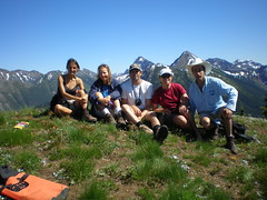
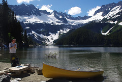
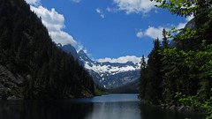
“Seven enthusiastic people set out on Friday afternoon, bound for a weekend in Manning Park. We all rode up in Chris’s amazing transformer van – everything from hot water to cook stoves to coolers to a bed was in there (although passengers slept in tents.) We camped just east of Manning Park, in a free and beautiful spot on the edge of the Similkameen River. Saturday had one person off fishing for the day, one person solo canoeing, and five of us heading up Skyline trail to Snow Camp mountain, in beautiful sunshine and completely blue skies. We had a few bizarre encounters with zombie-like people that were doing an ultra-marathon (100 km or 100 miles, depending on who you talked to!), including helping one woman down the trail to meet up with her companions. These people had run and walked for 30 hours or so, across the mountains and all night long, and we all agreed that it was pretty sad to see them so zoned out in such a beautiful environment. The vistas opened up to stunning alpine meadows, dramatic drops way down to the lakes, beautiful distant mountains, and an incredible variety of wildflowers. We took a total of 6.5 hours to hike this trail – hot but very rewarding, and the swim in Lightning Lake after was very refreshing. That evening five people drove back to the lake for a full-moon paddle, while two of us slept well! Sunday involved a lazy morning, and then canoeing and swimming in Lightning Lake again – enjoying the refreshing water and relaxing atmosphere. The evening was topped off by a good supper at the Manning Park Pub, and then a drive back to Vancouver in the evening sun. And enjoyable weekend had by all… Thanks to Chris for organizing, driving, and supplying the amazing extra equipment and comfort of the van.”

group on the summit

Lake Lovely Water 17/07/10

Erez at Lake Lovely Water:
“Rob M., Rob D., Jo-Anne, Tia, Ben, Michele and I spent a great weekend in Lake Lovely Water. There are several ways to get across the Squamish River to the trail head. We used Jay Bicknell’s jet boat service and took a 20 minute jet boat ride which was a very nice way to start the hike. Jay also made sure our adrenaline level was sufficiently high for the hike as he made an almost 360 degree turn in place just before reaching the trailhead.

I’ve read a lot about the extreme steepness of the trail and so I was expecting a difficult hike up. I also knew that not too many people hike it, and so I wasn’t sure it would be marked well. In reality, I found the trail to be quite manageable. It is steep in parts, but there are steeper trails. In my opinion, it is similar in difficulty to the trail up to Garibaldi Lake, which is longer, but less steep. It was also marked very well, and had very little deadfall. We took our time, and hiked for about 4 hours to reach the lake.

The lake indeed lives up to its name and reputation of being the Lake Louise of the coast mountains. Near the lake there is an ACC hut which we were not going to use. We peeked in and found the hut to be extremely well equipped with a gas stove, table, kitchen with cupboards, and even mattresses for the bunk beds. The people staying in the hut were nice enough to let us use its boats (canoe, and row-boat). Instead of hiking to the sand spit where we intended to camp, we took the boats, loaded our bags, and spent 10 minutes canoeing and rowing to the campsite. The snow level was pretty much at the elevation of the lake so part of the beach was covered in snow, but it was so hot outside, that it was actually quite refreshing. We set up camp, and planned what to do next. Some of us wanted to chill-out in the camp site and go for a (very chill) swim in the lake, and the rest of us decided to explore the western end of the lake by boat. The lake is even more beautiful when seen from the middle. At the western end, there is a large nice waterfall, and two of us scrambled up it to reach the point know as the “Russian Army Camp” – a very nice alpine bowl at about 1400 m surrounded by steep mountain faces and glaciers. We hiked down, and rowed back to camp.

The next day our group split up again. A few of us woke up at 6 am to climb one of the surrounding Greek giants. Our goal was Mt. Pelops. We pretty much followed the scrambling route described in Matt Gunn’s book ascending from its eastern face. The route consists of climbing steep snow slopes and a bit of rock-climbing near the end. We did not use ropes; two of us had ice axes and one of us had crampons. I had neither, and even though it was not a hard route, I would not try it again without both. It took us about 3.5 hours to reach the summit at 2000 m. We had almost perfect weather and the views were glorious. We lingered for about an hour up there, had lunch, and descended. Our descent was much quicker as we slid down on the snow most of the way. It took us only an 1.5 hours to return to the campsite. The rest of our group who did not join us climbing Pelops woke up later and hiked up to Niobe meadows which is at the beginning of our scrambling route. All in all, this was an excellent trip with excellent company.”

16 tant lake three

Statlu Lake 17/07/10

Michelle at Statlu Lake:
“Too much, the Magic Bus! Awash in a sea of emails, I would have needed to own the Magic Bus to accommodate the overwhelming response to this callout.

This Trek to the Undiscovered Country still took almost 3 hrs going as fast as possible in a well equipped 4×4. This officially 4×4 status road is *possible* for a car to take on (save for the last two short branch roads) at a much slower pace, but you’ll be muttering ‘Come on, come on’ and if you try and get anywhere at any speed your passengers will be shrieking ‘she’ll fly apart!’ as you exclaim ‘(We’ll) fly her apart then!!!!’.

If you disregard the significant driving effort, the hiking effort is minimal for the fine reward of Statlu Lake. Truly an area unlike what we would expect around here. Numerous high falls set in impressive box canyons (easy to see how there have been fatalities peering over edges). Seemed more like Pemberton – aquamarine lake in a rugged blueberry-rimmed bowl and old growth surrounded by gorgeous snow capped peaks. Though perhaps this should not be so surprising as you can drive these roads all the way through to Pemberton, if your 4×4 dares.

Due to time we opted to explore Statlu and the beautiful camp at its far end instead of ascending to the upper lake/viewpoint. Beautiful place to camp and explore. No wonder climbers scramble around this area. Thanks to the gentleman who built the new connector trail and bridges.

Note that the Harrison West FSR is posted as closing @ 25 km for bridge construction for 1 week sometime TBD between Aug 15 and Sept 15 – check the FSR road advisories for updates.”

Statlu Lake, July 2010

Mt Price 14/07/10

Andrew R. on Mt Price:
“Mike, Dan, Ellie, Ivana and myself left Park Royal at 8:30 am on our way to the Rubble Creek trailhead. We were met at the trailhead at 10:20 by Sharon. The six of us made our way up to the lake on an absolutely perfect blue-sky day. The Rubble Creek trail is now dry and almost completely snow-free all the way to the lake. We made our way past the Garibaldi Lake campground towards the Ranger Station where we would pick up the route to Mount Price. There is still a metre or two of snow on the ground beyond the lake, but it was very soft and melting quickly. The route to Price is tricky to follow (especially with snow on the ground) but fortunately the treed ridge is just open enough that we could see our objective and keep our bearing the whole way. On our ascent we found and lost the flagged trail repeatedly, but the group did a great job of route-finding as we slowly progressed up the ridge. A little before 4:00 pm we popped out of the trees on the ridge leading up to Clinker Peak and were greeted with seemingly endless views in all directions. Some of the group decided to make this their final destination and had lunch and soaked in the gorgeous views for the next hour. The others continued the ascent up the snow slopes with two of us reaching the peak of Clinker and one making the summit of Mount Price. We started down from the ridge at 5:00 pm. After a wet, post-holey slog back to the lake and a very long 9 km down the Rubble Creek trail, we made it back to the cars a little after 9:00 pm. The route described in Matt Gunn’s Scrambles guide is accurate and is the one we used. All in all, a fantastic, adventurous day with a great group!”

Golden Ears 13/07/10

Jennifer on Golden Ears:
“Getting an early morning start Valerie, Tamara, Jonathan, Darcy and Jen headed towards Maple Ridge and Golden Ears. Fortunately Valerie stepped in to drive as our driver did not call or show up for the hike (thanks Valerie!) The morning was clear everywhere except a big mass of clouds over Golden Ears. Our group set out despite the overcast skies, and after a lovely stroll through the forest, and scamper up onto the ridge, we were met with snow right down to the trees. Panorama Ridge didn’t give us any sense of its name as we wandered into a cloud to start our final push to the summit. When we got to the top, we were above the clouds and it was lovely and warm… but with no views. There were a brief couple of metres of scrambling but generally hiking all the way was possible. We sat at the summit trying Jedi mind tricks to part the clouds for almost an hour while eating lunch and relaxing. On the way down finally the clouds parted and we got wonderful views of the surrounding peaks and lake. Breathtaking as we ran/slid/butt scooted down the alpine sections of our hike. While not essential, ice axes did come in handy for some of us! Salmonberries galore kept us energized for the long hike out. Everyone hiked at roughly the same pace, and total hiking time was 5.5 hrs to the summit, 4.5 hrs back to the cars. We ended this long but fabulous mid-week escape with milkshakes and dinner at a local diner. Thanks everyone for a great Tuesday!”

Graveyard Valley 01/07/10

Chris in Graveyard Valley (southern Chilcotins):
“Getting to the trailhead for this hike can be a challenge. We made it in a slightly lifted 4wd Tracker with AT tires. 2wds will find the going ok until some dried mud flows on the descent to Tyaughton Creek campsite – still doable but you might scrap. If you get past a waterbar near the top of a hill about 500 m north of the campsite, you’ll be able to drive to at least 13.3 km past the campsite. Beyond this point the puddles get bigger and 4wd with good tires are recommended (later in the year, you might be able to push it for another couple km to the top of the big hill). We took the Relay Creek trail to the cabin then went up the Little Paradise Creek trail, over the pass to Graveyard and down to the large meadow where the main creek is. All the trails were frequently boggy with snowmelt and there were frequent creek crossings (many unavoidable). We had 2 nights of sub-zero temperatures and a mixed bag of weather – some rain, some snow, some hail and some sun. We explored many of the ridges around Graveyard including Elbow Mtn (climbing to 2450 m barely touching snow). Almost ran into a grizzly in Little Paradise (there’s also a large one in Relay – saw some enormous prints), heard some wolves calling and saw lots of deer and marmots. On the way out, we travelled down to Graveyard Cabin (which is showing it’s age – I’d opt for a tent given the choice) and back along the Relay Creek trail.”

Hector Ferguson Lake 24/06/10

Cam at Hector Ferguson Lake:
“A completed mission to Hector Ferguson Lake: need I say more? The plan was hatched for a quick over nighter for a short and easy hike to Hector. Three brave souls in attendance.

Thursday morning it was sprinkling a little bit but nothing out of the ordinary for Vancouver weather. Biked to 6.5 km mark, hiked to 9.5 km, forded Gold Creek twice and rejoined trail on east side. Forded again at 11 km to west side of Gold Creek, followed trail to bottom of drainage from 1502 and followed flags up. We missed the flags going to the NW out of 1502 creek towards drainage of HF lake. Bushwhacked up 1502 then turned west and joined up with HF lake. As many of the local hiking books describe the lake is pretty but the shore is far from inviting for overnighting. On Friday we followed the flagged route back to 1502 creek a much better route than what we took on Thursday.

Return distance 32-34 km, 650 m elevation gain, I measured 750 with my extra side trip.”

West Coast Trail 05/06/10

Su-Laine on the West Coast Trail:
“Yeah, we made it! Six days on the West Coast Trail went by quickly for our group, with one regret being that we didn’t make it a longer trip and visit the beaches of the south end. The southern 13 km of forest trail have no redeeming qualities whatsoever, and the next 9 km feel almost as pointless except for the satisfaction of having several dozen ladders and countless bottomless mud pits behind you. Despite improvements over the decades, this is still a tough trail. Good things to have are sturdy well-broken-in boots, tall gaiters, bicycle gloves, two poles each, and microspikes for slippery logs. You need balance and agility to get anywhere. After two long days trudging through the south end, the lovely beaches and faster hiking conditions of the north end were a joy. It’s a beautiful trail for gazing into tidepools, for swimming in creeks and waterfalls, and for exploring seaside rock formations.

As we’d hoped, the trail was comfortably uncrowded, and finding good camping spots and room in the metal bear boxes was no problem. The mice are definitely back, especially at Tsusiat Falls – don’t delay in getting your food to into the bear boxes in the evenings! One other thing to know is that Telus cell phones work on the trail but Fido ones apparently don’t.

We got to know our fellow south-to-north hikers a bit, enjoying their company at shared campfires and at a brilliant brunch at Tides and Trails restaurant on day six. Hiking times were very long on most days and there wasn’t much free time, but we took a break for burgers at Chez Monique and spent some unhurried time at the beach, and entertained ourselves by building a bridge across the Darling River. We managed to see some whale spouts but not much else in terms of rare wildlife. There was a sense that there is more to the trail than we could see that week, giving all three of us some desire to go back.

P.S. The Parks Canada staff said July and August are fully booked and that there are still some reservable dates in June. September is reportedly an excellent and uncrowded time to do the trail.”

Ladder

Gate Mountain 13/06/10

Steve on Gate Mountain:
“Five of us set out to tackle this one, but our luck on this trail was not great. First off, the trailhead sign shown in every online resource is gone and replaced by a plastic bag wrapped around a stick. 103 Hikes also quotes 5 km from Alexandria tunnel, but it is actually closer to 3.3 km. But once we figured that out, up we climbed. Markings were “ok” with basically no more mishaps than the average hike of his type. Unfortunately the weather turned at the top (it was hot and sunny below). As we got to the ridge, the bushwhacking began. Not as bad as some places but it did slow us down. Then we ran out of markers, and the snow started to pile up.

Combine all of those elements and the fact we had reached our turn-around time, we decided to cut it short only about 85% of the way to our goal, and having never actually seen Gate Mountain itself (even from a distance). In fact, 103 Hikes mentions most people don’t go all the way, to which I ask: why do this hike? As we descended, the weather improved again! If this had happened up top I think we’d have pushed on for 30 more minutes.

Now, here is the gross part. After actually discussing that Fraser Canyon is a tick infested area, Michelle was bitten by one and it was burrowing into her skin, so after a 2 hour detour to the Chilliwack Hospital emergency room our trip came to a close.

On the whole I would not recommend this trail. The First Brigade trail next door is more interesting (but watch for ticks!).”

Panorama Ridge 13/06/10

Chris M. on Panorama Ridge:
“Starting out, the clouds (and rain!) didn’t look promising. But having an Alex sunshine guarantee, we didn’t worry. The first 5 km of the Rubble Creek trail are snow free. The meadows, lake & mountains are still covered. With help from Evgeny’s GPS we made our way to the west end of Panorama Ridge. It was a little steep but the snow was good. Valerie used her micro spikes, while the rest of us used an ice axe. Snowshoes were not needed all day. About 2/3 of the way up the clouds and wind increased. We couldn’t see anything. However, Irina said the weather report called for sun in the afternoon so we continued. Sure enough, around 12:15 the clouds started to break and view opened up. Everyone was happier! We took the standard route down with some shortcut-fun downhill glissading. Then made our way across the meadow and back down the trail. Finished up with dinner at the Watershed Grill in Squamish.”