
Peter A. on Eaton Peak:
“Bahman, Michael, Eric, Thomas, Ben, Irina, Evgeny, and I tackled the tough hike and scramble up Eaton Peak’s west summit. The first 4 km of the trail is a 915 metre climb up to Eaton Lake. The trail was well-marked and generally quite wide. The 3 log “bridges” across Eaton Creek were in good shape, and because it was hot and dry, no problems with the logs being slippery. We reached the beautiful lake in approx 2 hours. From the lake, the route is a bushwhack through forest in a south-east direction to arrive at alpine just below a prominent cliff which can be seen from the lake. To start our bushwhack, we found an obvious trail behind the campsites that led uphill to a small boulder field. Across the boulder field there was a piece of flagging tape. Beyond that point, no tape was visible, and so I led our team to the east on a gradual ascent through very dense trees and bush, not wanting to cut too steeply uphill. The correct direction was to head more directly uphill (south). We eventually found Eaton Creek above the lake, and because the water flow was manageable and the rocks and moss not too slippery, we climbed up the creek to a plateau. We then followed a dry creek bed up a steep gradient and arrived at the prominent cliff face. We traversed below the face, and then climbed a steep boulder field to attain the north edge of the basin in front of Eaton Peak. Access to the west ridge was an obvious notch along the ridge. After crossing the boulder-filled basin, we scrambled up a steep ramp leading to the notch in the ridge. The start of the ridge scramble was very difficult as we crawled and climbed our way through krummholz-overgrown boulders. However, as a result, we avoided the first crux referred to in other trail reports. The second crux (the chimney) was challenging, but fun as the rock is very stable (our experienced alpinist, Bahman, assisted those who needed some suggestions for foot and hand holds. We also fixed a rope for support). Throughout the ridge ascent there were mild to moderately exposed ledges and slabs, and straddling the boulder in the “au cheval” move provided lots of laughs. The summit was beautiful, and our visibility exceptional. Baker and many other notable mountains were clear. Our time from trailhead to summit was approx. 5 hours. On our descent, after carefully down-climbing the chimney crux, we dropped down the steep gully that lies immediately to the west of the ridge and followed this almost to the notch where we had first gained the ridge. Then, during our descent of the boulder fields to the creek, we spotted a black bear feasting on berries. Thankfully, it was on the other side of the fields. We also feasted on huge blueberries and huckleberries. Since the water in the creek was relatively low, we avoided a lot of bushwhacking by descending the creek as far as we could, then bushwhacking west to the campground on Eaton Lake. We left the lake at 7:20pm, and ended up using our headlamps to arrive back at the parking lot. Total time was 11 hours. An outstanding hike with technically challenging scrambles, and a great group!”
Category Archives: Scramble
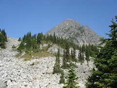
Mt Grant 07/09/09
Ahmad on Mt Grant:
“We had to turn back. I had myself no chance to continue. The fresh snow was a formidable barrier that we couldn’t pass through. I didn’t expect it and I was under-prepared for it. It was a good reminder of what frozen feet meant.
Eaton Lake trail was in good condition as it was when I did it 3 months ago. The bridges were still not repaired. The first log was wet and more slippery but doable with good care. The fork to Grant was just after the broken bridge at elevation 1300 m. We followed the south edge of the ridge. There was no trail defined. Some old ribbons and cairns from time to time till we got to altitude 1400 m. The ribbons became abundant in most places. There might be another newer trailhead closer to the third bridge.
The trail is generally bushy before the steep section. I was at the back all the time and I got soaking wet from all the water was on the leaves. The steep slope starts at 1550 m. The rocks were wet, cold, and slippery. We managed to negotiate them till we got to 1850 m.
I believe this hike would be have been a pleasant and quite scenic in good weather. I think the scramble would have been also easy.”
Williams Peak 30/08/09
Peter A. on Williams Peak:
“Hurrian, Siegfried, Nikita, Alex, Lana, Carol, Dave, Thomas and I successfully climbed the relentlessly steep Williams Ridge in 30 degree heat, braving wasp stings and enjoying a bounty of huckleberries and blueberries. Approx 1000 m elevation gain straight up: like the Grind, but higher and without steps. After another hour of hiking along the beautiful, rolling forested ridge, we ascended “the first knoll” for lunch, which sits across a rocky basin from Williams Peak. The trail from the parking lot to this point was clearly marked and well-maintained. Beyond were various routes for ascending the peak.
After lunch, six of us set off to summit the classically-shaped summit horn: the heat and blisters took their toll on three of our party. We followed Gunn’s route, beginning by descending steeply a lot of vertical into the large basin below the mountain to avoid cliffs. From there it was a long, hot ascending traverse across a number of boulder fields and ridges to reach the base of “the ramp”. Though steep and dusty, the trail up the ramp was clear and contained few loose rocks, providing easy access up and over the south ridge of the peak. A short traverse dropped us into a large, prominent gully that led straight up to the summit. Take time to note where you enter the gulley so you can easily find your exit and route back to the south ridge on your descent. The gully is very steep, but mostly grassy with lots of foot-holds. Since it was hot and dry, it was just a long grunt up: I wouldn’t want to do this up or down when it’s wet and slippery. It took us 1.5 hours to summit from the first knoll.
Views on top were hazy but spectacular. The Peak is surprisingly broad, although the drop-offs are super steep. On our descent, on top of the south ridge, poised to start our way down the ramp, we found a series of cairns leading off to the right. We followed these, which took us on a gentler descending traverse, keeping us higher above the basin and many (but not all) of the boulder fields. Cairns led us just below the cliffs of the second knoll, until we intersected with our original route directly below the first knoll, but much higher above the basin. Our return to the first knoll via this route took a little over 1 hour.
The long, descent to the parking lot was happily broken up by sessions of berry picking and eating. Round trip time was approx. 9 hours. The hike was physically demanding (no water sources from the ridge onwards), but the scrambling was technically easy. A great group and an outstanding hike.”
Locomotive and Face Mtns 29/08/09
Tim on Locomotive and Face Mountains:
“Tim and Alex scrambled Locomotive and Face Mountains. The Hurley River Road is rough but very doable in a LC 2WD. The hike to Semaphore Lakes is an easy 60 minutes. Locomotive is a tiring but easy 5 hr scramble. The route described in Matt Gunn’s book is fine. But there is a slight variation (turn left at the upper lake to avoid the snow slope) that is less work and more fun. We ran into the celebrated Mick Range at the trailhead and he suggested this variation. The view from the top is very good. Current haze from wild fires reduces visibility. Face Mountain is a more difficult 7 hour scramble. But the payoff is superior. It is an exciting climb with some challenging terrain. Matt Gunn’s book provides a very good description that, if followed carefully, keeps you out of serious danger. Helmets are essential. The summit is a steep slab with a very scary cliff on the other side. The view from the top is almost unbeatable. In particular the Train Glacier is an amazing expanse of ice with a rather nifty waterfall at the snout. Both peaks are surprisingly snow free at the moment.”
Cayoosh Mountain 18/07/09
Ahmad on Cayoosh Mountain:
“The trail name means a horse and it is said that it is named after the tribe chief’s horse collapsed after passing through this area. Whether it is a legend or not, the trail is extremely hard on the knees. The majority of the trail is boulders. There is almost no flat section except the first ~3 km logging road.
Our hike took almost 12 hours in total and we couldn’t finish it. The majority of our approach to the peak was loose rocks. We were 6 in total and 4 changed their mind not to continue. The two of us took a slightly wrong approach close to the false summit and it was a dead end. I wasn’t able to find any way to get to the right way from where we were. There were exposed cliffs from both sides that we both didn’t feel comfortable to continue. We had to go down significantly to go to the right way. We didn’t have time for it. It was frustrating to go through all this without a result. So my suggestion is that you camp at the second, small lake and take your time on the next day. However, it is possible to be done in one day if you have good knees.
The views were great but for me I am done with this trail.”
Crown Mountain 11/07/09
Su-Laine on Crown Mountain:
“Ow, my legs hurt. Other than two sections of moderate scrambling, the statistics on this one make it look like a moderate 9 km hike from the top of the Grouse Mountain Skyride. There are several climbs and descents each way, so although the overall elevation gain is only 455 m, in total you’re probably climbing over 1000 m, and I found it a lot more tiring than another 1000+ m hike I’d done a few weeks ago (Eagle Bluffs). Maybe it was the hot sun, or maybe the fact that the trail requires so many damned deep knee bends for smaller people like me.
I’d posted this as a 5-6 hour hike but it ended up taking us about 8.5 hrs, including breaks and half an hour off-trail when some of us missed a marker. The off-trail part took us down some slippery rocks and wasn’t fun; other than that the scrambling was fun. It was good to be in a group so we could spot each other and learn from others’ techniques. The summit is snow-free but we had to cross a couple of patches of packed snow lower down where hiking poles were useful.”
Yak Peak 05/07/09
Ahmad on Yak Peak (instead of Mt Cheam & Lady Peak):
“There wasn’t much snow on Yak’s basin and there was no need of using ice axe. However, poles will be helpful. The snow was packed in good conditions in most sections. I scrambled up on the rocks rather than going up on the snow. The rocks allured me to be a good way. A mistake that I quickly realized. The rocks were too loose and they lack hand holds. I scouted several directions but each led to a close end or requires a difficult and lucky move. I managed to finish it at the end after more than 30 minutes. It wasn’t a good way. It was difficult and I ended up alone on the summit. On the way back, I found the proper route which was about 5-10 m away. It was fairly easy. It goes on the snow that cover the ridge. The snow seems to be steep but it is not exposed and it is actually fun. The false summit also represents a nice alternative. The other three people that I was with, chose it and they were satisfied with the views. There were also many mosquitoes and they got even more the higher we got and didn’t get rid of them even on the summit.”
Tszil Peak 21/06/09
Ahmad on Tszil Peak:
“A nineteen-hour trip and 10:40 hours on the trail. I can tell you confidently it was a long day. My initial perception that the Joffre Lakes trail was a piece of cake but I found it fairly hard and it was not the quality that I thought – many roots, rocks, and boulders. We got to the bridge that leads to Joffre Campground after 2:20 hours where we had our 1/2 lunch break. All lakes were unfrozen. The trail was also clear from any snow. I was pleased to see Tszil has a trail. I also found it in a better conditions that the Lake trail although it is not well defined as the other one. I don’t think it goes all the way to the summit. The trail eventually climbs on a narrow ridge that was about 100 m high and in some portions was less than 1 foot wide. We got to Tszil-Taylor col at 4 pm. We still had 230 m of elevation gain to do. It was a whiteout. A large part of the slope was still covered by snow. We decided to give it a try. It was not easy. Some rocks were slippery and some of the snow was not in good conditions. We summitted at about 4:55 pm. On the way back, we chose the gully with the snowfield. It was quicker and more fun. This is my second time of taking my snowshoes on a tour without using them.”
Brandywine Mtn 06/06/09
Chris M. on Brandywine Mountain:
“The 4×4 access road was snow free, unlike the top part of the trail. Glad to have bypassed it. We followed the last branch and quickly entered the meadows. Except for the creek, it is still covered in snow. A collaborative effort in route-finding got us up to the ridge where we set up camp. A site meant for the gods – the views in all directions were fantastic, especially since we seemed to be in a pocket of blue sky. We camped on snow, but rock outcroppings provided a nice place to relax and eat. We went for the peak in the morning with 3 of us reaching the 2213-m summit. Fairly easy scrambling involved. Easy descent and nice drive back to Vancouver by 3 pm. Thanks to Erin, Dorothy and Stacey for making this an excellent experience.”
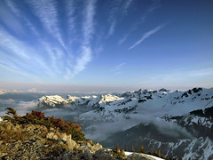
Overlord Mountain 27/09/08
Ahmad on Overlord Mountain:
“What amazing views from Overlord! The ascend was harder than I expected. Top of Refuse Pinnacle was covered by fresh snow and its slope lured us to traverse it. It seemed it was possible from looking at it from a distance and the topo map. We traversed a long way on a series of small gullies and ridges with many loose rocks till we reached a point, we found that it was hard to continue. We decided then to climb up to its top which was a hard climb but then we were relieved to find that its narrow top ridge was a much better option. The snow made it slippery but I think if it was dry, it would have been easier. The rest of the way was easy. It took us 4 hours to go up and 3 hours to get down from Russet Lake. I also find Whirlwind Peak provides nice views and it could be a destination by itself if you don’t have the luxury of time. It is also an easier option than Fissile Peak. On Saturday we met a few small groups camping on Russet Lake including two former members from Wanderung. The four of us had an excellent weekend. No ice axe was needed to get on Whirlwind ridge. Thanks for Tim and David for their information and tips.”