
Michelle on Dog Mountain:
“The -7 / -12 with wind chill factor definitely had us wondering and we were definitely a little on the cold side starting out (our toes were already cold from just standing outside the shopping mall!). But instead of bundling up more, we quickly heated up on the trail and inevitably began the customary strip routine by the time we hit First Lake. However, after reaching our end destination we didn’t stick around to enjoy the sunny view for very long: though the winds were calm it was just too darn cold to sit around for more than a cup of tea and quick nibble. The winter route is now marked and well trodden (although a couple of alternate routes have also been stomped out past First Lake). Good snow coverage save for a few steep, exposed, iced-over root patches not yet filled in. Good parking lot coverage too (of the vehicular type) as to be expected on a sunny day.”
All posts by andy
Alpen Mountain 14/12/08
Chris on Alpen Mountain:
“Cara, Darcy, Dean, Mathieu, Roberto, Siegfried and Tania joined me in a search for the Hidden Valley Cabin on Alpen Mountain just east of Squamish. The Mamquam River Main (not the same road as the Mamquam Road that accesses the Elfin Lakes trail – this one is unsigned and just after the parking for the Chief) seems to see a fair amount of local traffic and was drivable to the Alpen Rd. The gate here was open so we drove in and parked just short of the first waterbar (200–300 metres up). Despite ferocious winds on the 99 and in Squamish, we encountered only light breezes even in exposed areas. But temperatures averaged around -10 C. We followed the main road but made a wrong turn about half way up (there are a lot of spurs) which lead us to a dead-end. After an attempt to cross-country to the main road, we gave up and back-tracked to the main road. Part of our party headed higher but still didn’t reach the cabin (locals said that it would have taken 4 – 4.5 hrs from the bottom). The snow varied from a couple inches at the cars to 2 feet of weightless powder around 1200 m.”

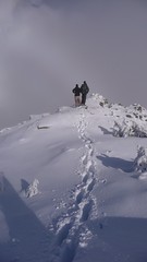
Cougar Mountain 07/12/08
Chris on Cougar Mountain:
“Albert, Alex, Cara, Jamie, Nancy, Ribeka, and Tessa joined me in a snowy exploration of the western flank of Cougar Mountain. The road to Cougar Mountain (16 mile creek road) leaves Hwy 99 just after Green Lake. We encountered snow fairly early and the potholes had turned into slushy ponds (doesn’t look like this road is plowed but sledders probably use it later in the year). The hill after the bridge took some effort to drive up and we slipped and slid up to the stables to park. To get to the cedars from there, follow the road up taking a right at an obvious fork and sticking to the main road until you start to encounter faded signs and follow those. The road turns into a gentle trail and we found ourselves in the cedar grove about an hour after leaving the cars. We then headed off-trail following the creek uphill. We topped out at 1200 m overlooking a small pond and temperatures stayed above freezing for the whole route.”

Brothers Creek 30/11/08
Michelle at Brothers Creek:
“We stayed dry under the canopy (and the weather stayed mild), but the trails were wet. The first uphill section of the trail from the lower trailhead is currently a small stream and squelchy mud was under foot most of the day (although shallow and only of consequence to boot soles and pant leg hems). Upon return we snuck a view of Burrard Inlet and Stanley Park immersed in a bed of sunset fog with the Lions Gate just peeking out of the top and the downtown core rising in the background before popping back onto the road by our cars and standing in the street to stare at the city bathed in pink. The neighbours may have wondered though as our large little tour group just stood on the street corner gazing off into the distance… Enjoyable day and good company as always.”
Mt Harvey 22/11/08
Ribeka on Mt Harvey:
“Incredible day for a crisp November ascent to the peak of Mount Harvey. Ahmad, Tamsyn, Trevor, Aaron and I enjoyed a snowy, steep hike to some beautiful views of Howe Sound and the surrounding peaks. Hit patches of snow right from the start of the Mount Harvey trailhead and ankle deep fluff within the first few hundred metres, right up to the ridge. Enjoyed some incredible sunshine and views for a quick snack stop and orange seed-spitting contest. We continued along the ridge in knee deep snow and scrambled to the top for some more peek-a-boo views of the water below. A foggy lunch and a short rest before slip-sliding our way down. Cedar bark tobagganing, snowball fights and trail flag lawn darts. Good times.”
Killarney Lake 16/11/08
Merewyn at Killarney Lake and Dorman Point:
“Another great Bowen outing! We ended up a boisterous group of 13 (I know, big group but since I got so much response and it’s an easy transit hike I decided to extend the number just a little). We all had a great time exploring the leaf-covered trails on Bowen (they were damp but not very wet or muddy though some of the boardwalks were a bit slick) and then chatting it up over drinks and a late lunch (early dinner?) at the pub post-hike. The weather was a bit grey and foggy but to my surprise, there was no rain (it always rains when I do this hike!) and we did get some views from Dorman Point. Great company, great fun!”
Diez Vistas 16/11/08
Michelle at Diez Vistas:
“The weather people got the days reversed (Sunday and Saturday got each other’s forecast). The rain held off and it was nice and mild, but our band of 6 had 10 spectacular view points of … fog! It promised to clear at lookout 0 as we watched the horizon line and cloud separate, but the ridge became re-enveloped (although we managed to sneak a view of Baker from the Eastern view point). Instead we enjoyed the tranquil misty rain forest trail in all its mossy glory. We surprisingly had very little company on the trail even though the trail was in fine condition and the first parking lot was full (guess everyone was down on the lower trails). Note: Construction is posted as blocking the Eastern side of Trout Lake and the short cut junction at the Northern end of the trail by the log crossing isn’t marked – we took the long way down right to the end of Diez Vistas at the end of Trout Lake where it bottoms out onto the road. Six hours round trip including extra West to East viewpoint loop laps. One quart of ice cream down, 14 to go.”
Phelix Creek 15/11/08
Chris at Phelix Creek:
“Andrew, Cara, Gloria, Lucy, Midori and Ribeka joined me on a rather wet trip up to the Brian Waddington hut in Phelix Creek. The Blackwater Road was in good 2wd condition with minor potholes and a small amount of slick mud. The Phelix Creek Road is rough 2wd for a couple hundred metres before it becomes fully 4wd at the remains of a rock slide – park 2wd vehicles at a sign warning about mudding about 200 m up the road. We all piled into Andrew’s Jeep and drove to the end of the road (almost as fun as the Lone Goat trip). The trail is well marked with reflective orange metal tags and snow patches started early (1200 m). It took almost 3 hrs to hike / slog / snowshoe to the hut (only 4 km). There was up to 2-3 feet of snow in places but the lake was slushy and not yet frozen (1700 m). Temperatures never dropped below freezing even at night and it rained / drizzled almost continuously. The cabin is outfitted with only a small (size of a large pot) portable white gas heater which did little but fill the hut with fumes so it was soon extinguished. The hut was clean and, because the surrounding hills often have high avalanche danger, provided with much reading material (check out the outhouse log book) and many sets of playing cards. By morning about 6″ of snow had melted off and several people headed up the valley for a bit of exploring before we headed back to the trailhead. The hugely variable freezing level makes this time of year tricky to go hiking.”
Lynn Canyon & Seymour River 02/11/08
Merewyn in Lynn Canyon and down by the Seymour River:
“Well, the forecast for this day was a little off. We got sprinkled on a little on the trail but we also got a period of cloudy sunshine as well. The group had a very pleasant time exploring the Lynn Canyon and Seymour Demonstration areas. We all had a bit of a scare watching from a bridge above the canyon as a kayaker got caught on some rocks, struggled to regain control, submerged himself face-first in the water, and finally had to roll out of his boat and swim down through the rough patch to re-join his boat and his friends at the other end. But he got through okay and so we continued on our loop back to the suspension bridge where we had started.”
Black Mountain 26/10/08
Michelle at Black Mountain:
“Eleven of us tromped around the trails of Black Mountain with perfect weather, superb views and CoLoUrFuL conversation. Construction is in full swing, but the re-route signs are easy to follow towards Yew Lake and Black Mountain. The new trails are wide and well defined, although after the switch backs and gaining most of your elevation, there are many half frozen ‘mud pit’ sections with which a few members got well acquainted with. On the route we chose (multiple options available) we were quickly rewarded with great views of the Tantalus Range and the Lions from presumably the north summit before dipping back into the forest on an up-down type trail. We passed numerous tarns – quite pretty little lakes before reaching the impressive Eagle Bluffs at the south summit with rewarding 180-degree views.”