
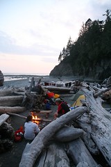
Pablo finding all Diez Vistas:
“When I posted the call-out the forecast was sunny, but next day changed to rain. It was raining when we met at the meeting spot, but it stopped before the five of us started hiking. I don’t know why people complain they cannot find the 10 vistas. They are clearly marked Vista #1 to Vista # 10. That doesn’t mean they you will find 10 view points, but the 10 vistas are there. Actually, there are 2 viewpoints before the 10 vistas that are way better. The group was great, we keep a good pace and allowing lots of time to take pictures, but no-one was either running nor staying behind, in fact we stayed together the entire hike. We couldn’t finish the trip without doing the must stop at the ice cream place at the entrance of the park.”
All posts by andy
Richmond Dykes Cycling 18/06/09
Michelle cycling the dykes in Richmond:
“Much more than dykes – a surprising little gem of a bike ride with plenty of fodder for shutterbugs. Diverse and interesting scenery: old river homes along Finn Slough, treed riverside paths, views of Cypress/Grouse/Seymour side-by-side-by-side, cornrow farm fields, shipping container fields, industrial areas, wooden dog populated park, historic London Farm, fruit tree co-op, beautiful homes/gardens/waterfront, historic Britannia Heritage Shipyard, character community Steveston, scenic Garry Point Park and thanks to local knowledge of local crew member Susan- just beyond on the West Dyke- marshlands, water and sky to infinity. A beautiful sunbathed & sunset after work ride with a good crew.”
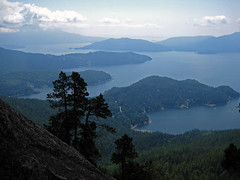
Alpaca Peak 14/06/09
Ahmad on Alpaca Peak:
“The trail has three parts: walking on a road, semi bushwhacking following ribbons but no trail, and hiking a ridge which is the most rewarding section. Although there are many ribbons, there are a few sections on which there are none. You need know how to orient yourself. There are a few steep sections on the ridge but not too steep. You don’t need snowshoes at this time but there is still snow on the ridge. We were also lucky with the weather. It was cloudy on the way up and cleared up on the way back which helped to keep the snow not too slushy. The entire hike took us about 10 hours. A long day but worth it.”
Cairn and Blustry Mtns 13/06/09
Chris on Cairn and Blustry Mountains:
“It was just Cara and I on an initial exploration of Cairn the Blustry Mountains in the Clear Range. The McGillivray FSR is immediately north of the easily-missed unsigned McGillivray Creek crossing on Hwy 12. The sign is hidden by the cattle gate (unlocked). We followed the directions in the Lillooet hiking guide book (turn left at the 3-km mark, follow the main road to the road end at 9.4 km) encountering 2 other gates along the way. The surface is 2wd but there is some minor rutting and lots of rocks. And there were cows on the road on the way back. The trail is easier to follow up than coming back down (many cow trails leading everywhere). Water is important while hiking in this area and McGillivray Creek seems reliable for at least 2/3 of its length – you lose the better part of the flow near a horse camp. It took us 4 hours to hike to a camp site just beyond the McGillivray headwaters at 2100 m. Water here probably dries up later in June. On the middle day, 8 hours was just enough to traverse Blustry (sometimes on a strong horse trail) and reach the top of Cairn (2300 m) – barely time to sample the vast possibilities of the area. The ridge just to the south of Blustry looks nasty but there is a safe route weaving between the ridge teeth (avoidable by dropping down into Pocock Creek headwaters). By July, this area will be filled with cows and the water will be gone.”
West Coast Trail 09/06/09
Heather on the West Coast Trail:
“Ribeka K, John A, Bob M, and Heather W did a glorious 9 day backpacking trip along the classic West Coast Trail of Vancouver Island from June 9-17. No wonder this hike is rated as #1 in the world – it is as stunningly gorgeous and amazing as everyone says. Our adventure included hiking pebble beaches, wandering around sandstone benches & cliffs, climbing up and down ladders on slopes in the forest, slipping along muddy trails and broken boardwalks, ambling on sandy beaches, negotiating cable cars, swinging on suspension bridges, and passing lighthouses, caves, arches, and rocky headlands. We marvelled at the many waterfalls, tide pools, whale sightings (four days!), sea stacks, sea otters, martins, bald eagles, sea lions, windswept trees and wildflowers. The trip included great campfires every night, heavy packs, jumping into amazing swimming holes, fantastic company, stupid amounts of food, and intense debates over jelly bean flavours. We were very lucky to have no rain for 8 days, and the fact that it hadn’t rained for almost a month resulted in mud only being up to our ankles instead of over our knees! Other highlights included the milkshakes & burgers in Bamfield, having the local water taxi drop us on a deserted beach for our last night camping, and AMAZING whale watching on the boat that took us back along our whole hiking route to Port Renfrew. If you go, do it before June 15 or after Sept 15, and don’t forget the marshmallows!”
Mt Killam 07/06/09
Steve on Mt Liddell Killam:
“After consulting with the Gambier Island Conservatory, we switched from our plan to hike Mt Liddell (overgrown and 2 bridges out), to the one favoured by the latest version of 103 Hikes, Mt. Killam. This trail was straightforward to find and the signage above average. The distinctive orange/silver pattern made us confident we were on the right track, and when no marker was in sight, there was plenty of trail tape. However, there was quite a bit of windfall and dry, dry, twigs to step over (no snow at all). The viewpoint was the best I’ve seen on Gambier, with views of Keats, Bowen, the Paisleys, and Langdale ferry terminal. A big thanks to a good, evenly-paced crew (5 in total) that got up super early to accommodate the ferry schedule (we hiked it in less time than expected). The weather was far better than expected as was the carrot cake from the Gambier General Store”
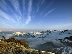
Brandywine Mtn 06/06/09
Chris M. on Brandywine Mountain:
“The 4×4 access road was snow free, unlike the top part of the trail. Glad to have bypassed it. We followed the last branch and quickly entered the meadows. Except for the creek, it is still covered in snow. A collaborative effort in route-finding got us up to the ridge where we set up camp. A site meant for the gods – the views in all directions were fantastic, especially since we seemed to be in a pocket of blue sky. We camped on snow, but rock outcroppings provided a nice place to relax and eat. We went for the peak in the morning with 3 of us reaching the 2213-m summit. Fairly easy scrambling involved. Easy descent and nice drive back to Vancouver by 3 pm. Thanks to Erin, Dorothy and Stacey for making this an excellent experience.”
Levette Lake 06/06/09
Su-Laine at Levette Lake:
“Lots of changes to this trail since the 5th edition of 109 Walks came out in 2002! Forget about trying to count how many private roads emerge on the left on the way to the lake, and just look for the trail entrance (which no longer looks like a road) that’s immediately before the red metal gate and next to the parking lot. The Skyline trail has few red triangle markers described in the books, but lots of yellow round ones now. And the “Blue Trail” connecting the Skyline trail to the road leading to the parking area appears to have been reopened, which considerably shortens the amount of time you have to spend walking on the road. However, the 109 Walks book was very useful on this trip, especially with its detailed map that we found to be accurate.
The trails we used were dry and, despite rumours on the Internet that they’re badly overgrown, well-maintained except for at least one small bridge that looks like it might collapse any day. A few of us walked over the dry creekbed instead of taking the bridge. Even in dry conditions, you need boots with good tread on this trail though. Views of the Tantalus mountains were good, especially from the shores of the attractive Levette Lake itself. Few wildflowers were blooming, but the forest itself, with its soft floor, was lovely to hike through.”

Brohm Lake 06/06/09
Michelle at Brohm Lake and Forest:
“This 2 for 1 hike offered a pleasant casual forest hike on a beautiful sunny day. Though the entrance to Brohm Lake Interpretive Forest doesn’t have its own sign/turning lane (unlike Brohm Lake) it’s easily spotted: after Alice Lake look for a yellow gate on your left with a signboard map right next to it. Signage/trail markers were excellent all along the two inter-linking trail systems (and nary a blow down!). The “fire lookout” offered by far the best views and proved to be a highlight and a most suitable lunch spot. The upper High Trail and Western shore trail of Brohm Lake (a surprisingly large and enjoyable lake) were the most pleasant in both terrain and lake views from above, although the easiest water access points were on the eastern bluffs close to the lake parking lot on the #99 side. You never know what’s hiding just off the shoulder of the highway.“
Lindsay Lake 06/06/09
Robert on the Lindsay Lake trail:
“Our ambitious group of 12 hikers was successful in hiking the trail to Lindsay Lake and Eagle Peak. All the weather forecasts pointed to a sunny day, however we were in the clouds most of the day which provided its navigating challenges. We started the trail from the Buntzen Lake parking lot at 8:30 am and took the route up along Buntzen Creek to El Paso Junction, 100% snow free. From there you have a choice to take the right trail through various lakes or take the left trail to Lindsay Lake. We took the left. About halfway on this trail we hit some snow, which was easy to walk on and finally reached Lindsay lake, about 3.5 hours after our start. Even though it wasn’t sunny, there was a certain atmosphere of being in the clouds and only being able to see a few metres in front. From Lindsay Lake, we took the only route to Triangulation Point and then on to Eagle Peak. It was also here that we met a hiker from Moscow who was lost so we added another member to our group and will soon recruit a new Wanderung member. I would only recommend doing this trail when the weather is clear because in the clouds it was difficult to see the markers since visibility was extremely limited. When we arrived at Eagle Peak we decided to take the Swan Falls trail to the bottom. This trail warns of being steep and obstructed but it actually isn’t bad at all and you come out of the snow very quickly because you lose elevation so quickly. A walk back for half the group along Lake trail and Powerhouse Road for the other half made the end to a long day! Thank you for all your teamwork and eagle eye (no pun intended) scouting for markers.”