Chris on the Scudamore-Van Horlick divide:
“Cara, Dean, Dorothy and I tackled the Scudamore – Van Horlick divide for 3 days. The Van Horlick road is in decent 2wd condition – some minor potholing so you can’t fly along but nothing bad. The Morris spur is in rougher shape with minor rutting and the alders will challenge your paint job. The Morris East spur is overgrown while the Morris West is in great condition. Unfortunately, you can’t drive either because the bridge at 11km from the Duffey has been pulled (leaving some logs but no bridge deck) and you have to walk the 4 km to road end. At the very end of the road, a faint trail starts down towards the end of the Morris East road but quickly disappears. Just continue down in the same direction through the slash, cross the stream at the bottom (there’s a log about 100m upstream from where you hit it) and climb the slash to the alder-choked east road. A sparsely-flagged and sometimes faint trail leaves the end of this road towards the valley end and can be followed to the col. From here, we climbed the south side of the east shoulder to meadows where we camped. The mosquitos have moved beyond epic to positively biblical. On the middle day, we sidehilled to the south and climbed to the North Stein ridge just south of Elf and came back over that peak. The going is a bit scrambly near the top. We dropped down into another saddle and back onto a great ridge with good views. We returned along the benches on the east of the ridge (very little snow in an area that historically has a fair amount even into August), through the saddle and back to camp. On the last day, we ventured into the North Stein meadows and returned to the west road by crossing the creek higher up and bushwhacking to try to avoid elevation loss but you are forced to follow the creek down anyway.”
Tag Archives: 3 days
Marmot Gardens 11/07/09
Chris in the Marmot Gardens:
“Perhaps it was the late callout but I got no takers so it was just Cara and myself on this trip to a remote part of the Stein. The Blowdown Rd is easily 2wd-able until just after the 9 km mark. There’s a waterbar in the middle of the hill around 9.5 and a couple just before the 2wd parking area at 10.3km which shouldn’t be an issue for the average 2wd. The portion of the road up to the Blowdown Lake 4wd parking area seems to be in slightly worse shape than last year but we got my micro 4wd up it. From there to the pass is actually in better shape and it would be no problem to drive a 4wd up to the switchback 20 m short of the pass if you get up to the lake parking. The lupines are in full bloom around the lake and in Marmot Gardens. In the gardens, the mosquitoes were epic and the horseflies started showing up. We also saw a grizzly and, of course, numerous marmots.”
Cairn and Blustry Mtns 13/06/09
Chris on Cairn and Blustry Mountains:
“It was just Cara and I on an initial exploration of Cairn the Blustry Mountains in the Clear Range. The McGillivray FSR is immediately north of the easily-missed unsigned McGillivray Creek crossing on Hwy 12. The sign is hidden by the cattle gate (unlocked). We followed the directions in the Lillooet hiking guide book (turn left at the 3-km mark, follow the main road to the road end at 9.4 km) encountering 2 other gates along the way. The surface is 2wd but there is some minor rutting and lots of rocks. And there were cows on the road on the way back. The trail is easier to follow up than coming back down (many cow trails leading everywhere). Water is important while hiking in this area and McGillivray Creek seems reliable for at least 2/3 of its length – you lose the better part of the flow near a horse camp. It took us 4 hours to hike to a camp site just beyond the McGillivray headwaters at 2100 m. Water here probably dries up later in June. On the middle day, 8 hours was just enough to traverse Blustry (sometimes on a strong horse trail) and reach the top of Cairn (2300 m) – barely time to sample the vast possibilities of the area. The ridge just to the south of Blustry looks nasty but there is a safe route weaving between the ridge teeth (avoidable by dropping down into Pocock Creek headwaters). By July, this area will be filled with cows and the water will be gone.”
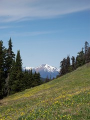
Skwaha Lake 29/05/09
Chris at Skwaha Lake:
“Snow-free meadows? With ridgetop views? At 1800 m? In May?!? You betcha! Andrew, Cara and Giri joined me on an exploration of the Skwaha Lake area. We approached from the north via 2wd drivable logging roads up Laluwissin Creek and past Onion and Turnip Lakes. There are no trails (except very old cattle routes) so we did a fair share of bushwhacking (some of it was pretty exhausting – hopping from log to log without touching the ground for 50 m at a stretch). The meadows were full of Avalanche Lilies and Shootingstar. Lower down, the Balsamroot was starting to bloom and we found many Chocolate Lilies. And a couple of bears. On the last day, we headed north of the access road and hiked up an unnamed ridge topping out at 2000 m with good views across the Fraser to the mountains of the Stein.”
Cornwall Hills 16/05/09
Chris in the Cornwall Hills:
“Allison, Cara and I ventured into the backcountry west of Ashcroft for a weekend of bushwhacking and bears. Though Hat Creek Road is marked as 4wd on the Backroads Map book, it turned out to be one of the best gravel roads I’ve driven on for at least 11.5 km and the last farm house. After this point, it was still pretty good to where we parked another 2 km along at the fork to Cornwall Hills PP (after this point, both roads are 4wd). We hiked up a draw to a set of aspen meadows that took us almost all the way to Bedard Lake (elevation 1400 m and snow-free). The area is well used by cows starting in June but right now it’s left to the bears (saw 2 black ones and heard about one very large cinnamon or grizzly) and elk. On the middle day, Cara and I bushwhacked to some hillside meadows to the north through undulating pine-kill forest (read: lots of deadfall, few lines of sight and pockets of snow). At 1700 m, there was 2+ feet of soft snow in the trees between meadows making travel slow. The meadows gave good views into Hat Creek Valley, to the Clear and Scarped Ranges and beyond. Excellent navigation skills and tools are required for this area.”
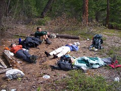
Lower Stein Valley 10/04/09
Chris in the Lower Stein Valley:
“Cara, Michele, Norico, Ribeka and I spent 3 days of mixed weather in the Lower Stein valley. Since it’s one of the only early-season overnight destinations within a reasonable drive of Vancouver, it was pretty busy – almost as busy as the May long weekend is traditionally. Teepee camp was packed and both Earl’s and Cable Car had 8-10 tents. We spend two nights at Cable Car and dayhiked to Ponderosa. The trail was snow- and mud- free and there were no blowdowns to speak of. The river was about 4-8 feet below spring levels and river-side snow and ice made water access tricky in places. Nights were cold but above freezing and the days were warm when the sun came out. There’s a dead deer in the river across from Kline’s Cabin so treat your water. We were back at the cars half an hour before the hard rain started and ate Chinese food in Hope while discussing the merits of curry-flavoured bubble bath.”