Chris N. at Cirque Lake:
“The bushwhack in to Cirque from the Conflict Lake trail is far from straight-forward. Attempt only if you are very comfortable with steep bush and are armed with at least a map, compass and/or GPS, and a good, intuitive feel for where you are. Basically, we hiked the Conflict Lake trail for about 20 min to just past a small pond. From here, we bushwhacked north to find the base of the cliffy, discontinuous ridge running up to Hidden. Climbed the ridge until about 1600 m elevation where we started to sidehill along a set of narrow benches in the forest. Eventually, we found ourselves at a pass that dropped us down to the south-west corner of Cirque. We made our way around the west side of the lake and climbed the meadows to a ridge to the north-east. Here we camped (there’s several flat spots) just above a smaller lake. We climbed Lonely and explored more small lakes to the north (and found much garbage from snowmobilers who frequent the area from the Soo valley in the winter). We returned the way we came in but lost the route once we hit the ridge edge so we headed due south to meet the Conflict Lake trail about 10 min west of where we left it. If you are planning a trip in the area, canoeing to the end of Callaghan Lake and taking the established trail to Cirque would be much easier. The lake edge is steep in most places but there are some good camping spots to the north and 100 m higher than the lake.”
Tag Archives: bushwhack
Waterfalls Plateau, 31 Aug 2013
Chris N. on Waterfalls Plateau:
“The lack of 4wds on Wanderung showed as I couldn’t scare up another driver and the ensuing logistical complications meant that only 2 of us left Vancouver at 7 am on our way to adventure and discovery. The Hurley was pretty awful – really in need of a grading. There was a huge pack of cars at the Semaphore Lakes trailhead as we passed – almost as many as you see at the Keith’s Hut parking area. The first 7 km of the Hope Creek FSR were in pretty good condition with some minor rutting left over from a recent wet spell. The east branch was definitely 4wd with frequent short but sharp waterbars needing good clearance and a 1 km stretch of close alder. We parked at the Beaujolais / Mystery scrambling parking area. The bushwhacking was moderate and short and we would encounter the odd flagging but didn’t find any specific trail except animal routes. Most of the route to Noel Pass was in narrow, heathery meadows. A tarn at the pass yielded almost-frog tadpoles, a newt and a multitude of water boatman bugs. We also encountered signs of winter sled traffic – shredded beer cans. We side-hilled into Noel encountering much krummholz and steep forest. Climbing the first side valley on the west brought us onto the rocky plateau that I had hoped would be more vegetated. But we found good camping spots near a tarn that was still melting out. On the middle day, we rambled west and found even better camping spots as we went and plentiful tarns. We interrupted a ptarmigan party, watched raptors hunt and eavesdropped on pika conversations. At one point, we spotted what may have been a wolverine! Returning to the car on the Monday, we descended due south through meadows and an old burn encountering some old flagging tape on the way back to the road. Along the way, we swashbuckled moptops and discussed the prevalence of walrus-mounted alpine mammals.”
Upper Statlu Lake, 6 Jul 2013
Katya at Upper Statlu Lake:
“Four adventurous Wanderungers, Alazhar, Rob, Alexandra, and I, headed up to the Upper Statlu Lake (also known as Brotherhood Lake) last weekend. As one of us later noted, this trail is truly a “diamond in the rough”: it is overgrown and difficult to follow at times but it rewards you with spectacular views at every turn. We followed the directions to the trailhead and waypoints from this Club Tread entry. Be warned that the directions in 103 Hikes are outdated due to a recent landslide. The drive from Vancouver took just over three hours with the last portion on logging roads. The roads were in surprisingly good shape: they had been recently graded and should be accessible by 2WD vehicles for some time.
The first leg of the trail took us across two creeks and past a massive waterfall to the Lower Lake. The deadfall on the old logging road sections was thick, but the rest of the trail was fairly easy to follow. We came across two small campsites at the east end of the lake that could snugly fit up to two tents. As the trail continued along the north end of the lake it became significantly harder to follow: it crossed several talus fields and dense blueberry thickets. We wished we had brought clippers to clear our way and beat the bush. The views all along the lakeside were spectacular and ripe blueberries kept our spirits high.
At about 2/3 of the way to the far end of the lake we took a sharp right up the Brotherhood Trail. Please note that both the Club Tread entry and 103 Hikes take you to the far end of the Lower Statlu lake, not to the Upper lake. If you are looking for waypoints this resource might be helpful. The trail went steeply uphill, foot bed fairly well worn. We followed the trail until we came across a rocky gulley, where it just stopped. It took good fifteen minutes before we spotted some tape to the left across the gulley. The terrain was steep and unstable; the trail lead vertically uphill. From here on the trail was almost non-existent: just a few flags here and there. The last 200 m before the lake were a challenging bushwhack, but once at the lake, it was all worth it. We had a quick swim and ate our snacks on a sandbar overlooking a dozen waterfalls. We spotted a small site at the western end of the lake with a fire pit couple of logs, and two flat tent spots.
On our way back we reflagged the last section of the trail and added a rope to one of the steep climbs. It took us 13 hours for the round trip at an average fit hiker speed! We hiked the last hour and a half in the dark. Three drivers had to take turns on the drive back – we were that tired. Overall, a greatly rewarding adventure with a fantastic group of people!”
Skwaha Lake 29/05/09
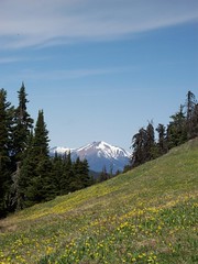
Chris at Skwaha Lake:
“Snow-free meadows? With ridgetop views? At 1800 m? In May?!? You betcha! Andrew, Cara and Giri joined me on an exploration of the Skwaha Lake area. We approached from the north via 2wd drivable logging roads up Laluwissin Creek and past Onion and Turnip Lakes. There are no trails (except very old cattle routes) so we did a fair share of bushwhacking (some of it was pretty exhausting – hopping from log to log without touching the ground for 50 m at a stretch). The meadows were full of Avalanche Lilies and Shootingstar. Lower down, the Balsamroot was starting to bloom and we found many Chocolate Lilies. And a couple of bears. On the last day, we headed north of the access road and hiked up an unnamed ridge topping out at 2000 m with good views across the Fraser to the mountains of the Stein.”