Category Archives: Scramble

Semaphore Lakes 16/10/10

Ben at Semaphore Lakes:
“The time of year was near perfect for a trip to this area. While the lower portion of the trail was very muddy, the ground in the bowl containing the lakes was nicely frozen. There was a light blanket of snow varying from sparse patches in the sunny spots to several inches in the shade of the ridges. It was just enough to add beauty to the alpine scenes without making travel difficult. After establishing camp we made our way up Locomotive Mountain. We followed the gentle southern ridge which cannot be seen from the lakes. The route was mostly snow-covered talus and easy to follow. On the summit, the air was cold and clear, and the views were exceptional. Although the sun set well before we made it back to camp, the half moon was bright on the snow and we had no problems. After a very chilly night we were happy to see the sun crest over the ridge at around 10:00. On this day we went for a nice walk along the ridge to the east, and then meandered our way around the lakes and back to the trail. Thanks to Bill and Mazy for joining me and contributing to this great trip.”

Semaphore Lakes, Oct. 16-17, 2010

Tszil Peak 02/10/10

Irina on Tszil and Taylor Peaks:
“Dan, Pavel, Stephan, Carlos and Evgeny joined me, and Saturday morning we started the hike from the Joffre Lakes parking lot. Once near the upper lake, we came across a sign post and followed the route to Tszil glacier. It’s a fairly well trodden trail when on the grass or in the trees, but some route-finding is required on the boulder field.

Spotting the moraine, we first went to the right of it but ran into abundant deadfall. Oh well, let’s see what the moraine is like from the top. It turned out to be quite wide except for a couple of more narrow, half-a-foot wide sections. Then it’s all boulders up to the Tszil-Taylor col. We crossed a couple of small icy snowfields where I would have liked to have and ice axe or traction aides, especially if we were to descend the same way.

While Tszil looked somewhat intimidating from the col, the scrambling turned out to be a lot of fun with no exposure and excellent sturdy rock. The views were spectacular! The whole Cayoosh range was up on display, and Slalok so close! We didn’t even notice how 40 minutes on the top passed, and if we wanted to get to Taylor, we should hurry! So Pavel, Evgeny and I packed quickly and hastened down. From the col, it was 30 min to the top of Taylor, zig-zagging between short cliffs at a good speed. A few quick pictures, and down we go. Back in the col at 5:10 pm, with two hours of daylight left. Dusk descended on us at the second lake, and we caught up with the rest of our group between the first and the second lakes. Huge thanks to Dan who courteously accepted the role of a guide for the other two in the group and descended straight from Tszil, allowing us to bag a second peak.

See full report with geo-tagged pictures on Livetrails: https://livetrails.com/report/1205/0/Tszil_Mountain-Mount_Taylor_loop

Tszil Mnt. & Mnt. Taylor 2.10.2010 142

Mt Outram 28/08/10

Peter A. on Mt Outram:
“Rob, Rebecca, Grazyna, Adrian, Irena, Jen, Jonathan and I braved snow, cloud cover and freezing winds to successfully ascend Mt. Outram. A fantastic adventure, that started with a fleet hike through a beautiful hemlock and Douglas fir forest. Once clear of the trees, after gaining approximately 1,000 metres, we entered a large, picturesque sub-alpine bowl, that revealed that fresh snow had blanketed the high ground, including the rest of our ascent. The snow was beautiful, but made the ascent up the steep, massive boulder field a little slippery. With a keen focus and much exertion, we gained the first summit in 3h 45m from the trailhead. After a bit of moderate scrambling, made trickier by the fresh snow covering the rocks and scree, we made it to the “true” summit. 1800 metre altitude gain. Despite the heavy cloud cover and cold winds, the cloud ceiling was high and there was plenty of blue sky to allow for magnificent 360 degree views. Very cool to see the North Cascades, Baker, and all the familiar Chilliwack mountains from this perspective. We found enough windbreaks and caught enough sun through momentary breaks through the clouds that we stayed on top about 20 minutes. Two other highlights of the hike: Adrian photographing a beautiful mountain goat in the sub alpine, and during our descent, Adrian photographing two ground squirrels overseeing the fields of blueberries where we had stopped to graze. Trail conditions and markings were excellent throughout, even on the final boulder field (just required a little more patience in spotting the red painted rocks). The descent took us 3 hours, and our knees were happy to see the parking lot. We had been on the trail a total of 8 hours. Great day, great hike, great people, finished off with a great meal at the Blue Moose Café in Hope.”

Yak Peak 15/08/10

Erez on Yak Peak:
“Susanne, Rich, Hiromi, Adriana and I woke up early on Sunday and drove on the Coquihalla to the base of Yak peak. The trailhead was pretty easy to find using the directions and way points posted on Club Tread. It was also very well marked all the way to the peak. There was almost no snow at the top. The snowfield was almost completely gone, and you could easily bypass it – no need for any special equipment. It was a great trip with a great company. Thanks a lot to Rich and Adriana for driving.”

Mt Weart 14/08/10

Ben on Mt Weart:
“I have had a recent urge to do something really challenging before the days begin to grow short and weather too uncertain. This trip to Mt. Weart delivered that challenge in full. The abundance of loose rock and lack of snow made this a demanding route. These difficulties were compounded by the sun toasting us at nearly 30 degrees. The route was composed of four distinct segments. The initial portion skirts right along the toe of the Wedgemount glacier and then climbs up the slope on the left side of a creek that is flowing down from a basin above. The route then crosses this basin along a second glacier and ascends a loose slope on the opposite side. It would have been great to see more snow here, but we made do by picking our way up through snow and scree. This slope tops out at another higher and smaller basin/bench where at last the base of the final ridge is in sight. The third part of the route, that is reportedly marked with cairns, is up through the cliffs to the lowest part of the ridge. If there were cairns in the cliffs, they were not obvious. We all picked slightly different lines up and found the top with no problems. There seemed to be plenty of ways to go that were only moderately exposed, but this section would prove to be a bit tricky on the way down. Upon gaining the ridge, we were rewarded with phenomenal views out across the immense Weart Glacier. From here we walked the ridge to the base of the summit and then scrambled our way up the final slope, which consisted mostly of large, semi-stable rocks. It was hard work in the heat of midday, but reaching the summit was a glorious moment and made it all worth while. We had views of…. pretty much everything. A big thanks to Peter, Beau, and Tim for joining me on this very memorable day!”

Mt Weart, Aug. 14-15, 2010

Williams Peak 13/08/10

Andrew R. on Williams Peak:
“I was joined by Rebecca and Valerie on a gorgeous Friday for a hike up to Williams Peak overlooking the Chilliwack Valley. We got an early start and arrived at the well-marked trailhead at 9:30. The trail climbs steeply up to the top of Williams Ridge and then it is a easy (but long) walk along the treed ridge to a rocky knoll where we got out first clear view of the peak itself. We stopped at the knoll for a bit of lunch and to mull over the best route through the basin towards the peak. Luckily I had gotten advice not to descend into the basin but to continue up to the second knoll where we eventually spotted a cairn that told us we were heading in the right direction. Carefully following cairns and flagging, we traversed the side-slope on the left (north) side of the basin. This saved us having to lose and regain a lot of elevation – a huge help! (This route doesn’t seem to match with the route shown in Matt Gunn’s scrambles book. He seems to drop down into the basin.) Along the way Rebecca’s sharp eye spotted a momma and baby black bear moving quickly up the basin below us. It was her first bear sighting and an exciting spotting. We continued across the boulder field at the base of the peak (loudly, in case the bears were still in the area) and gained a rocky ramp that took us around to the scrambling gully on the south side of the peak. There seem to be a few options here, but all the routes seemed to converge on the main gully, which is STEEP. Some fun scrambling up this section. We reached the summit and enjoyed a good 45 minutes or so with fantastic views in all directions before reluctantly making our way down. We carefully retraced our route to find the flagging and the route around the side of the basin. At this point you are very glad not to have to descend into and climb back out of the basin! After gaining the ridge and having a last look back at the impressive peak we’d just descended from, it was a long dusty march back through the trees to the car. A long and tiring day, but the good company, fun scrambling, and great summit views made it totally worthwhile.”

Brandywine Mountain 08/08/10

Esther on Brandywine Mountain:
“We had a hard time driving to the trailhead. Shortly after turning left off Hwy 99, vehicles should make a sharp left turn on to an unpaved road towards “Brandywine Valley” upon reaching the junction where the paved road continues on the right to Callaghan Valley Ski Area. On the unpaved road, we passed a factory and then a big dusty parking lot before reaching a billboard. After that, the road branches were usually blocked off. We could have followed the main road until the junctions that 103 Hikes and Scrambles of SW BC mention, if the road hadn’t been so bumpy and steep in parts that we thought we had to be lost. One of the vehicles had to park half-way up. Our other vehicle (4WD) relayed the stranded half of the group to the trailhead. 2WD vehicles will need good clearance to make it almost to the trailhead.

We hiked from noon to 8:30pm. The approach to the meadows was steep, muddy, and well-marked. There was no snow in the meadows, but there was way more mud and mosquitoes then the wildflowers that were just starting to bloom. Hello gaiters!

After crossing the meadows and small streams, we hiked up a big snow patch over the scree below the ridge leading to Brandywine Mountain. The route was probably further left of this snow patch. We then followed the ridge to the top of Brandywine Mountain, over a little scree, a nice dirt path, a little snow, and big boulders. Amazing views when clouds moved aside briefly.

We returned along the ridge to the big snow face and slid down it for 30 minutes. Then we hiked back fast because the mosquito army was bombarding us full on.

Out at 8:30 pm, then we relayed people to the stranded car, and finally rolled into the Watershed Cafe for dinner at 9:40 pm. Long day, but what a great group!”

Black Tusk 31/07/10

Dan on Black Tusk:
“Technical scrambles should ideally be attempted by experienced hikers; but not if you witness the woefully underequipped throngs that storm Black Tusk every summer. Thinking I would tread a middle ground, I took a mixture of seasoned scramblers & a few adept hikers who are otherwise new to scrambling to try to safely tackle this SWBC landmark.

Saturday morning found 10 joyful Wanderungers hiking up to the subalpine that are Taylor and Black Tusk Meadows – the flowers are now nearing full bloom and the mosquitoes minimal. We made good time, finding ourselves having lunch at the 1805 m mark looking at Garibaldi Lake and the surrounding high peaks at noon. One hour later and we were at Black Tusk base, awaiting our turns to have a go at the chimney.

Putting a lead, a middle, and a sweep in the climbing procession, all ten of us gave it a try in going up the chimney. After waiting out interminable streams of hikers both up- and down- climbing the chimney – and with me trying on the role of `traffic controller’ in the initial portion – the eight of us who cleared the chimney finally completed the 10-minute scramble to the top 1:15 after starting.

With a blue sky panorama at the top, we marvelled at the surrounding cirques, and at Cinder Cone below and other wondrous geological formations & glaciated peaks all around, all the while tirelessly clicking away at our cameras.

After lending assistance to an injured party (kudos to John K. for his advanced first-aid kit and training) we made our way down, mindful that storm clouds had started to move in. At around Black Tusk Junction, the sky emphatically opened up, with big bolts of lightning and thunder and torrential downpours making us sprint down to treeline.

In this well-matched group of blithe and seasoned hikers, a jovial and funtastic time was had by all and we carried the jolly-making to the Shady Tree Pub after. Out of that came an alluring idea for our next Black Tusk adventure: the Helm Creek Meadows approach. Can’t wait!”

Black Tusk 31.07.2010 120

Lake Lovely Water 17/07/10

Erez at Lake Lovely Water:
“Rob M., Rob D., Jo-Anne, Tia, Ben, Michele and I spent a great weekend in Lake Lovely Water. There are several ways to get across the Squamish River to the trail head. We used Jay Bicknell’s jet boat service and took a 20 minute jet boat ride which was a very nice way to start the hike. Jay also made sure our adrenaline level was sufficiently high for the hike as he made an almost 360 degree turn in place just before reaching the trailhead.

I’ve read a lot about the extreme steepness of the trail and so I was expecting a difficult hike up. I also knew that not too many people hike it, and so I wasn’t sure it would be marked well. In reality, I found the trail to be quite manageable. It is steep in parts, but there are steeper trails. In my opinion, it is similar in difficulty to the trail up to Garibaldi Lake, which is longer, but less steep. It was also marked very well, and had very little deadfall. We took our time, and hiked for about 4 hours to reach the lake.

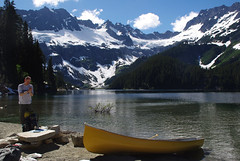
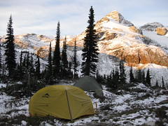
The lake indeed lives up to its name and reputation of being the Lake Louise of the coast mountains. Near the lake there is an ACC hut which we were not going to use. We peeked in and found the hut to be extremely well equipped with a gas stove, table, kitchen with cupboards, and even mattresses for the bunk beds. The people staying in the hut were nice enough to let us use its boats (canoe, and row-boat). Instead of hiking to the sand spit where we intended to camp, we took the boats, loaded our bags, and spent 10 minutes canoeing and rowing to the campsite. The snow level was pretty much at the elevation of the lake so part of the beach was covered in snow, but it was so hot outside, that it was actually quite refreshing. We set up camp, and planned what to do next. Some of us wanted to chill-out in the camp site and go for a (very chill) swim in the lake, and the rest of us decided to explore the western end of the lake by boat. The lake is even more beautiful when seen from the middle. At the western end, there is a large nice waterfall, and two of us scrambled up it to reach the point know as the “Russian Army Camp” – a very nice alpine bowl at about 1400 m surrounded by steep mountain faces and glaciers. We hiked down, and rowed back to camp.

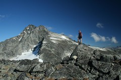
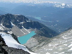
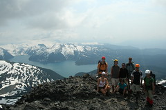
The next day our group split up again. A few of us woke up at 6 am to climb one of the surrounding Greek giants. Our goal was Mt. Pelops. We pretty much followed the scrambling route described in Matt Gunn’s book ascending from its eastern face. The route consists of climbing steep snow slopes and a bit of rock-climbing near the end. We did not use ropes; two of us had ice axes and one of us had crampons. I had neither, and even though it was not a hard route, I would not try it again without both. It took us about 3.5 hours to reach the summit at 2000 m. We had almost perfect weather and the views were glorious. We lingered for about an hour up there, had lunch, and descended. Our descent was much quicker as we slid down on the snow most of the way. It took us only an 1.5 hours to return to the campsite. The rest of our group who did not join us climbing Pelops woke up later and hiked up to Niobe meadows which is at the beginning of our scrambling route. All in all, this was an excellent trip with excellent company.”

16 tant lake three

Tetrahedron 13/09/09

Ahmad on Tetrahedron:
“A big portion of the trail is on an abundant logging road. It is overgrown and it has not been maintained for a long time. I had even doubt that we were following the right way and we took a detour up hoping that we would hit a proper trail. There are many spider webs on the trail. They literally became our trail markers. The trail conditions slightly improves when the steep section starts but this is when we decided to turn back as we were short in time. I estimated we still needed 3 more hours to get to the peak.

Rainy Creek logging road is absolutely rough. I did it before by 2wd car last year but I don’t know how I managed that. Fortunately today, we had a car with high clearance. On the way back, we checked out McNair Creek logging road and it seemed that it was doable by 4×4. I believe this provides a better access point. Another idea is from Mount Steele trailhead.

Our whole trip took 7 hours. I wouldn’t recommend the trail that we did to anyone.”