Category Archives: Overnighter

Illal Creek, 30 Jun 2014

Chris M. at Illal Creek:

“Two of us went into the Illal Creek area for part of the long weekend. Colleen and I left late Sunday night and find a wonderful place to camp just off the Coquihalla Highway, shortly before the Sowaqua Creek exit. A short drive the next day took us to the access turnoff and I was able to drive all the way up the logging road to within 30 seconds of the trailhead. About 10 minutes in to the hike we used a log to cross the creek then we followed a nice trail up through the forest. Within an hour we crossed the scree field and were out in the open. Much of the north-facing slope was still covered in a little snow so we decided to head over to a dry ridge north of Illal Creek. After setting up camp and resting for a bit we followed an old wonderful little trail all the way around and then up Illal Peak. Great close views of Jim Kelly and Coquihalla Mountains. The sunset view of Needle and Yak Peaks from our camp spot was beautiful. On Monday we attacked the surrounding peaks in a mad blur of activity! Well actually it was nothing like that. We lazed around, packed up late-morning. Headed towards Spiral Peak. That started to look steep so we found small flower fields to distract us. Then picked a route across the bowl to join up with the trail down. Back at the car, we used the chilly creek to cool off in, sat in lawn chairs, drank cold beer and ate strawberry-rhubarb pie. I think the drive home was less than 3 hours, including a small stop in Hope.”

Semaphore Lakes, 21 Jun 2014

Chris M. at Semaphore Lakes:

“Six of us in 2 cars went up the newly opened Hurley FSR to Semaphore Lakes for the weekend. The trail in took a little over an hour and had patchy snow sections. We found a nice rocky plateau to set up camp on and then we all headed up towards Locomotive Mountain. Except for the final ridge the entire hike up was still on snow. Ino, Colleen, (another) Chris & myself went the easiest route possible while Cara and Mark tried out a more direct line. There were plenty of fun slides on the way back down. That evening, we enjoyed a variety of beverages while waiting for the stars to appear. The next day, 3 of our group made it to the summit of Face Mountain. Two of us went part way and then returned to camp and relaxed with our 6th member. The hike out was easy.”

Loco Summit

Gabriola Island, 16 May 2014

Brenda C. cycling Gabriola Island:
“My original plan was to do a solo cycle tour of Gabriola Island but decided to invite a few people along. In the end I did a solo cycle tour just as originally planned! I am not sure if it was the forecast of rain on Saturday or that it was only 2 days of a long weekend or that my trip included a Friday but nonetheless, I was happy to do the trip on my own.

I cycled from my home near Broadway and Granville and made it to Horseshoe Bay in 1.5 hours. I left extra early as I was not sure how long it would take me. The sun was rising and there were few cars on the road – it was a lovely ride. The 8:30 am ferry brought me to Nanaimo then then it was an easy cycle to Nanaimo Harbour terminal to catch the ferry to Gabriola. On the ferry I ran into the other Wanderung day cyclists who kindly offered that I could join them for the day. I knew I wanted to take my time checking out the island so I passed on the offer. I hope you guys had a great day! By 11:05 I was on the island and in less than 5 minutes I was at Descanso Regional Campground where I set up my tent and checked out the bay at low tide. Descanso is a very nice campground as far as car camping sites go. It is located in a nice forest area and, though there are no waterfront sites, it is a short walk to the water.

I spent most of Friday cycling along South Road stopping at beaches, checking out the petroglyphs near the United Church and the tide pools at Drumbeg Provincial Park. Gabriola is a nice island for cycling. There are constant rolling hills but overall, not too many steep climbs (South Road leaving the ferry terminal is probably the toughest climb). I had an early dinner at Silva Bay. I’d recommend the restaurant at the marina: a nice, large patio overlooking the marina; good food with vegetarian and gluten free options and cold beer! Oh, and there’s a liquor store next door if you should want to pick up a few bevvies for watching the sunset later. Just a suggestion! That evening as the sun set I checked out the rock formations at Malaspina Gallery and relaxed on a rocky point as sea lions swam by.

Saturday, after breakfast on the waterfront at Descanso Bay, I packed up camp (the friendly camp hosts allowed me to store my stuff at the office while I cycled the island for the day) then went to the Farmer’s Market. There were lots of edible goodies and talented artists. It’s a good spot to pick up a wedding gift! (Just sayin’…) The forecast for Saturday had been rain: wrong! As one of the other patrons of Mad Rona’s Coffee House said ‘there must be a sun pocket over Gabriola Island.’ It was another gorgeous day. I spent a few hours beachcombing at Sandwell Provincial Park. Over the 2 days I went to almost every beach on Gabriola, except for Whalebone Beach. Well, what did I find at Sandwell? Whalebones!!! Or maybe sea lion bones. Ribs, sternum, vertebrae and flipper bones. I called the visitors centre thinking that this was a unique find but when no one came rushing to see my discovery I realized that I am just a city slicker who should have been a marine biologist! That afternoon I caught the 3:15 ferry back to Nanaimo. It gave me plenty of time to walk along the promenade and enjoy an ice cream before heading to Departure Bay for the 5:20 pm ferry. Just as I boarded the ferry it started to rain. Thankfully, it cleared up by the time I reached Horseshoe Bay which allowed me cycle back home again as the sun set behind me. I was quite proud of myself for making this a fully self propelled trip – okay, I had some help from the ferries!

My recommendations:
– Use a BC Ferries Experience card to save on fares and bicycle charges (I saved over $10)
– Camping at Descanso Regional Park: less than 5 minutes to the ferry terminal
– Check out the Farmer’s Market: High quality artisans and yummy treats
– Great beginner to intermediate cycle trip: there are hills but it’s not too challenging.”

Gabriola Sands Provincial Park

Meager Creek, 10 May 2014

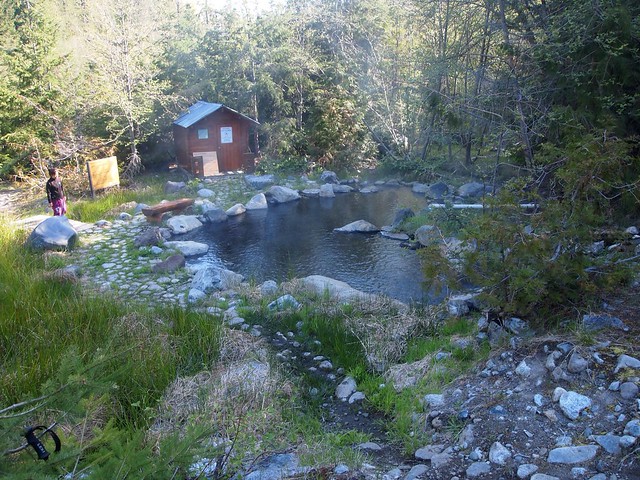
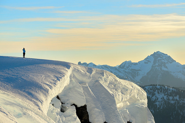
Tu Loan at the Meager Creek hot springs:
“With no news regarding the road conditions, we were uncertain as to how far we could get on the FSR (road after Pemberton Meadows) before hitting snow. A 4wd[1] vehicle was necessary to get up a steep hill at the 23 km marker. Clearance wasn’t too much of an issue, as you just have to avoid the larger size rocks on the road. (Beware that they are building a new road, so make sure you take the steep road going up on the left. If you see big machinery, don’t take that road!). We made it all the way to around 27 km before we were met with some snow (750 m elevation). We parked the cars and the 6 of us headed off to the hot springs with great anticipation!

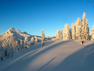
The 3-km trek to the trailhead was uneventful except for the putting on and taking off of snowshoes. We thought that we could do without them, but the snow was soft and we sunk quite deep…deeper for shorter legged people like me! We would encounter a patch of snow, then a long stretch of gravel, before coming upon a long stretch of snow again. We surmised that after a few weeks, one would be able to drive straight to the trailhead. We were at the trailhead in 45 minutes.

According to our fearless leader, the trek to the hot springs was a mere 10 km[2] (!), 6 km of which were to be in the forest and the last 4 on a logging road. What we didn’t realize was how rugged the terrain would be and how the soft snow would hinder our speed. Time was also lost with the taking off and putting on of snowshoes. Our poor snowshoes sure took a beating! With spring conditions, exposed logs and rocks/boulders could not be avoided. The most challenging part of the trek was post holing through the snow in the clear cut sections. We were post holing because we dropped our snowshoes by the small boulder section of the trail, thinking that we no longer needed them. Wrong idea! Poor Bryan found himself chest deep in snow at one point. The best part of the trail was the amazing trail markings by the VOC. Thank you to those who were part of this project. It is very hard to get lost as orange markers were frequently placed and easy to spot.

After 7 hours, we arrived at the hot springs, tired but elated! This was my first visit and a long time waiting[3]! Because of the landslide from 2010, these springs can no longer be accessed by car. The campground had an eerie feeling of abandonment. We were just excited to have the whole place to ourselves! The main pool was well maintained and Fred fiddled with the hot and cold water pipes. Someone thoughtfully left a pond net for us to scoop out the algae. We don’t know when it was last visited, but the pool was mostly clear of algae. Kit noticed that the pool was heart shaped! What better way to end the evening than with an après dinner soak in the hot springs? It was just what our sore and tired bodies needed! Candles were lit for ambiance, and we had a lovely evening of adventure story telling… because that’s what a bunch of Wanderungers talk about on trips!

The trek back was a bit quicker and we were back at the car in 6 hours, with plenty of rest breaks. Again, the clear cut sections proved to be most challenging. BOO for clear cut! The only other heads up is mosquitoes! They made their presence on the trail and at the campsite. I figure they will be in full force after a few weeks. I came home with 10 bites!

Thank you Fred T. for organizing this trip! If not for the snow, the trip would definitely have made the 5 hour timeline. I am hoping to go back in the fall and avoid the mosquitoes. By then, I hope the trail will be well-trodden!

[1] We took with us an Infiniti QX4 (Goldi, her first backcountry adventure) and a Subaru Legacy.
[2] In a straight line.
[3] Personally, 19 years! I know, I know, what was I waiting for?!”

Meager Creek, May 10-11

Iago Peak, 1 Feb 2014

Chris M. on Iago:
“Three of us headed to the Coquihalla area on a cold & cloudy Saturday. We decided on Iago, which shares the same access route as Zupjok. The correct split to take after an hour is less obvious but with a little meandering the col is fairly simple to find. Then it was an hour of uphill to the summit. Sylvia chose a great campsite for us, which was 1 minute from the top, and out of the wind. She and Colleen shared a tent while I attempted an igloo. The blocks were good but with daylight fading and poor construction I realized there would be no roof. Luckily I had brought a siltarp and wrapped it over most of the top. Sylvia shared a neat trick for tying down rope in snow – yogurt lids! The clouds
finally cleared around 5 in the morning and we enjoyed seeing all over the surrounding mountains. It took us 2 hours to get back to the car.”

Phelix Creek, 1 Aug 2013

Steve v. at Phelix Creek:
“Sometimes the weatherman does get it right. A few people (understandably) only wanting to see the ridges around The Brian Waddington hut in decent weather decided to postpone due to poor reports. However at the last minute the reports changed to say only rain in the morning and late after noon of Thursday, and in late morning Friday. Both were bang on. We had a leisurely hike in to the cabin in mild temperatures and slight overcast, and then we did a side trip up a slope near Gandalf mountain and got caught in a thunderstorm 5 minutes from the cabin where we ate dinner warm and inside. In the morning a dry hike out until the last 10 min before the truck.

The Brian Waddington hut sits at the end of Long Lake surrounded by peaks named after notable Lord of the Rings characters. Wildflowers were out and the whole place is very picturesque. Moreover, with the possible exception of Elfin Shelter, this is one of the nicest huts I’ve ever been in, and we had it all to ourselves. The VOC takes very good care of it, at $10 it was a bargain to stay warm and dry. Like any Pemberton hike, this one was worth doing as an overnighter or more if you want to explore those ridges.

The road in is the topic of discussion on many forums. We made it no problem in a new Rav 4 (7.5 inch clearance). Basically anything that calls itself more than a regular car and has AWD would have no problems except the need to pick over a few easy water bars. The foliage on the side of the road is minimal and careful driving can avoid any scratching. Big thanks to Christine for providing her car not knowing that until we got there!”

Phelix Creek, Aug 2013

Golden Ears, 27 Jul 2013

Stacey A. atop Golden Ears:
“Mark, Mike, and Tanya joined me on an overnight hike to Golden Ears. The first part of the hike to Alder Flats was fairly straight forward with some elevation gain. After Alder Flats, you climb up an old logging road that now resembles more of a creek bed, due to the larger rocks, before the steeper hiking starts just after the stairs. The route is well marked with flagging, but we could see where people could get off the trail if not paying attention (per some of the Club Tread posts). The trail climbs consistently up until you hit Panorama Ridge, at times requiring a bit of acrobatics and fancy footwork with our big packs on! The Golden Ears website said the shelter was at the 9 km mark, but it was closer to the 11 km mark. A good part of the trail is in the trees which made for a nice break from the sun, but as you near the ridge, it becomes more exposed. There was no snow the entire way to the shelter/Panorama Ridge. Lots of snow & run off surrounding the shelter and up towards the summit, so lots of opportunity to get water (but you have to cross a bit of a slippery slope to get to the stream). There was no outhouse to be found at the shelter either. LOTS of biting black flies and mosquitoes the whole way up and at camp. That being said, if you are considering doing this as a two day trip, it is absolutely worth the effort to camp at the ridge!! For the hike to the summit, I believe there is a possibility to complete most of it without needing to get on the snow. The snow is fairly soft and quite slippery. Our crew had crampons and was able to hike straight up the snow to a bit of a saddle just before the final ascent (and we saw people doing it with nothing, although they seemed to be slipping a fair bit). There was a steeper scramble right before the summit. The route we took from the shelter took less than an hour to the summit.”

Tullameen Meadows, 15-16 Jun 2013

Chris N. in Tullameen Meadows:
“Colleen and Rob joined me for a trip into the Cascade Recreation Area this past weekend. The trailhead is just past Rhododendron Flats in Manning Park. We elected to take the Whatcom Trail on the way up and encountered our first bit of snow about 100 m below the pass to Punchbowl Lake. We crossed over the Punchbowl outflow stream on a snowbridge and then back again lower down on the mostly submerged log bridge. Snow covered 90% of the trail between the pass and Snass View Camp but the campsite was largely melted out and dry. Trailhead to Snass View at an ever moderating pace took 7 hours. An after-dinner ramble was called due to dark but we were quite close to the hidden lair of the secretive snow frogs. The night was mild and the next day dawned bright and blue. We hiked down to Tulameen horse camp encountering an interesting clear water spring on the way (future site of our spa and resort). The trail was about 80% snow near Snass View but almost all traces of snow were gone from the Tulameen area. Lots of deer and elk sign but no actual sightings (except for the elk-on-walrus episode). We returned by the Dewdney trail following moose prints. Early on, it was obvious that feet were not going to stay dry with the numerous creek crossings. In several places, the trail was under a foot of running water. Snow disappeared around where the creek goes underground. From that point to Dry Lake, there was copious bear scat and trails tramped down through the lush vegetation. Dry Lake wasn’t (in that it was full of super-clear eerily blue water). Light on-and-off sprinkles started at a stop in a cedar grove where we listened to distant thunder rumbling. We got back to the trailhead 4 hours after leaving Snass View. We stopped at the Wildcat Grill between Hope and Chilliwack where we enjoyed food and a spectacular thunderstorm on the patio (and stayed moderately dry in the process). Road closures for paving on the 1 just north of the Port Mann caused a backup starting at the south end of the bridge and probably delayed our arrival in Vancouver by about 45 minutes (apparently, these start around 9 pm every night and would affect any late returns from any hikes to the east).”

Snass Creek is the trail.

Pinecone Lake, 4 May 2013

Chris M. in the Pinecone Lake area:
“With the promise of hot sunny weather, 6 of us drove in from Squamish along the Mamquam FSR. Sadly, the snow was lingering lower down than I had hoped. This meant we had to hike 6 km instead of 3 km to the end of the logging road. We had lunch then carried on. The sun had been killing us so a shady break in the trees was most welcome. Never worried about finding a trail as you just need to stay in the centre of the ridge and head upwards. Just before we reached the top of Peak 5700 the day-trippers reached their turnaround time and headed back down. Well, Danielle and Tom did. Jack couldn’t bear to leave the views that were beginning to reveal themselves and he stayed with us.

Kicked steps up the last steep parts and Jack had made a wise choice – gorgeous views in every direction! We chose our camp spots and relaxed. Then we soaked in a stunning sunset and relaxed some more. Very little wind, warm temps & great company made this a wonderful night. Gary and Tu Loan had brought tents. I just slept on a pad looking up at the stars. (Having no overnight gear Jack had gone back down to sleep in my car – extra blanket & pillow there.) Waking up and seeing the surrounding mountains again was awesome. The walk back down was simple and just under 3 hours to my vehicle. Be warned, the road isn’t that rough but your car will get scratches towards the end.”

Frozen Hiker

Burke Ridge, 9 Feb 2013

Chris M. on Burke Ridge:
“Sean was willing to check this area out with me. The weather was not great on Saturday so instead of enjoying a beautiful sunset we decided to build snow shelters. I started to build an igloo. We had brought a shovel and snow saw. Sean came over and helped. The aid was most appreciated! We then built a more blocky house for him. The morning weather was much nicer but we were both tired and headed back down in the morning. About 3 hours up and 2 hours down. We camped around 1100 m elevation. We took the logging road up and the snow started just after crossing the powerline construction. Only a handful of snowmobiles on Saturday but many more heading up Sunday morning.”

Some assembly required