
Susie D. checking out lakes near Harrison Hot Springs:
“This turned out to be a stellar idea for a day trip! On a hot sunny day it was great to mix swimming with hiking. We first hiked the Whippoorwill Trail at Harrison Lake. It was somewhat offputting to see all the dead salmon floating in the lake after spawning, but we got used to the idea. We then swam at a little sandy bay away from the main Harrison beach. We shared the bay with an guy with a houseboat named the Pimp, but declined his invitation to join him for an afternoon of partying. After gelatos in Harrison we headed on to Hicks Lake in Sasquatch Provincial Park. What a pretty lake! We hiked a couple of km to the far end, where there was a quiet beach that we only had to share with a couple of other groups – space for all. The water was warm, fantastically clear, and we spent quite a long time in the water. After drying off and hanging out on the beach for a bit it was time to head back to town, with a stop at the organic hazelnut store on the way back. We all returned armed with hazelnut butter. The objective of the day was to have a relaxing day away from the city, and we definitely achieved our objective.”
Category Archives: Day hike
Musical Bumps 03/09/11
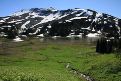
Carollyne on the Musical Bumps:
“Beautiful meadows in bloom, snow fields, a lovely lake, views of glaciers and distant peaks are what we found on this 10 hour day hike. The trail up from Whistler seems a lot easier than the elevation gain would indicate, due to the gradual grade, smooth condition of the trail and the relatively easy creek crossings. Harmony Creek still has no bridge, but the water levels are low enough so it is not difficult to cross. Flute Creek’s bridge is split in the middle and seemed slippery enough that most of us opted to wade across the creek. Louise actually got across with dry boots. The fork in the trail where left goes to Russet Lake and right goes to Musical Bumps appears below the pass, unlike what 103 Hikes indicates. With plenty of time and energy we took the left fork to Russet and were very glad we did. The contrast between the meadows and glaciated rock and snow fields as well as the beautiful lake was fantastic. The hut was very clean and unoccupied, but small enough you could not depend on using it for an overnighter. We had lunch at lakeside following Andrew’s swim. Returning from the lake, we could not find any shortcut trail directly across the pass to the Musical Bumps, so we had to go back to the main fork and hike back up to the bumps. The Oboe “bump”, the first one on the return trip, has the steepest incline, but they all are up and down. There is no water on this return trip until below the last bump, so if you go this way, fill up at the lake. There seem to be some missing signage, so we did not find High Note trail on the return. After the bumps, we took the trail that follows Symphony Lake. This was a bit of a kicker… a fairly steep 3 km back to the Gondola after already hiking at least 24 km. However, it was the only trail we saw that was clearly marked “Gondola” so it seemed like the best choice. We caught the free return gondola down around 8 pm after enjoying the sunset and finished off at Splitz Grill for dinner. The gondola was running unusually late due to the BBQ package at the Roundhouse… normally this would have to be an overnighter or an extremely early start to do in one day.”
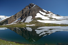
Mt MacFarlane 03/09/11
Jeremy on Mt MacFarlane:
“Four brave souls ventured out towards Chilliwack Saturday September 3rd to climb Mount MacFarlane. The drive took to the trail head took less than two hours, and was completely paved, except for the last 200 metres. Easy with 2WD. The parking lot was pretty full upon arrival, with both day hikers and overnighters parked there. 1770 metres is a lot to ascend, and the trail gets to the point and starts ascending within the first 150 metres or so of the hike. It took us three hours to get to the first lake, with few stops to rest. About one hour in, there is a sharp right turn in the trail – if you are looking down, it is easy to miss! It’s up and up and up, through lush forest, across one boulder field and crossing one creek. It’s definitely a slog. The trail was mostly dry, with a little bit of muddy sections near the lake.
The first lake is beautiful, with Mount MacFarlane staring at you from the south end of the lake, and a waterfall cascading from the upper lake, down the face of the ridge visible from the lake’s edge. There are a few flat spots for camping at the north end of the lake, which is where we camped, but there were better spots at the south end of the lake, a further 10 minutes down the trail, and then a steep descent to the lake edge.
After passing flasks around the fire for a while, we all slept well, tired from hiking, even though we had only hiked 3 hours. Sunday morning, it was just a one hour hike up to the second lake. The trail is steep in sections, but not difficult technically. It was great to hike without all our camping gear! The upper lake was still 70% frozen. It was another 45 minutes up the snow free ridge to the top of the mountain – this portion involved a tiny bit of scrambling but it was mostly hiking. At the top, the views were incredible. We could even see Mt. Rainier to the south. We hiked back down to the first lake quickly, ate lunch, packed up, swam, and headed back to the car. It’s even more of a slog down – it’s relentless down and down and down. Hiking poles definitely helped! On our way down, we passed some hikers coming up who warned us that 4 out of the 6 cars parked overnight had been broken into. Fortunately, we were one of the two cars that remained intact. The drive back was quick with no traffic. Epsom salts baths were in order to soothe sore legs from the descent.”
Panorama Ridge 03/09/11
Stuart on Panorama Ridge:
“It is amazing the difference 9 days makes, most of the alpine flowers in Taylor Meadows have wilted since our last visit. They are however abundant as you head closer towards Panorama Ridge. There is still plenty of snow on the back of the ridge so I would recommend taking hiking poles to assist in the climb. The snow provides a benefit later on as you can bum slide down between the two peaks to avoid the steep descent back down the trail. Just try to stay in the chute created by earlier sliders to avoid the snow speed bumps but be warned it does take a little while before feelings return again. You need to hit the brakes (heels) before passing over the second ridge to control your speed and you probably want to come to a complete stop before deciding to go further as this is the fastest section. The six of us returned via Taylor Meadows 9½ hours later with 1½ hours on top of the ridge. The rest certainly helps recharge the batteries for the return trip. Again, we had perfect weather and amazing views.”
Coliseum Mtn 03/09/11
Hurrian on Coliseum Mountain:
“Six of us headed up Coliseum on Saturday. After the long walk to Norvan Falls we pushed up the very steep part of the trail. Where it levels off, it was muddier than normal, probably because of the snow runoff. Even on the ridge though, there was very little snow, which is good because the very moderate and low exposure scrambles might have been a bit dodgy if they were snow covered. We made it to the summit in about 3 or so hours and had a nice lunch. Thanks to Gareth, Norbert, Iryna, Julie and Danielle for a great hike in great company.”
Cabin Lake 02/09/11
Keith at Cabin Lake (twice):
“I called out 2 trips to Cabin Lake and both went off really well. The hike is short but steep up to the lake and the water was cool and refreshing! One the first jaunt there were 7 peole and the 2nd there were 5. The first trip had about 84.56% on the Cabin Lake Swimability Index (CLSI) and we hit 100% on the second hike where everybody got in the water – the goal was the swim after all. Thanks everybody for their spontaneity on signing up with short notice on the trips!”
Mt Burwell 28/08/11
Peter A. on Mt Burwell:
“Jeremy and I reached the summit of Mt. Burwell via the steep trail from the Lower Seymour Conservation Area. A great day for hiking, playing in snowfields, and taking pictures.
The trail is punishing on the way up: very few breaks from the steep gradient. Fortunately, it’s a pretty trail through the hemlock, Douglas fir, up rock faces and roots, and easy to follow. There is one tricky spot to be aware of that the guide books don’t mention: finding the trail off of the Seymour Valley Lookout (a huge rocky dome/promontory). When you arrive on top of the Lookout (about 1 – 1.5 hours into the hike), there are few cairns/trail markings to guide you onwards. You don’t need them to walk the 3 minutes on the east side of the flat promontory to its northern end for terrific views (Mount Elsay, Mount Seymour, and Seymour Lake to the east and north east, and Coliseum Mountain and Mt. Burwell to the west). However, once you’ve feasted your eyes, rested, and are ready to move onwards – i.e. back down the promontory and down to a col that separates the promontory from Coliseum Mountain – the lack of cairns/trail markings on top can make it difficult to find the trail. There are two choices: the easiest way is to walk back on the west side of the promontory in the direction of the col until you see some cairn and flagging that will lead you to the trail to the col. The second way is to retrace the way you came up, i.e. back down the east side of the promontory and back on the trail for about 5 minutes. At that point, just beyond the edge of a small clearing, on your right (facing downhill), look for flagging on some trees. This is a branch in the trail that you likely didn’t see on your way up. This trail runs west, skirting along the bottom of the promontory and to the col (it meets up with the trail coming down from the west side of the promontory.
The trail along the col and up to the intersection with the Lyn Valley Coliseum trail had spots of deadfall, mud and boulder fields to contend with, but trail markings were always there to be found with a little patience and a keen eye. And when ascending Burwell from the tarn that lies between it and Coliseum, stay to the left even though it looks like your approaching a forested cliff: the trail goes up a cleft in the rocks and is easy.
We ascended Burwell in 4 hours (a good pace), and, including the 19 km round-trip bike ride from the parking lot to the trail head (a lot of uphill pedalling at the end of the day!), we were on the go for 8.5 hours.”
Garibaldi Lake 25/08/11
Stuart at Garibaldi Lake:
“Four of us set off heading up the 6+ km of switchbacks in 1½ hours. After a brief rest at the junction the group headed left and 20 minutes later arrived at Taylor Meadows. The sides of the trails are covered with alpine flowers and definitely worth adding the additional 2 km. Shortly later you have your first glimpse of Black Tusk, don’t forget to check the view behind you once in a while. Continuing along the path you eventually come to the junction for Garibaldi Lake, take a right heading down the switchbacks until you cross the bridge. The trail becomes fun and interesting as at some points you tip toe across rocks breaking the water’s surface to continue around the lake. You should explore the entire trail around the lake as besides the views of the glacier there are some interesting points. Firstly there is a small island accessible from the trail where there are some Indian Paintbrush plants. At the trail end by the ranger’s dock is not the best place to have lunch. The Whisky Jacks create a scene reminiscent of Alfred Hitchcock’s “The Birds”, it was quite bizarre. We headed back the direct route returning 9 hours later.”

Williamson Lake 24/08/11
Steve at Williamson Lake:
“After years of worrying about the “gate” on the road to this trail, I finally was told it would never be shut again so decided to do it. However, a different logging company blocked the access at Chilliwack Lake road… Five of us piled in Steve C’s truck and suffered a long re-route and late start as a result. The trail was steep and not without problems in a) finding the start, and b) crossing a few scary scree slopes. All told it’s a short trail, but it is SO steep that it just did not feel that way and took us over 2 hours up. The payoffs were amazing: wildflowers, the frozen lake itself and surrounding slopes (including a brown bear). Be aware, it IS wildflower season in Chilliwack, so get out there, but if you have a 4X4 AND a fear of exposed heights, head to nearby Mt. Cheam for something less stressful.”
Mt Gardner 21/08/11
Cindy on Mt Gardner
“Six of us made it out to Bowen Island on Sunday. We parked at the trailhead instead of doing the walk from the ferry terminal. If there is a large group, you may want to get the BC Ferries Experience Card. You get quite a large discount on this route.
The distance markers referenced in “103 Hikes” are no longer visible and the side road up to the gate head is now called Hikers Trail Road, not Bowen Pit Rd. The intersections of the different trails do have clear signs, but I would recommend spending some time at the large map near the entrance and deciding what route you want to take before heading up. The trails themselves are typically well marked, but there are a few notable gaps where you might have to do some searching to find the next marker.
We were spoiled with views at the top, with not one but two different platforms on which to sit and enjoy the scenery. A wonderful hike, with wonderful people!”