
Hurrian on Mt Harvey:
“Eight speedy hikers headed up Mount Harvey on Saturday and were treated to breathtaking views of the Lions. There was only just enough snow in one section at the top for me to have a good wipeout by trying to boot ski down a snowy patch. The trail is quite steep to the ridge but is shaded by the trees so it wasn’t terribly hot until we got out onto the ridge. We summited in about 3.5 hours and got to have a spectacular view while eating lunch and snapping shots. Not many other people on the trail except for a pair of pot-smoking middle-aged men. All in all a good hike with good company.”
Category Archives: Day hike
Williams Ridge 15/08/11
Dan R. on Wiliams Ridge:
“Ronald and I were the only ones on the trail until the end of the day. From centre of Vancouver, less than a 2-hour drive both ways. I measured 32 km on my odometer to the trailhead from the turn onto the Chilliwack Lake road. Hike took 3 hours each way, not including breaks. Ridge is about halfway. Trail is less steep as you gain altitude. A few trees down, nothing major. Mild brush growing in, but it got me pretty wet (rained overnight). No snow or mud. No sign of bears. Lots of bugs, except at knoll. Trail peters out at first knoll. Recommend going at least to the 2nd/3rd treeless knoll. If you see the unmarked intersection on the steep part, go left. Unmarked intersection as you gain ridge, go right. Unmarked intersection further along ridge, go left.”
Williams Peak 13/08/11
Eric on Williams Peak:
“Four of us decided to have a go at Williams Peak on Saturday. It is about 1:45 drive from Vancouver and looks very impressive. The parking is 32 km from the turn off to the Chilliwack River Road. The trail is incredibly steep and gruelling. (Think a couple grouse grinds.) Luckily it is in the shade. The well travelled trail kind of peters out in a bowl under the massive pyramid peak. The summit can be gained from a gully hiding behind the right flank of the mountain. We saw a mother grouse with two chicks, also out for a Saturday hike. The entire hike can be made without walking on much snow. Great conversation ensued once the peak was conquered. Milkshakes at white spot followed. What an exhausting and throughoutly satisfying day. Thanks guys.”
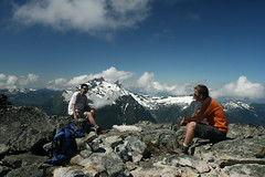
Tricouni Peak 07/08/11
Chris M. on Tricouni Peak
“Six of us went up to Tricouni Peak. The final part of the road was rough on our two 4wds. Trail was certainly muddy to start but we were soon on snow from before the first lake. All us of then went fairly straight up the somewhat steep snow slopes. Erica, Ian & his dog waited near the sub-summit while the four of us – Glenn, Brad, Scott and myself – went up on the top. Bluebird day. The much-sliding down might have been the highlight!”
Hope Mtn 07/08/11
Steve on Hope Mountain:
“Thanks to a great response from 4×4 drivers, 8 of us tackled the trail known mostly for views of the town of Hope (from straight above). Rob and Rob managed the road and got us there safely. The trail was very “Indiana Jones” (overgrown) for much of the way and there were 2 very minor scrambles, and only patches of snow were left. The bushwhacking aspect of this really slowed us down and hike time exceed even my padded estimates. It took us close to 7 hours on trail (some books estimate 5, Club Tread says 6). It was a long day ending at the Wildcat Grill near Harrison, but the weather was great, and surrounding views impressive (though hazy). Word to the wise – never sit ON the cairns at the peak or anywhere else, you never know what the engineering skills are of the person that built it…”
Lynn Peak 06/08/11
Cindy on Lynn Peak:
“Three of us hiked to Lynn Peak, leaving the trailhead at 11am. The parking lot was quite crowded by that time, but the trail itself wasn’t too busy. The trail was dry with only a few slightly muddy patches. If you keep moving the flies aren’t that bad, and the breeze at the viewpoints is enough to keep the worst of the mosquitoes away. As we reached the top, the sun broke through the clouds giving us a great view back towards Vancouver.”
Williams Ridge 06/08/11
Hurrian on Williams Ridge:
“Three of us made it to Williams Ridge. 103 Hikes is a little incorrect about the trailhead. It caused us to look for the trailhead for two hours before the start of the hike. The start is around 30 km down Chilliwack Lake Road rather than the 34.5 it claims. Look for a sign that says “Wms Ridge Trail” that is visible from the road. It gets steep very quickly, ascending 1000 metres in about 3 km or so. After that you hit a ridge that has some stunning views of local mountains. Surprisingly there was very little snow on the trail. Only a bit in the final sections. Definitely recommended hike as long as it’s clear enough for a view. The descent is not as rough on the knees as it could be since much of the top section of the trail is padded with tree mulch.”
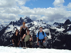
Mt Mulligan 09/07/11
Irina on Mt Mulligan and Anif Peak:
“Following changes to the destination and the participants list, Brad, Melissa and Evgeny joined me for this hike. Brad’s Pathfinder taking us further than expected along the Mamquam FSR shortened the anticipated hike along the logging road by ~4 km each way. After hiking up clear cuts and rarely spaced trees, we found ourselves on the tree-studded Mount Mulligan. Dropped down to the saddle and continued up Anif Peak. The ascent was certainly steeper than I expected, but the snow was perfect for kick-stepping up, and while I was happy to be wearing my crampons, the others managed well without them. A walk along the narrow ridge, and we’re on the summit of Anif Peak. Now that felt like a worthwhile destination, with a close view of the Sky Pilot group and Mount Habrich under blue skies! We settled in on the snow-free south end of the peak and basked under the summer sun for 1.5 hours, enjoying the view and relaxing. It was a breeze getting down to the vehicle through the gully between Mulligan and Anif, leaving us with plenty of time for an enjoyable conversation and an early dinner at the Brew Pub. See full trip report with geotagged pictures on Live Trails.”
Donut Rock 03/07/11
Paul T. on Donut Rock:
“The nine hikers set out in search of the ring. Despite some perils, all nine of us arrived safely at Do-Nut (‘doughnut’? ‘doe nut’? — map says ‘Do-Nut’) Rock before looping back over Eagle Bluffs via the Baden Powell Trail. Paul G suggested an additional loop at the beginning which made the trip more interesting. Instead of starting out on the Trans Canada and crossing to the Baden Powell via the Nelson Canyon/Whyte lake trail (which we took on the way back), we picked up a trail that begins close to the parking lot, right at the north side of the old Highway 1 bridge over Nelson Creek. This trail passes through pretty open hillside with lots of arbutus trees before descending to the Whyte Lake trail very near the BP. There’s a fork about 10 minutes along, you need to go right. The pretty and dramatic Do-Nut Rock trail is not that well marked and if you’re doing it for the first time it is easy to lose your way. Also, it is not well travelled and as a result there are some hazards. The steepest section of the trail is up a dirt hillside where there are loose rocks easily unearthed (as we discovered when the organizer sprung one which Maurice in turn swatted away from the path to his head). Best to keep the group as close together as possible through this stretch to reduce this hazard. The trail from Do-Nut Rock to the Baden Powell is also not well marked and there is still patchy snow though it’s easy to walk on, or, around. Whyte lake is warm enough for a swim.”

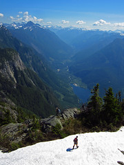
Flora Lake 02/07/11
Dennis on the Flora Lake trail:
“In my callout, I made a remark about “103 Hikes” time estimates being overly generous. Ironically, it took us the prescribed 10 hours to complete this loop. For some of our party, I’m guessing this hike turned out to be a lot tougher than they had anticipated. Our group of four hit the trail at approximately 11 am. The beginning is pretty straightforward as you follow the book’s (103 Hikes) description and the obvious trail markers. The trail is steep for a good 3 – 4 hours as it meanders along numerous switchbacks. But the payoff is worth it. As you climb, the views of the surrounding mountain ranges are immediate and abundant. The view of the Chilliwack lake below in particular is unsurpassed and truly picturesque. As we slowly approached the col, the trail brought us very near a small but pretty waterfall.
At this point, the steepness of the trail begins to relent and the snow makes its first appearance. By my estimate, our first sighting of snow was roughly at 1250 m. Although the grade of the trail eases, do not let this deceive you – our remaining hike in snow proved to be very cumbersome as we post holed many times. Snow levels were still high due to last winter’s heavy snowfall. This combined with the recent warming of the climate made for very soft, wet and unstable snow. In addition, there were no visible trail markers beyond this point. Following the book’s vague description, Dan, our most experience hiker, and I decided to ascend up the hill to where it meets the lowest point of the ridge. At the top, another dilemma – a fork in our “path”. The obvious choice was to head West towards Flora lake and the general direction of the loop. However, as some of you may know, the obvious route is not always the correct one. We decided to choose by process of elimination. I scurried up the “path” (more of a clearing really) heading East. Since this direction led nowhere, we headed West. Remember, there were no visible trail markers after the first appearance of snow. A GPS, compass and strong route finding abilities are recommended in these conditions.
Over the ridge and past the col the only direction is down. As the others cautiously trudged down the steep snow covered hillside, I quickly changed into my rain gear. My descent down the hill as a human crazy carpet began. No matter how old you get, sliding is always fun isn’t it? Naturally, the others wanted to give it a try. So there we were, the four of us Dan, Ulrike, Grace and myself sliding down the hill. At the lake we had snacks and took pictures. The lake was still mostly frozen and surrounded by snow. Beyond the lake, the trail really got tricky. The snow was so high, there was no obvious path or trail to follow. If you go and this is the case, stick to the book’s description. We did and we stayed west of the lake. Boulder fields anyone? Boulder field after boulder field we slowly began our descent down to Lindeman Lake post holing all the way. With no obvious path and trail markers and cairns hard to spot or completely covered in snow, the natural instinct is to head to lower ground and follow the river. Do not do this. Stick to the boulder fields, this is where the path is and what is described in the book. If you get lost at this point, there are five boulder fields immediately after the lake you must cross before the path becomes visible and clear of snow. We found this out the hard way and briefly got “lost” (though we were always headed in the right direction) for 20 minutes or so before returning to the boulder fields.
After this point, the trail is very straightforward and trail markers are abundant. You know what else is abundant? That’s right, more boulder fields. I counted over 12 boulder fields you must traverse through the course of this loop after Flora lake. The trail down the Lindeman side is beautiful and one that I have done many times. Many lakes, waterfalls and small river and creek crossings abound. We made it to the car utterly exhausted. Well, I wasn’t exhausted, just hungry really :). One last tip before I end this lengthy report. This is a long hike. Book time is 10 hours. Absolutely, positively bring a head lamp and always have at least crampons and sunglasses when travelling on snow. Food helps too. Thanks for the snacks Ulrike and Dan! Now all of you reading, go take a hike!”