
Paul T. at Blue Gentian Lake:
“Nice half day trip which involved less than 4 hours of hiking (Brothers Creek trail loop counter clockwise with Crossover Trail as short cut on the way back) and good hour of lounging by the sunny lake with few bugs to aggravate us. One slightly tricky creek crossing involved sidling along a bank and climbing up over a large fallen tree. A couple of group members opted to remove boots and wade through lidocaine. The burgers at the Village Taphouse have declined from their former glory, still a decent choan though.”
Category Archives: Day hike
Baden-Powell Trail 12/06/11
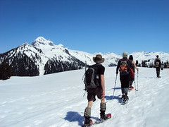
Paul G. on the Baden-Powell trail:
“From the MacDonald Creek trail head at Chippendale Road, four of us kept up a quick steady pace as we climbed to the Hollyburn area where we first encountered snow at the lower cabins. By the time we reached the Boy Scout Camp our pace slowed as the trail had 0.5 to 1.0 m snow coverage. The snowpack is still quite firm, however, with minimal postholing. First Lake is still 75% covered. While the snow was gone around the former Cypress Lodge area where we stopped for lunch, the trail in the woods is still covered until just after the Blue Gentian Lake trail intersection. After that, smooth hiking through the Brothers Creek area and down to the Cleveland Dam. It was a great day for a hike!”
Empetrum Peak 12/06/11
Irina on Empetrum Peak:
“After breakfast at Galileo, our group of four started the hike from the Cheakamus Lake parking lot. A 2 km trip to the turn-off for the bridge across Cheakamus River, and the trail starts climbing up. Consistent snow started at 1080 m, near the end of switchbacks. Most of the snow was firm enough to walk on in boots as some older footprints suggested, but after each of us postholed all the way to the thigh, putting on the snowshoes was a unanimous decision.
It was a long but pleasant hike following the markers where we could find them. In 3 hours, we were at the meadows with first glimpses of mountain ranges around us. Heading west, we chose our ascent route which climbed to the saddle between two of the subsummits. Good snow quality due to lack of sunshine certainly helped, and after another uphill, we were on the ridge. Claudio and Malin chose to stay there, and handing them one of our radios, Evgeny and I continued to the Empetrum peak. It was only another 30 min to the summit, where we were treated to the close-up views of Black Tusk from this rarely visited vantage point.
After rejoining, we tried another route on the southern side of the ridge for the way back. Would have been doable with crampons and ice axes but not all in a group had them, so we retraced our steps and descended an even gentler grade along the ridge. Stayed too far west in the meadows though, and ended up crossing the creeks hiking down and up steep-ish embankments.
A good hike and fun conversations along the way made it an excellent outing. Thanks to Claudio for offering to rent a car and drive. See trip report with geotagged pictures on Live Trails.”

Eagle Bluffs 12/06/11
Paul T. on Eagle Bluffs:
“Seven of us spent a fine day hiking to Eagle Bluffs, picking up the Baden Powell trail from the Black Mountain trailhead just across from the B.C. Ferries work yard in Horseshoe Bay, doing a loop on the way back via Whyte Lake and Nelson Canyon, returning to the starting point by the Seaview Walk in West Van. We completed the hike in just over 5 hours (past groups I’ve been with have done it in closer to 6; fit bunch this time), with leisurely breaks at the Bluffs, and at Whyte Lake on the way back where the water was just mild enough (at least at the surface) for a swim.
The trail to the Bluffs is clear of snow.
Couple of things to note: the junction of the trail to Doughnut Bluffs (lesser used and not well so well known trail) can now cause some confusion because there are a lot of new, bright trail markers at the beginning of this trail and so it might be possible to stray onto this trail without knowing you had. And, the trail approaching the Bluffs is not very well marked.”
The Gargoyles 05/06/11
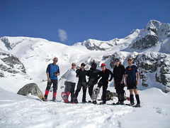
Irina at the Gargoyles:
“Ah, finally, the summer is here! Bright blue skies and snow-clad mountains are calling 🙂 Our group of nine started off from the Elfin Lakes parking lot. Snowshoes, although not strictly necessary, went on from the start. We used the winter route along Paul Ridge, and with stops for snacks and pictures, made it to the Elfin shelter in just over 3 hours. Atwell and Garibaldi were seen from many vantage points along the trail, and we were excited to be getting even closer.
For four in the group, it was a second day out in the baking sun, and they opted for staying at the shelter, while the rest of us were eyeing the route to our destination. The decision was made to go up the safe zone until the end of the tree line, then re-assess the traverse below the steep East face of Columnar Peak from there. Instead of the dreaded sugary snow, we found ourselves walking up firm and well-settled snow. Although moist, it held well. From higher up, the traverse looked much more approachable: the longer-propagating sluffs off Columnar were old, and the fresher ones were short runs-offs at the highest steepest portions of the ridge. We continued on to the Columnar-Gargoyles saddle.
The ridge up Columnar Peak was narrow and heavily corniced, while that of Gargoyles, quite a bit wider. Up we went, reaching the West summit of Gargoyles in about an hour of travel from the shelter. Views of the cornices on the East summit killed any desire to explore that peak. Without regrets, we called it a day and relaxed and enjoyed another hour of the beautiful sunny day on the top, surrounded by mountains, breathing in the warm summer air for the first time this season. A tiny speck of a solo hiker was moving towards Little Diamond Head, and the vastness of the white space around him was intimidating.
Returning to the shelter, we re-joined our group and headed back. I hope all enjoyed a great day in the mountains; I sure did, and a wonderful company was certainly a big part of it. Huge thanks go to our drivers Susanne and Darcy. See full report and geotagged pictures on Live Trails.”
Baden-Powell Trail 22/05/11
Paul G. on the Baden-Powell Trail:
“Seven of us took in this hike along the base of Fromme and Grouse. The undergrowth is greening up nicely and the black flies have arrived. We were teased by the sun for a few minutes, but as we approached East MacKay Creek, the fog thickened, the forest darkened ominously and the skies opened up. Heavy rain and hail, but no frogs. Maybe next year 😉 (2012).”
Mt Gardner 21/05/11
Carollyne on Mt Gardner:
“Even with the very low overcast clouds and showers, this trip was excellent. One goal was not to get lost, unlike every other time I’ve done this hike, and we didn’t, even though the route wasn’t totally as planned. Thanks go to VOC Wiki’s excellent map, Vancouver Trails info and the much improved signage. We intended to take “The Handlogger’s Trail” (Mat Hill trail in 103 hikes) to N. Mt. Gardner trail. Shortly after we began we found a crevasse of a washout. Although the stream flow was low and it would have been easy to cross, this route no longer looked promising so we double backed and took the road until N. Mt. Gardner Trail. From there it was straight forward to the ropes and the helipads, with 360 degree white wall views of cloud. Following a short lunch break, we returned making a loop via the trail near the opposite helipad, the S. Mt. Gardner trail. Total time: 5 h 15 min Cove to Cove. We finished off with dinner at Doc Morgan’s and were back in Vancouver by 6 pm. Other than the washout, the trail was in excellent condition and not muddy. I also picked up a good free map, “Bowen Map & Guide 2011″ on the ferry that seems to include all the trails on Bowen.”
Coliseum Mountain 08/05/11
Ben trying for Coliseum Mountain:
“It is a bit too early in the year to find favourable conditions on this hike. The snowline was at approximately 825 metres and the terrain at this point on the trail is quite rugged. Ugly postholing and slushy snow on the steep slopes made for an unpleasant time. We reached Paton’s Lookout to find ourselves in the middle of a thick cloud. There was only a slim chance that the weather or the snow would improve if we continued, so we decided to turn back and call it a day. I look forward to returning here later in the year.”
Wedgemount Lake 01/05/11
Dan at Wedgemount Lake:
“Finding ourselves with more sunshine than forecasted, we upgraded our destination and headed to Wedgemount Lake for this glorious weekend. The snow was vastly more abundant and better than last winter; there was hardly any no iciness. A congenial group of seven with varying levels of experience, we snowshoed the entire way with only minimal slipperiness. Routefinding did not pose any problems on this trip.
We reprised last spring’s approach and headed up a ridge beneath Mount Cook – descending back down onto Wedgemount Lake – and bypassed the steep and avy-looking summer route. Once at the lake, we witnessed a few cornice-triggered avalanches. Calum videoed one and it is posted on the Wanderung Flickr site.
Three of us then headed across the lake and onto Wedgemount Glacier. We were awestruck by the vast jaggedness of Nature’s beauty, with brilliant vistas and rugged wonders in every direction that took our breaths away! Let me tell you, this is a must-see winter locale if pristine alpine nature is your thing. We did not run into a single soul the entire day! More photos on my Live Trails report.”
Upper Shannon Falls 01/05/11
Steve at Upper Shannon Falls:
“Either I’m out of shape, or someone added a big mound of rock, and few extra clicks to this trail. Probably more the first one… I totally underestimated this as being a short/easy hike despite hiking it before. It is more like a shorter version of the Chief trail with some nice flat bits thrown in. I had a really great group of women sign up (yup, you heard me!), but thankfully the conversation steered clear of the recent Royal Wedding which was my big fear. We took in the falls and the viewpoint, but it took us over 4 hours (moderate pace). This one reminded me of old Wanderung hikes circa 2002 for some reason and I enjoyed it.”
