Category Archives: Snowshoe

Rainbow Lake, 13 Apr 2014

Eugene Y. at Rainbow Lake:
“The winter trail to the Rainbow Lake is a scenic snowshoe route that gradually ascends through an old-growth forest to a sub-alpine country within the Whistler watershed.

Apparently, the route is somewhat underrated by snowshoers, as we haven’t met any other people on the trail besides a lone hiker coming back from Mount Sproatt. Thanks to the watershed regulation, the area is free from snowmobiles, although we did encounter a couple of vehicles passing by the lake.

Practically the whole trail is still covered by deep snow, except for the first 300 m where it gets a bit icy. The trail is well marked and easy to follow, except for a portion between the 2 km and 3 km marks.

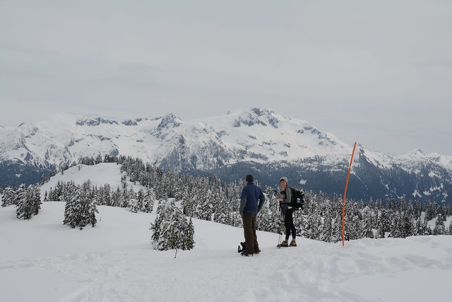
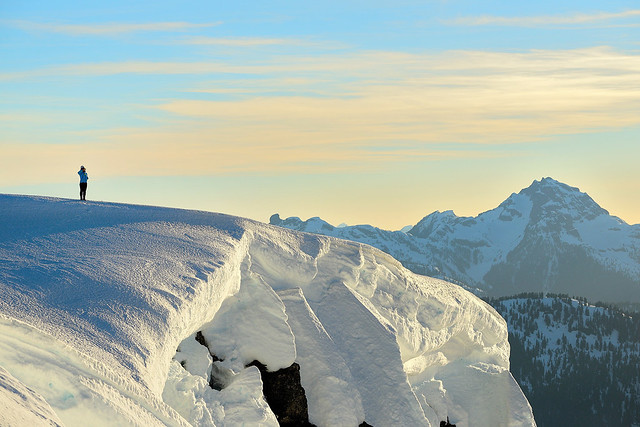
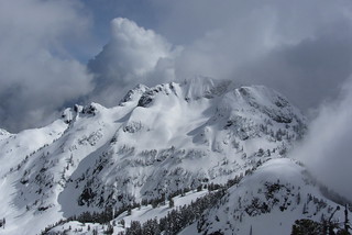
Shortly before the 6 km mark, the trail enters an open area that offered a panoramic view to the surrounding peaks. The suspension bridge after the 6 km mark is removed for the winter, so that we had to cross the creek over a snow bridge about 100 m upstream. Finally, after a short but relatively steep ascent, we arrived to the picturesque Rainbow Lake area, which was still under several metres of snow.

Overall, we found this to be an excellent snowshoe route, on par with the one to the Elfin Lakes but more secluded and with a much easier access to the trailhead.”

Elfin Lakes, 23 Mar 2014

Eugene Y. at Elfin Lakes:
“The upper portion of the road (the last kilometre or so) was a bit icy in the morning, although it seemed to be passable for SUVs with winter tires. However it was just too slippery for our Nissan Sentra and Mazda Protege, so we had to use chains. This proved to be tricky, as one of the chains got loose and wrapped around the driving axle(?) on the way down. The parking lot was almost full when we got there around 11:45 am.

The trail was well packed, so some people just walked in their boots and didn’t use neither snowshoes nor microspikes.

It was partially cloudy – a perfect day for photographers, however the sunscreen and sunglasses were really essential.

We walked at a leisurely pace for about 2.5 hours, while enjoying the views and taking pictures. Ellie found a perfect spot for lunch about facing Mt. Garibaldi and Diamond Head. As people were getting tired and the lakes were still about 3 km away, we decided to cut the hike short. On the way back we had plenty of opportunities to socialize with fellow hikers from other clubs.

It was a really beautiful day to be on the trail. Thanks to everyone in the group for staying together as a team and contributing to the success of the trip. Special thanks to those of you who were helping with chains, it was such dirty work!”

At the high point, with Mamquam Mountain

Singing Pass, 1 Mar 2014

Dennis K. in Singing Pass:
“After a long hiatus from Wanderung, but not hiking, I decided to post a callout for this day hike of Singing Pass & the Musical Bumps. I have to admit it’s quite an ambitious objective for all but those in great fitness. Seven other people signed up for this hike. Unfortunately, two of them dropped out, one due to a legitimate illness, the other due to inclement weather?

The trail was in great condition. All the way to Singing Pass it was generally firm snow, but still had a bit of cushion underfoot which was ideal for snowshoes and skis (unlike the hard-packed concrete conditions you sometimes get on Seymour/Hollyburn). Although the BC Parks websites posts warnings for creek crossings, these have long been covered by snow.

I was lucky to get a really good group that was in great fitness and we were making great time as we approached Singing Pass. Unfortunately, one of our group was not feeling well and had to turn back. Two others joined her. Myself and two others continued to Singing Pass but since visibility was poor it was judged not worthwhile to continue over the Musical Bumps. Instead, we turned back and joined the others in the Village for a well deserved beer and a meal. All in all I was happy I got out. Rain or shine I never regret getting out for a hike. Thanks for all who joined me and made this a fun day.”

Iago Peak, 1 Feb 2014

Chris M. on Iago:
“Three of us headed to the Coquihalla area on a cold & cloudy Saturday. We decided on Iago, which shares the same access route as Zupjok. The correct split to take after an hour is less obvious but with a little meandering the col is fairly simple to find. Then it was an hour of uphill to the summit. Sylvia chose a great campsite for us, which was 1 minute from the top, and out of the wind. She and Colleen shared a tent while I attempted an igloo. The blocks were good but with daylight fading and poor construction I realized there would be no roof. Luckily I had brought a siltarp and wrapped it over most of the top. Sylvia shared a neat trick for tying down rope in snow – yogurt lids! The clouds
finally cleared around 5 in the morning and we enjoyed seeing all over the surrounding mountains. It took us 2 hours to get back to the car.”

Pinecone Lake, 4 May 2013

Chris M. in the Pinecone Lake area:
“With the promise of hot sunny weather, 6 of us drove in from Squamish along the Mamquam FSR. Sadly, the snow was lingering lower down than I had hoped. This meant we had to hike 6 km instead of 3 km to the end of the logging road. We had lunch then carried on. The sun had been killing us so a shady break in the trees was most welcome. Never worried about finding a trail as you just need to stay in the centre of the ridge and head upwards. Just before we reached the top of Peak 5700 the day-trippers reached their turnaround time and headed back down. Well, Danielle and Tom did. Jack couldn’t bear to leave the views that were beginning to reveal themselves and he stayed with us.

Kicked steps up the last steep parts and Jack had made a wise choice – gorgeous views in every direction! We chose our camp spots and relaxed. Then we soaked in a stunning sunset and relaxed some more. Very little wind, warm temps & great company made this a wonderful night. Gary and Tu Loan had brought tents. I just slept on a pad looking up at the stars. (Having no overnight gear Jack had gone back down to sleep in my car – extra blanket & pillow there.) Waking up and seeing the surrounding mountains again was awesome. The walk back down was simple and just under 3 hours to my vehicle. Be warned, the road isn’t that rough but your car will get scratches towards the end.”

Frozen Hiker

Mt Mulligan, 21 Apr 2013

Chris M. on Mt Mulligan:
“Danielle joined me for a last-minute walk up both peaks of Mount Mulligan. We left Vancouver just after noon. The snow continues to melt and the logging road is now driveable to around 700 m elevation. Snowshoes went on right away and we were atop the North Summit in about 2 hours. It was a bit steep between the two peaks but we arrived there one hour later. So many mountains in all directions were visible from the South summit. My snowshoe snapped near the summit but just boots actually made the descent back to the col easier. Along with some fun bum-sliding. On the flatter terrain Danielle was a hero for trading snowshoes with me as I was sinking deeper. Even after lingering on the summit we still made it back to the car without the need for headlamps. Dinner at the Watershed was a nice way to end the day.”

Sigurd Peak, 20 Apr 2013

Pardeep on Sigurd Peak:
“For a tougher trip I was quite surprised that I was able to get five of my buddies to wake up at 5:00am for a hike. Bala ‘The Baritone Baller’ Kumar, Oudi ‘Owly’ Cherfi, Mark ‘MC Pirogi’ Bondyra, Mark ‘Dragonfly’ Jenkins, Ross ‘Ramblin’ Rose’ Polutnik, and myself P. Diddy Montaigne’ made good on our collective word to reach the summit of Sigurd Peak or Station Rose as others may know it as.

The trailhead can easily be reached with 2WD vehicle; for driving directions visit the Club Tread page for Sigurd Peak, https://www.clubtread.com/routes/Route.aspx?Route=1121. The trail initially starts out along an old road bed, but quickly it veers right off into the forest. The trees that I saw during this were awesomely huge and beautiful! If the late great Randy Stoltmann’s name is associated with an area, you can expect to view some majestic cedars.

The trail is for the most part quite steep; think of doing the Grouse Grind for about nine hours; there is no gondola! I love steep slopes, they’re something so cathartic of pushing yourself physically through an old growth forest and seeing views of the Squamish River Valley and Ossa/Pelion Mountains.

At about 1170 m elevation, the route pushes North around a bluff section, before curling back East, and then heading up the main East running ridge system. Three of the group followed that route, while three went South and then East. I was with the group that went South; it was an interesting choice. We quickly had to start veggie belaying, and eventually were cliffed out. I would recommend not going this way, haha.

The East Ridge itself is quite broad and has great views in all directions; that’s if you’re not socked in. Though the clouds pushed in and out sporadically, that which I did see was superb! The final section of the summit ridge was heavily corniced. I would suggest just sticking to the middle and avoid any complications may arise from travelling too far to the edge of the ridge.

For a group of six young opinionated males, we worked well as a collective. I really enjoyed this trip with my friends, and would like to thank them all for coming along! The next trip? Tzsil Mountain near Joffre Lakes, or something in central Cheam Range.”

Hat Mountain, 14 Apr 2013

Pardeep on Hat Mountain:
“Hat Mountain, what a beauty of a summit! Roberto M., Mark J, and I chose the Tunnel Point trail which starts opposite of viewpoint pullout along Highway 99; the viewpoint is North of Lions Bay. The trail was in great condition and offers many views of the ocean and islands. The trail connects up to the FSR that runs North-South. We headed generally North, until the trail starts ramping up to the East towards Hat. We chose the South Ridge approach, but based on my compass bearing, we were more so on the West ridge; the South and West ridge system is pretty broad.

The snow was quite steep in many sections, and it would be helpful to have an ice axe. Just below the summit, there was a short section of technically steep snow, at least in my opinion. The views though… Holy Moly! Windsor, Gotha (Peak 5400), Coburg, Hanover, and the beautiful North Face of Brunswick; any which way, it was fantastic. I would highly recommend this as a destination; it’s an obscure mountain that doesn’t seem to get much attention. I would also like to give a huge thank you to Weedwhacker over at Club Tread. This guy volitionally maintains the Hat Mountain trail. I can say without hesitation, the trail markings and small maps provided are the best I’ve encountered. His efforts make reaching the summit a breeze. Thank you!”

North Face of Brunswick

Burke Ridge, 9 Feb 2013

Chris M. on Burke Ridge:
“Sean was willing to check this area out with me. The weather was not great on Saturday so instead of enjoying a beautiful sunset we decided to build snow shelters. I started to build an igloo. We had brought a shovel and snow saw. Sean came over and helped. The aid was most appreciated! We then built a more blocky house for him. The morning weather was much nicer but we were both tired and headed back down in the morning. About 3 hours up and 2 hours down. We camped around 1100 m elevation. We took the logging road up and the snow started just after crossing the powerline construction. Only a handful of snowmobiles on Saturday but many more heading up Sunday morning.”

Some assembly required