Category Archives: Day hike

Mt Seymour, 28 Feb 2015

Bob H. on Mt Seymour:
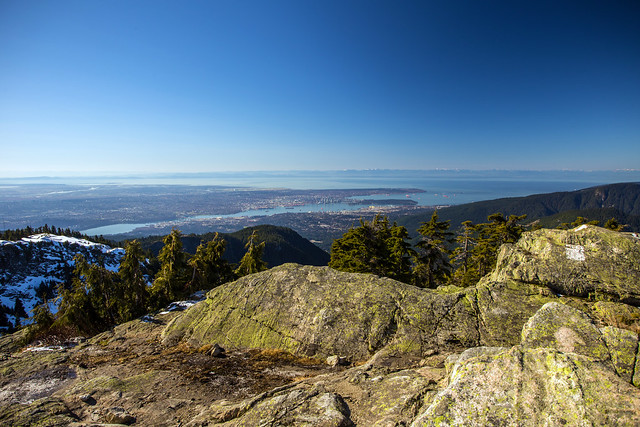
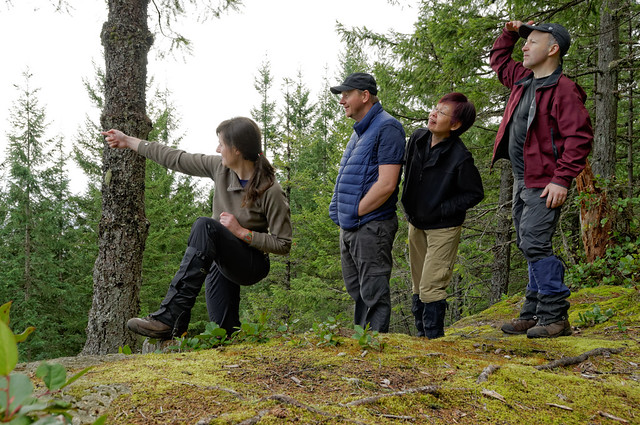
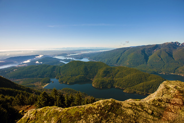
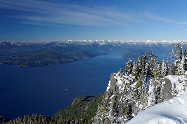
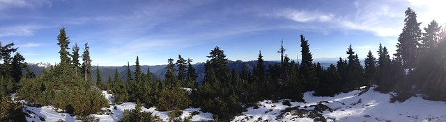
“What a beautiful late winter day for a hike. On arrival to the parking lot (1,020 m), there were only a handful of cars at 9:00 am and not many other hikers were seen on the way up. Stopped to put on micro-spikes at 2 km into the hike at 1,230 m elevation due to increased hard snow and ice. Arrival at the first peak (1,395 m) was made in 1 hour and had a 15 minute break for photos. The snow was about 1 m thick here. Still not too many people seen. There were amazing views of Vancouver, Indian Arm and the Coast Mountains. Onward and upward to Mt. Seymour Peak. It gets technically more difficult here; although, not for seasoned hikers. Due to a few cm of fresh snow, it was apparent that two hikers were ahead. There is some class 3 scrambling here and some cliff walking, but it was all good. Made it to the summit (1,475 m) 30 minutes after leaving the first peak and lo and behold, there were the two other hikers. After having a conversation and taking more photos we all made the descent together starting at 11:00 am. On the descent, the crowds coming up were insane, especially below the first peak. Also, I couldn’t believe the number of people in runners up there! Anyways, we arrived down at 12:40 pm and was greeted with a very warm car! All in all, it was an absolute amazing day for a hike and the views were amazing. Will definitely go back!”

Mt. Seymour summit - 1475 m

Oyster Dome, 22 Feb 2015

Stephen H. on Oyster Dome:
“Welcome to the Oyster Dome. Judging by the scores of people on this trail, it’s Bellingham’s version of the Grouse Grind. The Salish Sea views from the clifftop, however, were more than enough reward. We turned our trip into a very enjoyable loop by returning on the quieter Pacific Northwest Trail. Even a clearcut on the way back couldn’t dampen our enthusiasm. Thanks to Bob, Angela, and Nuria for an awesome day.”

K2, 20 Feb 2015

Andy G. on K2:
“This was definitely not the lofty summit of a Himalayan giant with a panoramic vista, but a tree-covered knoll with a few small jigsaw-puzzle pieces of a view over Gambier, Keats and Bowen Islands towards Vancouver. How small? Maybe half-a-dozen pieces from a 1000-piece puzzle? Yeah – that’s not much of a view. And the route was not an awe-inspiring valley with glaciers tumbling in all directions, but a path through scrubby second-growth forest.

While K2 was never signposted until after Langdale Falls, the trail was mostly very well marked. Follow purple markers and signs to begin with but navigation becomes a little trickier upon reaching the Sprockids mountain bike park. After the purple came the yellow, followed by blue and red markers when we turned off towards our destination. This brought us to Langdale Falls, a lovely little ponytail of water tumbling about 30 feet. Beyond the falls (where there is no bridge to cross the creek), the trail deteriorated and on more than one occasion we had to stop and make sure we were still on the trail. Hint: if you run out of markers on your side of the tree, stop and look back the way you came to check for markers (they’re now orange or red heading to K2). On our return, we opted to take the YMCA trail (blue markers) and were glad we did as it was much shorter (3 hours up, 1.5 down).

But it wasn’t a trip without its highlights. A sunny ferry ride with gorgeous afternoon light on the mountains of Howe Sound (complete with a sundog reflecting in the sea) and a good group go a long way to making a trip enjoyable. Thanks to Steve for suggesting it (I think…) and to Louise and Susan for good company. The day was topped off with the sight of Mars nestled between Venus and a slim crescent moon on the drive home.”

K2, 20 Feb 2015

Lindsay Lake, 15 Feb 2015

Andrew W. at Lindsay Lake:
“Spring has sprung early and trails normally covered by a huge dump of snow are bare and ready for hiking. A small group of two hiked to Lindsay Lake (near Buntzen Lake) for the ~13 km and 1 km of vertical. A tiny bit of snow at higher elevations in the shade but the view of Vancouver was spectacular! No bugs due to the early season conditions was just the icing on the cake for this great local hike!”

The Pulpit Viewpoint

Teapot Hill, 8 Feb 2015

Stephen H. on Teapot Hill:
“The weather forecast had called for lots of rain, but we lucked out with sun and clouds. In short, it was a great day for a hike to the Seven Sisters and Teapot Hill at Cultus Lake. Teapot Hill lived up to its name, so Angela, Ivy, and Robert joined me in trying to spot as many of these ceramics in the nooks and crannies along the trail. Our approach via the Seven Sisters Trail allowed us to enjoy the lush rainforest in some solitude before joining the crowd on the hill.”

Dog Mountain, 13 Jan 2015

Stephen H. at Dog Mountain:
“Ganna, Mary, and Quentin joined me for a quick hike to Dog Mountain on Mount Seymour. We visited Dinkey Peak during the hike in, and lunched at our destination with great city views and hungry ravens and whiskey jacks. Significant sections of the trail carried no snow, but we all wore traction devices under our boots. No use for snowshoes here yet.”

Cypress Lake, 1 Jan 2015

Stephen H. at Cypress Lake:
“2015 got off to a great start with this New Year’s Day hike to Cypress Lake in Coquitlam. Andrea, Lindsey, Mary, and Susan joined me on the snowy and icy backroads leading up Eagle Ridge from Westwood Plateau. There wasn’t enough of the white stuff for snowshoes, but microspikes were essential. While the minor top of Cypress Mountain proved elusive, the lake was easy enough to find. The day’s scenery included bullet casings, empty beer cans, dirt bikes, lots of drops of blood in the snow, two mountain men with homemade hiking staffs, and a startled grouse.”

St Mark’s Summit, 30 Dec 2014

Andy G. at St Mark’s Summit:
“A glorious day out with a relaxed bunch of fellow hikers. Seven of us set off along the trail to St Mark’s, seeking sunshine wherever we could. It was f-f-f-freezing cold near Yew Lake, easily the coldest part of the day, but not too bad a little higher up in the forest where it was cool, light and airy. Bowen Lookout was worth the detour, the Lions were resplendent in their white winter coat, and the whisky jacks were as bold as ever at St Mark’s.

The snow was thin and well compacted along the trail, which was easy to follow. Microspikes or YakTrax were helpful for the descent but not really needed on the way up. Off trail, there was about 20 cm of light powder sitting on an icy crust. This crust bore my weight quite easily, but I had little traction even with YakTrax especially on a slope. Getting to the lower viewpoint was a little tricky as it was hard to make steps in the snow but we all made it and enjoyed lunch in the sun.

A couple of things to note. Day passes are at the old lodge – pick up one *before* you try and cross the ski area. And don’t expect to start on the trail before 9:30 – we (and everyone else) were held up by the fact that the ski resort was still doing work on the runs. I’m guessing that this is mostly due to them having to manage the low snow levels and work to make the skiing any good, and that this restriction might be eased later in the season.”

St Marks Summit, 30 Dec 2014

Hollyburn Peak, 14 Dec 2014

Andrew W. on Hollyburn Peak:
“It was a beautiful day as a party of two headed up Hollyburn Peak for a nice relaxing hike. Snow was scarce with just a dusting of the white stuff at the top, all hard packed down from the rain and freeze-thaw conditions this past week (nowhere near the amount needed for snowshoes.) A little bit of ice in a few places made the trail a little more slippery than usual but on a clear day one could see for miles. A great break from the madness of the malls!”

IMG_0195

Mount Crumpit, 13 Dec 2014

Stephen H. on Mount Crumpit:
“Last month’s trip to Crumpit Woods in Squamish called for a follow-up. Christine, Donna, Jaime, and Sherron joined me for a delightful loop that visited Mount Crumpit, Five Point Hill, and three other hilltops in the woods. With so many mountain bike trails in the area, it’s easy to get off course. Fortunately, a map and GPS kept us from getting lost. We had the place to ourselves (except for the occasional sound of dirt bikes) and enjoyed plenty of views of the Chief. After hiking the Woodpecker trail, we even saw one of those too.”