Category Archives: Day hike

Sigurd Creek, 18 Aug 2013

Eugene at Sigurd Creek:
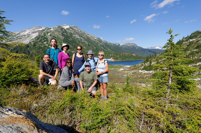
“The gloomy forecast did not deter our group, as 7 of us set to explore the upper portion of the Sigurd Creek trail.

Driving to the trailhead was a breeze, as the Squamish River road has seen lots of improvements in the last couple of months. Most of the potholes are now gone, and, apart from the last few kilometres of gravel, it was all new asphalt.

The trail itself is well maintained and clearly marked. From the trailhead, it took us slightly over an hour to reach Crooked Falls. Even though the waterfalls have lost about half of the volume since May, they were still quite spectacular!

After taking pictures of the waterfalls from different angles, we returned to the trail junction and proceeded along a fairly steep section of the main trail, just past the first viewpoint. Finally, the trail somewhat leveled up, as we reached another jucntion. We took the left fork (toward Ossa and Pelion) and proceeded along a somewhat marshy/wet area sprinkled with blueberries. As the trail approached the creek (shortly before the second viewpoint), we found a good spot for lunch right next to the cascades.

Finally the trail leveled up as it reached the second view point (which we almost missed). Unfortunately, as we were proceeding further along the main trail we bumped into two wasp nests and all of us got stung. The first (larger) nest was about 10-15 min past the second viewpoint where the trail was crossing an open area densely overgrown with bushes and Devil’s Club plants. The second one was about 5 minutes further along the trail. Apparently the area is prone to wasps, as they were mentioned in a couple of older trip reports in 2005 and 2009.

At this point, we abandoned our plans for the moraine camp and turned back. The problem was that we had to pass the nests again, as an alternative would be to do bushwhacking through the stinging Devil’s Club plants and potentially other wasp nests. And, unfortunately, not all of us had long pants. So we put on all the clothes we had and quickly ran through the area as a compact group with more lightly dressed people staying in the front. This strategy proved fairly successful…

In this ordeal, everyone showed an enormous level of cooperation, as people were sharing their anti-histamine supplies and helping each other to inspect/remove the stings. Thank you Jaime, Katarina, Milie, Alice, Tu Loan, and Ellie, for keeping a cool head, you are awesome!

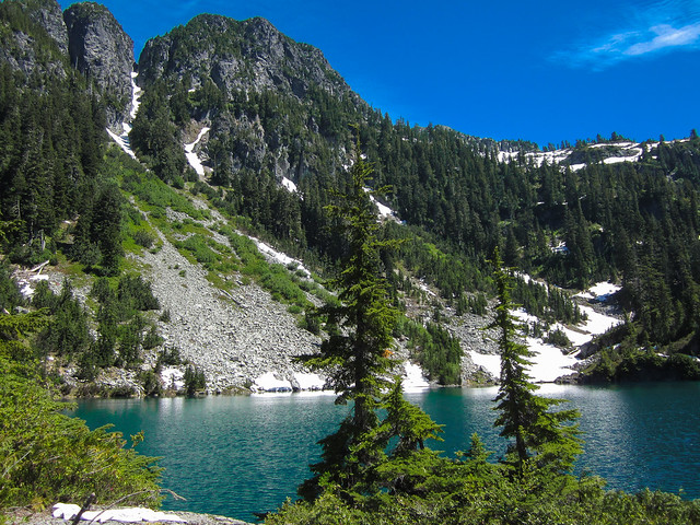
The way down was somewhat slower than going up as many portions of the trail were fairly muddy and slippery. As the weather improved, we caught a decent view from the second lookouts. However the Pelion glacier has substantially receded since May and was barely visible.

I’d like this report to serve as a reminder to all the “minimalist” hikers about the importance of being prepared for wilderness. One can encounter wasps even on the most-travelled routes; perhaps, some of you remember a nest on the Lynn Peak trail (!) a few years ago. It’s always a good idea to carry a long-sleeve jacket and long pants with you even on the hottest day; you never know when they come handy…”

Bug Lake, 14 Aug 2013

Steve v revisiting Bug Lake:
“Oddly, the night BEFORE hiking Bug Lake a second time, I was bitten by mosquitos at home and still have huge bites on me. On the trail, the bugs weren’t bad this time, but I was stung by a bee twice!

This hike was a grudge match, two of us had gone up before and not made it to the top. Eric and I went prepared this time with Frank (a hearty German visitor that had cycled much of the Elaho and Squamish backroads).

This time, instead of walking an extra 4 km on each end due to a slide blocking the road (the tree, however, was cleared) we took bikes and cut that time way down as we rang bells and yelled to scare off any bears we might overtake.

The hike itself was harder this time (for me), and I don’t know why. I found myself out of breath early but I guess it is the second highest gradient listed in 103 Hikes so maybe I shouldn’t be surprised. Unfortunately there was high cloud and later rain, so like the first time, it was a bit of a dark hike and slippery on the way down.

So, is a lake with such an un-appealing name worth doing? I’d say no, not if you just go to the lake anyway. Way too much drama to get there, and minimal payoff save for a few wide views and a mediocre lake. However, maybe what we did would be comparable to entering the shipping entrance of the Taj Mahal. Apparently the famous mountaineer John Clarke considered this area his favourite when accessed from the other side. I get the feeling that like many 103 Hikes, we just got to the door but the payoff was another 5 km away.”

Alder Flats, 27 Jul 2013

Kamen at Alder Flats:
“Four of us set out on a slightly overcast day to explore the approach to Golden Ears. The sun was out and shining when we hit the trail. Light conversation followed as we made good time hiking this fairly well-maintained and not-busy-at-all trail. Some of the bridges and boardwalks were in various states of disrepair which were easily circumvented due to the dry weather lately. We hiked 20 mins past Alder Flats until we got a viewpoint with a fantastic view of the Ears and surrounding mountains. We enjoyed the sun and views for awhile before heading back to the car and back to the big city.”

Rainbow Lake, 20 Jul 2013

Andy G. at Rainbow Lake:
“Perfect conditions for our group of 8 to hike up to Rainbow Lake. The trail is dry and in good condition, though the boardwalks require some care as there are many loose or missing planks. Bugs were much less of a nuisance than I expected, except at Hanging Lake where the mosquitoes were annoying enough for me to spray on some Deet. Woodland flowers are just past peak, but the peak for the marsh and meadow flowers is still a couple of weeks away. We extended this hike to Hanging Lake, which I didn’t really think about at the time, but later I realized it added an extra 4 km and 150 m elevation gain! With the warm temperatures and extra distance, two litres of water was not enough for me and I was glad of the still partly-frozen Nalgene back at the car.

Most of us cooled our feet (and more) in Hanging Lake where the water was pretty chilly (swimming is not permitted in Rainbow Lake). It took us 9 hours in total, a bit more than I expected but a good portion of that extra time was lounging around and cooling off at the lake. A great day out that started with a bear running across the road in front of us just past Squamish, ended with the ever-excellent burger and fries at Splitz Grill.”

Rainbow Lake, 20 Jul 2013

Brunswick Lake, 14 Jul 2013

Steve v. at Brunswick Lake:
“It turns out that the trail beyond Deeks Lake only gets better. None of us actually had high hopes but were game to attempt to bag this one (me especially since I’d failed to summit my last two hikes). We were very pleasantly surprised. After Deeks Lake, the trail levels off and gets almost alpine and took us to two very scenic lakes with views of Hanover, Hat and Brunswick mountains (we waved at Rex doing Brunswick, but he did not see us according to his Facebook post).

My great hiking companions Sophie and Jacqui were super well matched for my pace and gear and we did what was expected to be a 10 hour+ hike in 9.5 hours, with time for a meal at Park Royal.

I want to thank all the people that gave us tips about the recent conditions (people from Club Tread, Meetup, NSH, and Wanderung). There are three river crossings and a sketchy snow slope but as it turns out, we timed it just right. Since last week, the bugs seem to have subsided and the water levels dropped enough for us to carefully cross logs and rocks. As for the road, the gate was open and though a 4×4 would have saved us hours, we actually could have knocked off maybe 45 min with a regular car were we willing to risk the gate being locked (as the sign warned might happen).

The snow slope obstacle that we feared had melted since last week and was doable by going along the shore instead of risking a slide. And do it when no clueless dog owners are around: Jacqui very nearly was knocked off to serious injury by a dog, and different dog later got under my feet on a steep downhill where I was told “just step on him” by the owner. Ya that would have been stable… (pet peeve of mine). Source of aggravation #3 were the people that had a breakfast fire as we arrived at Deeks Lake on the way up. We could smell it. Five hours later it was still warm and being billowed by the wind and could easily have ignited the surrounding dry foliage. However, even these minor annoyances combined were not enough to curb my mood on this great trip.

Lastly, should you choose to check out this trail and are really fit, you may want to consider doing a cross over (key exchange) or one-way hike through Hat Pass to Brunswick, it felt silly not to push forward, but then again this would have been a great place to camp.”

HSCT North, July 2013

Cerise Creek, 13 Jul 2013

Nicky C. at Cerise Creek:
“With Wanderungers always having their backpacks packed in case of a last minute hiking opportunity it didn’t take long for us to find two others to try the Cerise Creek hike in Joffre Provincial Park! It was glorious weather – sunny and not too hot – on July 13th and after 3 hours driving we – Nicky, Gabi, Michael & Sravan – found the trailhead no problems, unlike others before us it seems. The trail was slightly easier than Joffre (fewer roots and smaller boulder field), but without the glacial blue lakes… We weren’t disappointed though – after 2-1/2 hours hiking (completely snow free) we had passed Keith’s Hut and ventured up on top of the ridge overlooking the glacier. Great lunch spot, although the mosquitoes got to us in the end! The descent took us about 2 hours. Since it was Sravan’s first time in the area we stopped in for a peek at the first Joffre lake on the way back, which only gave us a taste for more hikes like it! I would say Joffre Lakes offers more spectacular views, but the fact that we only met a handful of other hikers/climbers on the Cerise Creek trail made it a very attractive alternative.”

Enjoying lunch on the ridge

Upper Statlu Lake, 6 Jul 2013

Katya at Upper Statlu Lake:
“Four adventurous Wanderungers, Alazhar, Rob, Alexandra, and I, headed up to the Upper Statlu Lake (also known as Brotherhood Lake) last weekend. As one of us later noted, this trail is truly a “diamond in the rough”: it is overgrown and difficult to follow at times but it rewards you with spectacular views at every turn. We followed the directions to the trailhead and waypoints from this Club Tread entry. Be warned that the directions in 103 Hikes are outdated due to a recent landslide. The drive from Vancouver took just over three hours with the last portion on logging roads. The roads were in surprisingly good shape: they had been recently graded and should be accessible by 2WD vehicles for some time.

The first leg of the trail took us across two creeks and past a massive waterfall to the Lower Lake. The deadfall on the old logging road sections was thick, but the rest of the trail was fairly easy to follow. We came across two small campsites at the east end of the lake that could snugly fit up to two tents. As the trail continued along the north end of the lake it became significantly harder to follow: it crossed several talus fields and dense blueberry thickets. We wished we had brought clippers to clear our way and beat the bush. The views all along the lakeside were spectacular and ripe blueberries kept our spirits high.

At about 2/3 of the way to the far end of the lake we took a sharp right up the Brotherhood Trail. Please note that both the Club Tread entry and 103 Hikes take you to the far end of the Lower Statlu lake, not to the Upper lake. If you are looking for waypoints this resource might be helpful. The trail went steeply uphill, foot bed fairly well worn. We followed the trail until we came across a rocky gulley, where it just stopped. It took good fifteen minutes before we spotted some tape to the left across the gulley. The terrain was steep and unstable; the trail lead vertically uphill. From here on the trail was almost non-existent: just a few flags here and there. The last 200 m before the lake were a challenging bushwhack, but once at the lake, it was all worth it. We had a quick swim and ate our snacks on a sandbar overlooking a dozen waterfalls. We spotted a small site at the western end of the lake with a fire pit couple of logs, and two flat tent spots.

On our way back we reflagged the last section of the trail and added a rope to one of the steep climbs. It took us 13 hours for the round trip at an average fit hiker speed! We hiked the last hour and a half in the dark. Three drivers had to take turns on the drive back – we were that tired. Overall, a greatly rewarding adventure with a fantastic group of people!”

Bug Lake, 27 Jun 2013

Steve v at Bug Lake:
“This trip was doomed from the start. Pouring rain, and no intel regarding how far we’d get in a 2WD. Despite those warning signs Eric and Kim joined me for a trek into the unknown, to a place with a foreboding name.

The drive most of the way was wet, and muddy but mostly without incident save for a few logging trucks. However, about 4km from the trailhead we hit a rock obstacle and worked our way over, only to hit trees making further driving impossible. We got out and hoofed it.

The trailhead was almost impossible to find, but once we did and got past the first 200 m, it became a decent trail, though steep and muddy… and buggy. We climbed and climbed through what looked like moss and old growth and for some reason Kim got most of the bugs. We never did reach the lake due to the extra 4 km each way and impact to our turn around time, we made it about 60% of the way up the actual trail. I’ve rarely been so soaked through my boots. We finished off the adventure by helping a crashed truck driver fix a flat and then went for BBQ in Squamish.

The unfortunate kicker is that this is one of my goal hikes to complete the 103 Hikes book… so I have to go back. when I do I’ll probably aim for better weather and bring a mountain bike.”

Bug Lake, June 2013

Bike ‘n Grind, 25 Jun 2013

Tu Loan cycling to the Grouse Grind:
What does it take to entice a Bowen Islander to sign up for her first Wanderung activity? A Bike and Grind! Sarah G. showed up with her mountain bike to impress TLT, who was ecstatic that someone actually would want to join her on this callout! Sarah spun her way up to Grouse with ease as she channeled her former ironman and adventure racing days. TLT was in awe!

After about half an hour, they reached the parking lot. Transition from biker to hiker took about 7 minutes. The weather was cooperating and one could see patches of blue sky. This of course was all planned out by TLT. With her MapMyRide app, Sarah was eager to see how she would fare after a 7 year absence from the Grind. This is typical elite athlete attitude. TLT was just happy to have someone to chat with while doing the Grind.

The trail was not very crowded; although you had your usual Grinder with their Lululemon gear powering their way up and the casual tourist with their jeans and checkered shirts. The lighting was nice enough for a couple of pictures. Chatter about food and triathlons were animatedly shared, mostly with TLT asking all the questions. She was kindly told to go ahead to give Sarah some peace and concentration. By the three-quarter mark, the steepest section of the Grind, no chatter was heard as the two were eager to focus all their attention to the finish.

Reaching the top after under an hour AND a bike ride up, the two were elated with their efforts! They meandered their way to the grizzly enclosure to say “hi”. By then, the clouds broke and the beer and nachos (best post-workout combo EVER!) were enjoyed with a great view of the city.

The trip ended with a drop-off to Horseshoe Bay where Sarah was able to catch the 8:50 ferry. Thank you Sarah for making the Bike and Grind so much fun!”

Bike and Grind - June 25, 2013

Gambier Lake, 14 Jun 2013

Steve v. at Gambier Lake:
“Gambier Lake is more like a full day trip including 2 ferries, waiting, and a hike. The trail itself is mostly road and seems longer than the stats might suggest. The lake is nondescript, probably not worth the effort compared to other common lower mainland lake hikes. If you do have a burning desire to see Gambier, I suggest Mt. Killam or if you want to see the lake specifically, go with interesting people that you can chat with to fill the monotony as I did.

I went with Tamara and Emeric (who are keen to join up for a Summer of mid-week trips!), and Kristy and Duncan visiting from Australia. Unfortunately Sherron missed the ferry, and most of the day was grey and drizzly (though the sun did poke out at the end). A few take-aways from our trip should you want to do a Gambier trip:

  • Don’t miss the ferry!
  • The ferry to Langdale you only pay for once, but the small boat to Gambier from Langdale you pay for each way ($7 x2).
  • The General Store on the island seems closed (it used to be a big draw).
  • At Langdale, the food booth higher up the parking lot is WAY better.
  • The time estimates in most books for Gambier Lake are not generous, make sure you can get to your ferry by checking your speed often.
  • Big thanks are owed to the Gambier Island Conservancy for their hard work. They are a very good resource to use if hiking there: https://www.gambierc.ca/index.html”

Gambier Lake, June 2013