Category Archives: Day hike

Cheakamus Lake, 26 May 2013

Andy at Cheakamus Lake:
“I’d forgotten just how nice this trail can be. If you’re thinking of a good little leg-stretcher, Cheakamus Lake should be on your list for sure, especially at this time of year with the forest flowers at the start of their bloom. Our full group of eight chatted its way up to the Singing Creek campground and back, hardly noticing the distance and time. No snow and only one fallen tree to go under/over/around. The road is in decent shape and 2wd can make it to the trailhead easily – just take it slow as there are many potholes. The few drops of rain that fell went unnoticed, and the sun came out again on our return. A hungry pika kept us entertained for a few minutes, munching its way through some of the horsetails. A great group – thanks all for coming out and making this hike such a good one! The only thing that could have improved this hike would have been a bear sighting… Oh wait – we got that on the drive home!”

Cheakamus Lake, 26 May 2013

Baden-Powell Trail, 24 May 2013

Steve on Baden Powell (east):
“A slim response to my Friday callout dropped from 3 to just 2 of us, but Merv was on board with doing a reduced sized hike just the same. I’ve done the one-way version of this many times in both directions, but by leaving a car in Deep Cove and driving to Hyannis Drive we minimized the driving and maximized the hiking for this half distance trip, plus dropping Merv at his car was on my way back to the bridge with hardly a detour.

The weather was with us, a blue sky day, not too hot. We discussed the many trips each of us had done and allow me to say I was impressed by some of the killer ascents my partner for the day had tackled in previous seasons.

As we arrived in Grey Rock it was apparent the walk out to the cove was going to be far less peaceful than the first part of our trip…

We were done before noon and decided to get a Honey’s donut another time.”

Baden Powell, May 2013

Tunnel Bluffs, 19 May 2013

Stephen H. at Tunnel Bluffs:
“Chris, Colleen, Ida, Ivy, Leane, Sebastien, Semiral, and Teresa joined me for a great hike up the well-marked Tunnel Point Trail near Lions Bay. The most dangerous part of this hike: walking across the Sea to Sky Highway to and from the trailhead. Lots of viewpoints provided plenty of opportunities for breaks, and the destination, Tunnel Bluffs Lookout, proved to be a spectacular perch overlooking Howe Sound.”

Columbia River Gorge, 18 May 2013

Chris M. in the Columbia River Gorge:
“One late cancellation and one no-passport problem left us with only 3 people in the car. Which made relaxing in the back seat a prized position! It took Anna, Tu Loan and myself about 7 hours to get down there.

Saturday afternoon we did a 5 mile (8 km) hike that took us past 5 good waterfalls – Wahkeena, Fairy, Ecola, Wiesendanger & Multnomah. The weather was overcast with a little rain – perfect lighting for waterfall photography. We stayed both nights in a reasonable motel at Cascade Locks.

Sunday weather was brighter. So it was a sight-seeing day. We started off trying to walk through Oneonta Gorge but were stymied by one deeper pool just before the waterfall. Six miles of hiking (9.6 km) took us past Horsetail, Ponytail, Middle Oneonta, Elowah & Wahclella Falls. We enjoyed the latter two the most. We had enough time for a visit to Carson, where we had a very relaxing hot springs mineral bath and wrap. Followed by a nice Mexican dinner.

Early Monday morning we hiked 4 miles up Eagle Creek to Punch Bowl & Lower Bunch Bowl Falls. Then we crossed the unimpressive ‘Bridge of the Gods’ over to Washington so we could check out Panther Creek Falls. They were my favourite of my trip. Then it was back on the road and home to Vancouver. We all took turns driving. The conversation and good times never stopped. Border lineups were poor but it does pay to use the Duty Free option.”

Wahclella Falls

Mt Mulligan, 21 Apr 2013

Chris M. on Mt Mulligan:
“Danielle joined me for a last-minute walk up both peaks of Mount Mulligan. We left Vancouver just after noon. The snow continues to melt and the logging road is now driveable to around 700 m elevation. Snowshoes went on right away and we were atop the North Summit in about 2 hours. It was a bit steep between the two peaks but we arrived there one hour later. So many mountains in all directions were visible from the South summit. My snowshoe snapped near the summit but just boots actually made the descent back to the col easier. Along with some fun bum-sliding. On the flatter terrain Danielle was a hero for trading snowshoes with me as I was sinking deeper. Even after lingering on the summit we still made it back to the car without the need for headlamps. Dinner at the Watershed was a nice way to end the day.”

Sigurd Peak, 20 Apr 2013

Pardeep on Sigurd Peak:
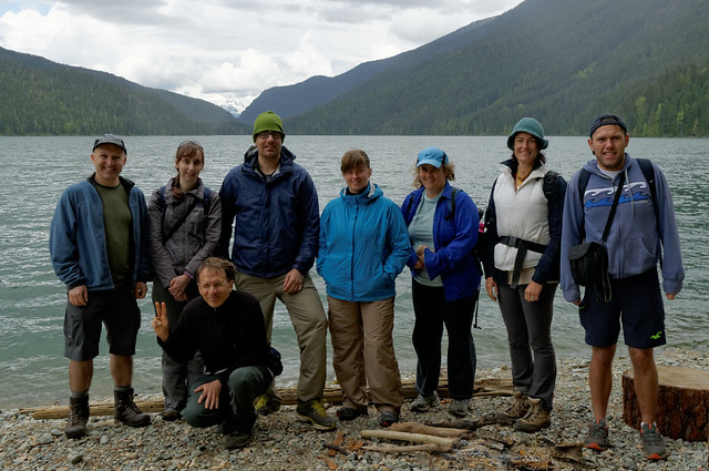
“For a tougher trip I was quite surprised that I was able to get five of my buddies to wake up at 5:00am for a hike. Bala ‘The Baritone Baller’ Kumar, Oudi ‘Owly’ Cherfi, Mark ‘MC Pirogi’ Bondyra, Mark ‘Dragonfly’ Jenkins, Ross ‘Ramblin’ Rose’ Polutnik, and myself P. Diddy Montaigne’ made good on our collective word to reach the summit of Sigurd Peak or Station Rose as others may know it as.

The trailhead can easily be reached with 2WD vehicle; for driving directions visit the Club Tread page for Sigurd Peak, https://www.clubtread.com/routes/Route.aspx?Route=1121. The trail initially starts out along an old road bed, but quickly it veers right off into the forest. The trees that I saw during this were awesomely huge and beautiful! If the late great Randy Stoltmann’s name is associated with an area, you can expect to view some majestic cedars.

The trail is for the most part quite steep; think of doing the Grouse Grind for about nine hours; there is no gondola! I love steep slopes, they’re something so cathartic of pushing yourself physically through an old growth forest and seeing views of the Squamish River Valley and Ossa/Pelion Mountains.

At about 1170 m elevation, the route pushes North around a bluff section, before curling back East, and then heading up the main East running ridge system. Three of the group followed that route, while three went South and then East. I was with the group that went South; it was an interesting choice. We quickly had to start veggie belaying, and eventually were cliffed out. I would recommend not going this way, haha.

The East Ridge itself is quite broad and has great views in all directions; that’s if you’re not socked in. Though the clouds pushed in and out sporadically, that which I did see was superb! The final section of the summit ridge was heavily corniced. I would suggest just sticking to the middle and avoid any complications may arise from travelling too far to the edge of the ridge.

For a group of six young opinionated males, we worked well as a collective. I really enjoyed this trip with my friends, and would like to thank them all for coming along! The next trip? Tzsil Mountain near Joffre Lakes, or something in central Cheam Range.”

Hat Mountain, 14 Apr 2013

Pardeep on Hat Mountain:
“Hat Mountain, what a beauty of a summit! Roberto M., Mark J, and I chose the Tunnel Point trail which starts opposite of viewpoint pullout along Highway 99; the viewpoint is North of Lions Bay. The trail was in great condition and offers many views of the ocean and islands. The trail connects up to the FSR that runs North-South. We headed generally North, until the trail starts ramping up to the East towards Hat. We chose the South Ridge approach, but based on my compass bearing, we were more so on the West ridge; the South and West ridge system is pretty broad.

The snow was quite steep in many sections, and it would be helpful to have an ice axe. Just below the summit, there was a short section of technically steep snow, at least in my opinion. The views though… Holy Moly! Windsor, Gotha (Peak 5400), Coburg, Hanover, and the beautiful North Face of Brunswick; any which way, it was fantastic. I would highly recommend this as a destination; it’s an obscure mountain that doesn’t seem to get much attention. I would also like to give a huge thank you to Weedwhacker over at Club Tread. This guy volitionally maintains the Hat Mountain trail. I can say without hesitation, the trail markings and small maps provided are the best I’ve encountered. His efforts make reaching the summit a breeze. Thank you!”

North Face of Brunswick

Upper Shannon Falls, 29 Mar 2013

Stephen H. at Upper Shannon Falls:
“Ivy, John, and Rasham joined me for a pleasant hike of the Upper Shannon Falls Trail on Good Friday. We started early to beat the crowds, which we ran into on the way down the Chief trail. There was no snow on the route. We enjoyed a long lunch and great views from the final bluff.”

Killarney Lake, 3 Mar 2013

Paula L. circumnavigating Killarney Lake:
“After a week of rain it was great to escape the snowshoeing crowds on the local mountains and opt for a low level hike. Picturesque views, a little muddy but overall a well drained trail that was not over populated and allowed us to enjoy the bird calls and fresh forest fragrance of cedar, cypress, hemlock and ferns. Great interaction along the trail with our group of 4 hikers sharing legends and knowledge of the local area and flora. Thanks to Chris, Leane and Renate for contributing to a great day out and it was nice to be able to have a civilized departure time of 11 am on a Sunday, returning on the 3 pm ferry.”