
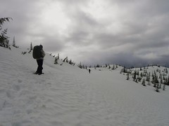
Steve at Widgeon Lake:
“Amazingly, there was still 5-10 ft of snow at the top of this trail (but only at the very top strangely). The journey was far tougher than we expected. Painful boat logistics. An almost not seaworthy inflatable boat for 2 people. A steep slippery root climb for last 2 km. Rain for 70% of it including the chilly snow camping. Even then Widgeon lake is worth a revisit. Though we could barely make out a view, I suspect that the lake islands and granite backdrop would be spectacular. As it was the ice was very interesting (very arctic like). Do this one at the end of the summer when it is dry and make sure to stop by the scenic falls too. This trail could be one of the greats but given how tough it was for me, and how bad the rain and visibility were, my particular experience was only a marginal thumbs up and that was mainly because of the great company and good attitude in adversity (Jamie, Janice, Steve and Kevin).”
Category Archives: Backpacking
Mt Gandalf 21/05/11
Ben at the Brian Waddington Hut:
“Despite the dramatic disappearance of the sun this weekend, our group of five met up and headed north with hopes of finding clearer skies. The road to Birkenhead Lake was clear and in good shape all the way to the lake. We turned off at the branch immediately before the gate to the campground and parked nearby, facing 6.6 km of logging road to walk to the trailhead. Along the way we passed up a VOC group heading up with skis on their backs. At the end of the road we had lunch and let the skiers take the lead. The trail was short and very well marked as it winds up the forest along Phelix Creek. It was however challenging in the soft melting snow with heavy packs. Eventually we crested a small rise to see Long Lake and the hut awaiting us at the far side. The weather had been grey all day and it didn’t look like the situation was any more promising up here. The hut deserves its good reputation. The evening was a relaxing mix of cooking, reading selections from the library, and enjoying the skiers’ renditions of old Bob Dylan songs on the guitar.
The next morning the snow was falling and we left the hut to stretch our legs. We had no real expectation of reaching any summits, but we decided to make for Gandalf-Peregrine col and see what things looked like. After a couple of hours we found ourselves at the col having the turn around time discussion. We had plenty of extra time so we decided to invest another hour and take it a step at a time. We began to switch back up the end of the ridge leading to Mount Gandalf. We couldn’t see much but we knew that up there somewhere the white wizard was waiting. Progress was steady thanks to Brad’s trail breaking effort, and before we knew it we found ourselves standing below huge boulders. With less than 100m to gain, we knew we must be close. From here Pavel lead us on a true showshoe scramble as we moved up bare slabs, boulders, and the snow that filled the gaps between, not bothering to stop and remove the snowshoes. One final block split the group into three as we picked our preferred routes over or around the rock. After converging and counting heads, we moved on. Then out of the mist appeared the great unmistakable flake standing like the final stone on some great summit cairn. We were there! Congratulations all around! A huge thanks to Brad, Pavel, Rob, and Darcy for their contributions to this very memorable trip.”

Panther Peak 21/05/11
Ahmad on Panther Peak:
“I was first surprised by the lack of signage to the park. I expected at least the regular provincial sign that I am used to seeing in provincial parks. Second, I was surprised by the lack of people especially for the long weekend. There are four cabins in the park and I think the park is underrated. We only saw 6 people in total.
I wasn’t aware of NcNair Cabin which was a treat to find near our destination. It seems most people in winter head to Edwards Cabin and some to Steele Cabin. The trail to Edwards Lake was broken but there was again lack of markers but might just hidden in snow. It could be better in summer.
After Edwards Cabin, we broke the trail towards Chapman Lake. The trail crosses Chapman Creek about half way but we missed the turn and we became on the other side of the lake. We reached a creek that we couldn’t cross. We had four options: return to Edwards Cabin, turn back and look for the bridge that we missed, camp where we were, or cross Chapman Lake. We chose the last one. The lake was melting in some sections but we managed to cross it without a problem but I expect it will not be crossable any more soon. McNair Cabin was in good condition and it is located truly in serene location.
Our objective was to summit Panther but I was pretty exhausted from the night before. I also had some concerns of crossing the lake on the next day and the tight schedule for the ferry. I think this is an awesome place to spend an overnight if not more.
Photos, movies, and GPS track on Live Trails.”
Taylor Meadows 27/11/10
Chris M. winter camping at Garibaldi Lake:
“We broke trail the entire way. Along the road, up the trail, in the meadows and up the ridge. Around 25 km round trip. Scott and Ian were in snowshoes. I skied. I was so tired I buried my heavy tent at the 4-km marker and decided to sleep in the shelter. We missed sunset. Exhausted, we played cards, went to sleep early and still we missed sunrise. We woke up to frozen ski boots and gaiters. After skinning up the ridge, just as the views opened up, along they came including Robert!? – a Wanderung member who decided our tracks looked better than breaking trail over to Panorama. Smart choice. After stopping with a beautiful view of Black Tusk another Wanderunger, Adrien showed up!! The morning had been a bright blue but the clouds now started to roll in. Skiing down in 2 feet of powder was dreamy.”
Semaphore Lakes 16/10/10
Ben at Semaphore Lakes:
“The time of year was near perfect for a trip to this area. While the lower portion of the trail was very muddy, the ground in the bowl containing the lakes was nicely frozen. There was a light blanket of snow varying from sparse patches in the sunny spots to several inches in the shade of the ridges. It was just enough to add beauty to the alpine scenes without making travel difficult. After establishing camp we made our way up Locomotive Mountain. We followed the gentle southern ridge which cannot be seen from the lakes. The route was mostly snow-covered talus and easy to follow. On the summit, the air was cold and clear, and the views were exceptional. Although the sun set well before we made it back to camp, the half moon was bright on the snow and we had no problems. After a very chilly night we were happy to see the sun crest over the ridge at around 10:00. On this day we went for a nice walk along the ridge to the east, and then meandered our way around the lakes and back to the trail. Thanks to Bill and Mazy for joining me and contributing to this great trip.”
Elfin Lakes 18/09/10
Malin at Elfin Lakes:
“Six adventurous Wanderung members braved wet weather and vehicle problems on Saturday morning and headed up to Elfin Lakes for the weekend. Light rain fell continuously on our way up to the Red Heather hut, but the showers got less frequent after that. By the time we arrived at Elfin Lakes the sun actually poked through the clouds and we had lunch by the lake. After lunch we left our heavy bags in the hut and headed towards the saddle between the Gargoyles and Columnar Peak. The trail was incredibly slippery, but the hike well worth it as the clouds started burning off when we reached the saddle. From the saddle we headed up to the Gargoyles, where we enjoyed great views of the Diamond Head, Diamond Glacier, Opal Cone and Elfin Lakes. Despite the wet weather the hut filled up completely and it was nice to retreat to the quiet tents. In the morning we headed towards the Opal Cone. Surprisingly we made it all the
way, despite some heavy rain and the washed out trail. We even had some nice views! The bridge over Ring Creek was in place, but people should always check: http://www.env.gov.bc.ca/bcparks/explore/parkpgs/garibaldi/trail_report.pdf for the most current information. Thanks to Rob for the directions to the
Cone and to everyone else who joined me on this great adventure.”
Singing Pass 28/08/10
Su-Laine hiking the Musical Bumps via Singing Pass:
“Do this trip soon! Eight of us headed up the steady gradient of the Singing Pass trail on Saturday, towards the meadows where a variety of alpine flowers were in bloom and more had yet to open. Russet Lake had plenty of excellent camping spots. It got cold: we measured minus 2 degrees at night while we were still awake! On Sunday six of us day-hiked to various altitudes on Fissile Peak in glorious sunshine. It’s a tricky scramble and only one of us got to the top, but even a partial ascent gave excellent views.
After waiting out a spell of bad weather at the Russet Lake hut, we hiked out in temporarily less-bad weather along the Musical Bumps trail. I discovered that a scrambling helmet is fun to wear in a hailstorm – you hear the clatter of hail while keeping dry and cozy. The fog cleared and the sun came out occasionally, enough to appreciate the beauty of the region, which included black bears and gregarious marmots. The (free) gondola to the village was scheduled to run until the late evening that day, so it was past 7pm by the time we got to the Dubh Linn Gate pub for dinner. The gondola is scheduled to run until late a few more times this summer (Sept 3, 4, and 5), but call Whistler Guest Services (1-800-766-0449) to confirm.
Thanks to everyone for making this such a fun trip with great company.”
Lost Valley 07/08/10
Chris exploring the Lost Valley:
“The weather may not have been ideal and the bugs fairly bad but we had a nice surprise which more than balanced this trip. With no signups, Cara and I were free to join a WCWC trail building trip that was, coincidentally, also going up the Wade Creek trail. Both the Haylmore FSR and the various Wade Creek roads are in excellent-to-decent 2wd condition and it’s possible to park within 1 km of the bridge over the creek. The trail is steep with an average grade of at least 15% and sticking to the ridge crest even when it doesn’t seem like a good idea. There’s some blowdown around the mid-point of the route but it’s well flagged. The WCWC is improving the trail by adding switchbacks when needed. The final stretch side-hills above steep slopes. The trail fades just below the lakes near the pass. With a bit of trail-building thrown in, we got to the lakes in about 5.5 hours. From the pass, we wandered ridges and meadows to reach deep into Lost Valley to its headwaters. You need to pick your ridge ascents and descents carefully. The lower meadows were lush with plants to our shoulders at times and footing was tricky because we couldn’t see our feet. Along with more ptarmigan and pika encounters, the highlight of the trip was the multiple wolf sightings we made (3 out of 4 days were wolf days) including watching a litter of pups play in a meadow for an hour or so.”
Manning Park 31/07/10
Michelle on the Skyline and Silverdaisy trails:
“No rest for the wicked! Three early mornings allowed us to maximize the mileage on this 500 something cumulative km trek spanning two provincial parks. Skyline as a cross over hike was a fun and unique experience with 5 hikers from Skagit and 4 hikers from Manning enjoying more sunshine than drizzle (and just a flash of lightning) before meeting up at Mowich for an enjoyable evening together. West of Mowich, Skyline does offer fine views of Ross Lake and the North Cascades. However continual views of Hozameen, endless peaks, valleys and the Lightning Lakes chain, kilometres of wildflower meadows, access to ascend Lone Goat and Snow Camp Mountain (a fine lunch spot enjoyed by both groups) is afforded by Skyline east of Mowich. Both groups also tackled a portion of the Hozameen Ridge trail 900 m west of Mowich (a spectacular ridge walk on a clear day). Reunited in Manning a dip in the river, some grub at the East Gate Diner, some refreshments from the General Store and cards at the Hamptons rejuvenated our band.
Of note – still some water trickling at Mowich, but I was glad I packed in all my water. Bugs (particularly flies) are better than last year in Manning, but were enough of a nuisance (as proved by my swollen eyelid bite). The snow is ALL gone and flower season should hit full bloom in the next few weeks.
The Silverdaisy trail is in fine shape, though easy to get side tracked and wander off in the beautiful meadows up top (pay attention and look sharp for the flagging). Silverdaisy makes you work for it, but the payoff of alpine meadows with a panorama of mountain views made for a very satisfied group. Mental or GPS breadcrumbs are useful for descent from the summit (easy to loose the route you travelled in on with little or no meadow footbed). The through and through hike may have shaved some time but navigation to Cayuse took effort and required GPS (lots of roads, lots of choices, little or no distinguishment on screen between active roads and now tree choked roads). An enjoyable adventure, but best (and more scenic) to just return via Sumallo Grove.
Summary: Nine enthusiastic hikers – check! Two cars + two phenomenally dedicated drivers – check! Two through and through hikes completed- check! Several frosty shakes and slices of pie consumed. Nine content hikers.
PS It’s a small world – 4 out of 8 groups on Skyline knew each other by 0–1 degree of separation, 2 groups of which were fellow Wanderungers.”
Graveyard Valley 01/07/10
Chris in Graveyard Valley (southern Chilcotins):
“Getting to the trailhead for this hike can be a challenge. We made it in a slightly lifted 4wd Tracker with AT tires. 2wds will find the going ok until some dried mud flows on the descent to Tyaughton Creek campsite – still doable but you might scrap. If you get past a waterbar near the top of a hill about 500 m north of the campsite, you’ll be able to drive to at least 13.3 km past the campsite. Beyond this point the puddles get bigger and 4wd with good tires are recommended (later in the year, you might be able to push it for another couple km to the top of the big hill). We took the Relay Creek trail to the cabin then went up the Little Paradise Creek trail, over the pass to Graveyard and down to the large meadow where the main creek is. All the trails were frequently boggy with snowmelt and there were frequent creek crossings (many unavoidable). We had 2 nights of sub-zero temperatures and a mixed bag of weather – some rain, some snow, some hail and some sun. We explored many of the ridges around Graveyard including Elbow Mtn (climbing to 2450 m barely touching snow). Almost ran into a grizzly in Little Paradise (there’s also a large one in Relay – saw some enormous prints), heard some wolves calling and saw lots of deer and marmots. On the way out, we travelled down to Graveyard Cabin (which is showing it’s age – I’d opt for a tent given the choice) and back along the Relay Creek trail.”