Category Archives: Backpacking

Hector Ferguson Lake 24/06/10

Cam at Hector Ferguson Lake:
“A completed mission to Hector Ferguson Lake: need I say more? The plan was hatched for a quick over nighter for a short and easy hike to Hector. Three brave souls in attendance.

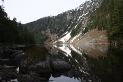
Thursday morning it was sprinkling a little bit but nothing out of the ordinary for Vancouver weather. Biked to 6.5 km mark, hiked to 9.5 km, forded Gold Creek twice and rejoined trail on east side. Forded again at 11 km to west side of Gold Creek, followed trail to bottom of drainage from 1502 and followed flags up. We missed the flags going to the NW out of 1502 creek towards drainage of HF lake. Bushwhacked up 1502 then turned west and joined up with HF lake. As many of the local hiking books describe the lake is pretty but the shore is far from inviting for overnighting. On Friday we followed the flagged route back to 1502 creek a much better route than what we took on Thursday.

Return distance 32-34 km, 650 m elevation gain, I measured 750 with my extra side trip.”

West Coast Trail 05/06/10

Su-Laine on the West Coast Trail:
“Yeah, we made it! Six days on the West Coast Trail went by quickly for our group, with one regret being that we didn’t make it a longer trip and visit the beaches of the south end. The southern 13 km of forest trail have no redeeming qualities whatsoever, and the next 9 km feel almost as pointless except for the satisfaction of having several dozen ladders and countless bottomless mud pits behind you. Despite improvements over the decades, this is still a tough trail. Good things to have are sturdy well-broken-in boots, tall gaiters, bicycle gloves, two poles each, and microspikes for slippery logs. You need balance and agility to get anywhere. After two long days trudging through the south end, the lovely beaches and faster hiking conditions of the north end were a joy. It’s a beautiful trail for gazing into tidepools, for swimming in creeks and waterfalls, and for exploring seaside rock formations.

As we’d hoped, the trail was comfortably uncrowded, and finding good camping spots and room in the metal bear boxes was no problem. The mice are definitely back, especially at Tsusiat Falls – don’t delay in getting your food to into the bear boxes in the evenings! One other thing to know is that Telus cell phones work on the trail but Fido ones apparently don’t.

We got to know our fellow south-to-north hikers a bit, enjoying their company at shared campfires and at a brilliant brunch at Tides and Trails restaurant on day six. Hiking times were very long on most days and there wasn’t much free time, but we took a break for burgers at Chez Monique and spent some unhurried time at the beach, and entertained ourselves by building a bridge across the Darling River. We managed to see some whale spouts but not much else in terms of rare wildlife. There was a sense that there is more to the trail than we could see that week, giving all three of us some desire to go back.

P.S. The Parks Canada staff said July and August are fully booked and that there are still some reservable dates in June. September is reportedly an excellent and uncrowded time to do the trail.”

Ladder

Wild Side Trail 22/05/10

Paige on the Wild Side Trail:
“Ten of us hiked the Wild Side Trail, which is a little known hike across Flores Island. It requires a water taxi ride from Tofino to Ahousaht, which is a First Nations town on Flores. The hike to Cow Bay is only 10 km through the forest with a good amount of beach walking for the tired or lazy. Not many people know about the hike, and you’re almost guaranteed to see bald eagles, otters, seals, sea lions and possibly bears or wolves.

It’s definitely worth making the trek out that way – the sunset at Cow Bay is gorgeous (see Chris M’s photo in the Wanderung Flickr Group) and we watched whales only a few feet from us while we collected mussels to eat at the campfire. It’s also possible to kayak there from Tofino.”

Cow Bay

Juan de Fuca Trail 21/05/10

Stephen P. on the Juan de Fuca Trail:
“Don’t Juan de Leave, the Juan de Fuca Trail – 2010 May Long Weekend…

Backpacks filled. Cars gassed. Ferries reserved. Off we go. Forty-seven km muddy trudging, suspension bridges, waterfalls, although more beach hiking would be nice. Chilly nights, many water sources, abundant gorgeous pictures, and cool ocean winds to cool you off while hiking. Trail descriptions claim 25 m elevation gain, this occurs over, and over, and over, again. I found this much easier on my beat up knees than the usual alpine hike, as the multiple descents were very short.

We avoided car accessible campsites to stay away from tent city high schoolers, our daily hike distances varied accordingly: 2, 19, 12 and 14 km.

Great campfires, unfortunate broken promises of sunrise yoga, laughter that echoed across the cool waters of Juan de Fuca Strait, on the fly doggie bag MacGyvered gaiters. Thanks to J, D, R, M, I-S, V, and S for making a memorable trip.”

Lower Stein Valley 15/05/10

Steve in the Lower Stein Valley:
“A well matched and fun team of 6 hikers went up to Skihist provincial park for a night and embarked up the Stein trail (to the suspension bridge) the next day. The roaring Stein River was at our side for most of the trip and the trail was not too challenging to be carrying an overnight pack (even the Devil’s Staircase was short enough to present no problems). It felt like an August hike! What a treat to get 25 C+, dry weather in mid-May.

We stayed at the Earl’s Cabin campsite but I have to say that the build-up over the years I’d heard about Stein was not fully warranted. It was nice, but nothing to put it on the world stage like it seems to be (similar to the WCT). However, there are three reasons that you might want to add this to your list:

  • Native pictographs – I’ve never seen these on any trail before (very cool!)
  • extend your season – when nothing else is doable, you can hike this trail in warmth much earlier (sometimes April)
  • warm up to backpack season

IMG_0747

Hector Ferguson Lake 15/05/10

Erez at Hector Ferguson Lake:
“This was a 2-day camping trip. Michele and I started hiking around 10:30. The first ~11 km of the trail are very well marked and we had no trouble getting to the Gold creek crossing. There are a few places where one needs to cross very minor creeks, but that is easily doable with no need to take the boots off. We set up camp at the sandy patches on the east side of Gold Creek, had lunch, and by 15:00 we continued to the lake. Gold Creek is now passable, with two branches to cross. The first crossing is wider but shallower and with no strong current. The second one is deeper and has a pretty strong current but with a stick and some careful stepping is not a problem. The level of the water was thigh-deep at the deepest place. After the creek the trail is more overgrown, but still pretty easy to follow. Very close to the lake there is a land slide and the trail is harder to find. You need to hike through the dry creek bed-rock a little up the slide and then veer left following the orange markers into the forest (thanks to Michele we added markers so this should be pretty obvious now). From other trip reports I read, I believe this is the place other people left the trail and got stuck. The marked trail does lead all the way to the lake. We stayed there for 1/2 an hour and hiked back to the camp for some nice dinner. This was an awesome trip.”

IMG_4833

Mt Frosty 10/09/09

Tracy on a frosty night on Mt Frosty:
“Ten people turned out for the Mt. Frosty overnighter: Chris M. (the organizer), Tracy, Brenda, Lana, Dorothy, Lucy, Jeff, Daniel, Paige, and Sebastian. It was a beautiful Saturday morning, but decidedly nippy out as we started from the Lightning Lakes parking lot. The plan was to camp in the larch meadows, but when we reached the aptly named Frosty Camp at 12:30, we discovered it was bitterly cold and made a group decision to set up there, since we’d be able to have a fire there. After setting up camp, we continued onto the beautiful golden larch meadows. The trail was quite slick due to ice; crampons would have been nice but everyone made it in their boots.

Once in the meadows, unfortunately Chris had to turn back due to increasing flu symptoms. A few others decided to join him on the journey home, having seen what a cold night it was going to be. Chris kindly waited while everyone continued with the rest of the group to the Frosty summit. After taking in the stunning 360 degree views, we turned around; some back to camp, some back to the car with Chris.

Chris left us a plethora of treats to enjoy: wine, cookies, and Thanksgiving ham. We shivered around a campfire that barely seemed to give off any heat at all. Huddling close together, we enjoyed Chris’s treats, except for the ham, which we saved for breakfast. There was some debate over who would sleep with the ham to keep it from freezing. In the end this job fell to Jeff, I think.

We estimate it reached -15 C overnight. In the morning we hustled out of there, looking forward to getting warm. A stop at the Chilliwack airport for its famous pies finished off the outing quite nicely.

Many thanks to Chris for organizing, and so sorry he couldn’t be there to shiver in the cold with us.”

Golden Ears 19/09/09

Heather on Golden Ears:
“Bob, John, and Heather did a shorter overnight trip, leaving Saturday afternoon and hiking 5.5 km up to Alder flats to camp. From there, they left the tents Sunday morning and hiked to the peak of Golden Ears, enjoying blueberries and watching the clouds come and go. The peak was clear of clouds with partial views to Pitt Lake and some of the mountains to the north. However, other clouds obstructed Mt. Robie Reid and the Fraser Valley, so the views weren’t quite as stunning as they could be. Unfortunately, the trail was the most littered with garbage of any provincial park that I’ve been in. This included the emergency shelter being a complete mess, and random garbage and graffiti everywhere else. Too bad. Sunday’s total distance, 18.5 km, took us 11 hours with a few nice breaks. A bit of a slog as a hike… I have previously done it in one day by mountain biking 6 km up the east canyon trail, stashing the bikes, crossing the river, and bushwacking up to the main trail, and I think I prefer that strategy to the 24 km slog.”

Russet Lake 22/08/09

Jennifer exploring the area around Russet Lake:
“Peter, Laura, Sandi, Michael and Jen all got an alpine start to backpack in to Russet Lake for three days. Via the valley we made our way up Cowboy Pass and down to the lake to set up camp. After a second lunch, we headed up Fissile Peak. Fissile was challenging. There were lots of loose crumbly rocks covered with gravel and quite a long stretch requiring good handholds (of which there were none) giving us a run for our money. We did make it to the top, using the first route described in the Scrambles Guide. The group slipped-n-slid back down the way we came, with a few bruises and scrapes (that shale is full of fossils but also quite sharp!) but no major mishaps. I would recommend helmets for sure (easy to knock rocks down, and we had some narrow misses). Day two followed a crystal clear night of stars. Clouds and some sun made our scramble up Whirlwind peak and on to Overlord Mountain more dramatic. Scampering onto the ridge was the only challenging part of Whirlwind which was otherwise a lot of up with spectacular views of Garibaldi and the Tantalus Range. Now that we’ve done it, we would recommend climbing up the middle moraine to get to the ridge. From Whirlwind we took the northern ridge up Refuse Peak to Overlord. The panorama of peaks and ice-fields filled our eyes and took our breath away. With a couple of exposed areas requiring some careful hand and foot moves, the route up was straight-forward. Back the same way over Whirlwind to avoid glacier travel brought us safely (albeit hungry) back to Russet Lake. We woke up frost-covered in the morning but the sun soon warmed us up (it’s toque, long john, and down vest weather already). Third day was a mellow sunny meander over the Musical Bumps to the lovely gondola which whisked us back to our cars. Potluck dinners and lots of laughs made an unbelievable setting that much better – thanks for a great trip!”

Slim-Nichols divide 02/08/09

Chris on the Slim-Nichols Divide:
“Well, that was an adventure! The usual route to the Chilcoten is over the Hurley but it was closed due to the Coppertop and Camel’s Back fires 2 days before we were to leave. The obvious alternate route is through Lillooet but the McLean fire was within 1km of town limits with evacuation imminent. So Cara, Lucy and I chose to drive over the Highline from D’arcy to Seton Portage and then over Mission Mountain to Highway 40 (this was just before the Seton, Spider Creek and Hell Creek fires were started / discovered). The Highline was not bad. The hill out of D’arcy might be too steep for some 2wd but there was a Ford Focus parked halfway along. The crux is a steepish hill with some loose rock about halfway along – timid drivers need not apply. Mission Mountain is even better – 2wd friendly but you have to like switchbacks (a lot). From Pemberton to Highway 40 was 2 h 10 min for us. Then it was on to Slim Creek road – probably in better shape than last year (2wd with some rough / rutted spots). The long drive and high water levels on Slim Creek changed our plans for day 1 and we decided to camp just before the meadows and cross over early on day 2. We managed to find the trail up the southern branch of Slim but lost it again. We camped in the high alpine near Slim Lakes and could see a couple of smoke plumes in the far east. The wind changed direction during the next night and the whole of day 3 – crossing over Sorcerer ridge and into the Nichols drainage – was smoky. Rain moved in that evening and was on and off until late morning of the next day when we climbed Glacierview Peak. Day 5 was mostly clear as we climbed into the top of the Nichols drainage, touched the edge of Griswold, dropped into Gun Valley and climbed back out over Wolverine Pass to Leckie Lake. Day 6 was very hazy with smoke as we returned to the car. In general, the area was very dry with most non-glacier-fed creeks having dried up and ponds at low levels. Despite some signs of large mammals, we saw only marmots and smaller animals. The real adventure started when we drove back to Gold Bridge to find all access out of the community closed. We ate supper at the hotel and found a campground that wasn’t closed for the night. The next day we hit up the gas station, library, store and hotel looking for information on whether there would be a scheduled convoy leaving for Lillooet (there had been one on the previous day). While we waited, we ran into a couple members of a Land Cruiser club returning from a 2-week expedition into the Chilcotin (we had seen them on our previous trip from a distant vantage point on Battlement Ridge as they climbed the old mining roads on Pallisade Bluff). These guys are serious offroaders with stories of crossing 1 metre deep creeks and carrying spare axles! While we were at the hotel, word came that the Hurley was reopening and there was a mad dash for vehicles and we were off up the Hurley before conditions changed again. We finally arrived in Vancouver 20 hours later than planned.”