
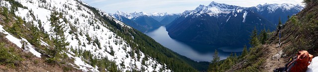
Chris N. at Cheakamus Lake:
“I always think of Cheakamus Lake as an easy stroll suitable for hikers from 1 to 101. So I was surprised to find several substantial blowdowns across the trail. Some of the logs are up to 1 metre wide and, given that these were tall trees, going around them would be even more difficult. There are 4-5 trees across the trail before the lake and a few more beyond that. Otherwise the trail is in good shape and there’s no snow at all. There were a number of campers heading to Singing Creek and beyond but no-one camping at the north end of the lake. We ventured beyond Singing Creek for about an hour along a rough trail to the remains (just foundations and some rusted metal) of a tiny cabin.”
Yearly Archives: 2016
Harrison Hut, 6 May 2016
Colleen C. at Harrison Hut/Meager Hot Springs:
“Thanks to our two capable 4WD drivers we made it all the way to the trailhead. There is active logging in this area and the road was being improved in preparation of more. I always feel torn by this. On the one hand it can be hard to see the results of that industry, but on the other hand I use paper products and without these roads I wouldn’t be able to access the mountains that I love to be in.
We made it up to the hut the first day (which we had all to ourselves!) but it was a long slog and just the first of three long days. We went in and out of snow the whole way up. Three made it to the hut without using snowshoes, but two of us put them on after the Barr Creek crossing. The snow will be gone soon which will likely make the crossings more challenging.
The next day we split into two groups. Three summitted Frozen Boot Peak, a steep hike up then a reportedly enjoyable ridgewalk. Fred and I made a loop up to Two Doctors Peak / Mt Andropov with a side goal of seeing the Meager Obelisk. We found it as we were coming down from the summit, tucked in a small cirque. We admired it from the top of the cliffs, then continued over to the col by Pine Peak and back down to the hut. Sometime while we were gone, a bear walked over our tracks near the hut, but we didn’t see one then.
Each group had a walkie talkie so we were able to communicate throughout the day, still we were pleased that everyone got back by the appointed time. We packed up and headed down to the hot springs, getting there just after dark. The hot springs are lovely but popular, at least 30 people were already there. If you choose to visit this site, please not only practice leave no trace but also do your part to maintain the pools – there is no one else to do it for you!
The last day, we hiked out and started the long drive back to Vancouver. A black bear was seen from the trail and another on the logging road driving out. Plus we saw many frogs!
Huge thanks to the UBC Varsity Outdoor Club (VOC). We all paid the hut fee and didn’t use any wood, but that feels insufficient compared to the work involved in maintaining an outhouse, hut and trail. A particular thanks to one of our group who has helped out with one of the work parties. Whenever you clamber over a log with a chainsaw cut in it to make it easier and guide your steps, you’ll appreciate his handiwork!”
Orcas Island, 29 Apr 2016
Stephen H. on Orcas Island:
“Three glorious days in the San Juan Islands. Rasham, Ino, and Anna joined me on this no-reservations car camping trip south of the border. Day 1: Hiking to Turtlehead rewarded us with stunning views of the Salish Sea. Day 2: A grand loop up and down Mounts Constitution and Pickett granted us more spectacular views, forest walking, and a visit to a stone tower on the former summit. Day 3: We did a short walk to Cascade Falls before hitting the ferry back to Anacortes. All of these hikes are highly recommended. Our original plan was to camp at Mountain Lake. It was full, so we took a spot at the Midway campground by Cascade Lake, which had flush toilets. One trip highlight: seeing the broken soda fountain overflow with root beer on the ferry over. Another: a barred owl hung out with us at camp for a bit. Also: all the pop music we listened to all weekend.”
Mt Kelly, 17 Apr 2016
Phil A. on Mt Kelly:
“Lured by blue skies and warm temperatures, we set out to conquer Mount Kelly and the ridge to Nordheim Peak in Manning Park. We attacked from Allison Pass (N49° 06.924′ W120° 51.805′). The road had snow from the get go. After getting off track due to some fallen trees we had to bushwhack back on course. At the end of the road, the trail through the woods to the peak of Mount Kelly was slightly difficult to follow due to inconsistent flagging. Once at the peak, the trees thinned out and we easily navigated along the snow-covered ridge (which progressively slushed up in the spring sun). We then walked almost to Nordheim Peak to luxuriate in the sunshine before heading back.
Total elevation gain: 1400 m.
Snowline: Dependent on the side of the mountain, but the road was covered from the road/trail up. Snowshoes necessary.
Distance: 18 km.
Total Time: 7.5 hrs including lunch, breaks, and faffing.”
Lindeman Lake, 16 Apr 2016
Andrew W. at Radium Flora Lindeman Lake:
“It was a last minute callout with some last minute changes due to snow.
First up: Radium Lake. One look at the snow level and that idea was quickly changed. Second up: Flora. We got 3/4 of the way there (after many a switchback) but then encountered deeper snow (2-3 ft or so) than expected so a return to base was the wisest course of action. Naturally, we were equipped to camp and camp we did. Lindeman Lake was relatively quiet and a refreshing night.
Pics on the Flickr pool as per usual.”
Hut Lake, 9 Apr 2016
Chris N. at Hut Lake:
“Despite reports that the area was closed to vehicles, the gate at Levette Lake was open and we encountered a party on ATV and dirt-bikes and another in a convoy of 4wd. The road is 2wd to Evans Lake and, if you are determined, you can push up the steeper rougher bits to Levette Lake (or park on the roadside part way). Beyond the gate requires 4wd. There is a short stretch of rock crawling calibre at the cell tower. Hut Lake is unremarkable but it was a joy to camp without snow this early in the season. Some industrial activity was audible from nearby Paradise Valley. On the first day, we explored the old roads to the north. One road follows the north shore of Hut Lake before becoming a creek bed and heading up. Following this, you can visit two other lakes – one with a rough camping area and the other with a rope swing – before the road ends. All other roads quickly disappear into undergrowth. On day two, we bushwhacked around Hut Lake and found some very pleasant first growth forest on the south and east sides of the lake. We also checked out another lake to the west and followed an old fishing path for part of the way. On the way back, we popped in at Levette Lake which has an amazing view of the Tantalus Range but were treated to more industrial noise pollution. I have heard this area is very busy in the summer but was largely empty at this time of year.”
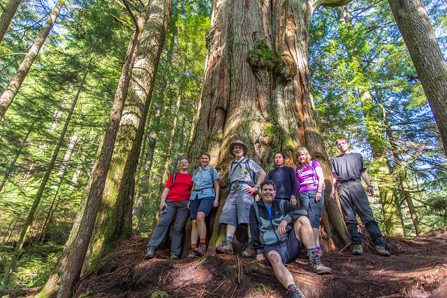
Kennedy Falls, 2 Apr 2016
Bob H. at Kennedy Falls:
“This is a great hike with two points of interest. First, is the big cedar tree, which has been estimated at over 600 years old; the second is Kennedy Falls. Don’t let the length and elevation gain of 170 m fool you for this hike. There are many ups and downs on this trail making the cumulative elevation gain 750 m. The length of the trail is 5 km, so the return total is 10 km. The trail traverses the west slope of Lynn Valley and you will find the big cedar tree 3.3 km from the start; also of note – the big cedar tree is less than 100 m from Lynn Creek. The cedar tree is massive and the only reason I think why it was spared from the saw in the early 1900s, when the whole area was logged, is that there was no saw large enough! The end of the trail marks Kennedy Falls, which is spectacular and fills the air with wind, mist and rainbows. There is a new parking lot at the trailhead on Mountain Highway, which fills up fast, so get there early. This is a very popular mountain biking area.
Blog post here: http://www.buntzenlake.ca/big-cedar-trail-and-kennedy-falls
Full Flickr photo album of hike here: https://flic.kr/s/aHskxGD5Pg“
Eagle Bluffs, 28 Mar 2016
Colleen C. at Eagle Bluffs:
“Glorious day to be on a mountain – spring is certainly upon us!
The air was cool through the forest on the way up, keeping the sweat at bay, but was balmy on top. No biting bugs out yet so we basked comfortably in the sun enjoying the views of the tankers, islands, ferries, and several eagles & ravens gliding in the thermals. Lots of grouse are out, and we saw a snail!
There were only tiny patches of snow in a few sheltered spots at the bluffs (just enough for snowballs but you had to work at it). We met one person who had come from the Cypress side, she reported little snow and just wore boots. That said, there are recent reports of heavy snow on other North Shore peaks, so do your best to get current info and be prepared. Spring can be capricious!
This was my first time doing this hike by transit and it worked out well. Take the 250 or 257 to the overpass just before descending into Horseshoe Bay. From there it’s a careful crossing of Horseshoe Bay Dr and short walk back to the Black Mountain trailhead.”
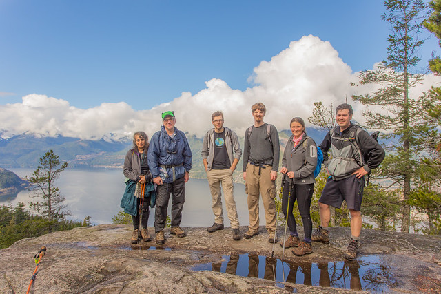
Upper Shannon Falls, 25 Mar 2016
Bob H. at Upper Shannon Falls:
“With a forecast all week for sun for Friday, expectations were high. A little concern about 5 mins from the parking lot, when it rained slightly, but the clouds parted and we were treated with lots of sun today.
Upper Shannon Falls is the 3rd highest waterfall in British Columbia and the hike to the top is well worth it. Today, our group of six parked in the Shannon Falls parking lot, but you can also park in the parking lot for the Sea to Sky Gondola, a short distance to the north. The initial part of the trail is shared with the trail for the Stawamus Chief hike. If you park in the Shannon Falls parking lot, you can see the bottom of the falls before your ascent. The trail is well maintained by BC Parks and there a few bridges to cross. Sections of the trail are steep, with some parts having nicely placed cobbles for steps. The trail was quite busy today and there were about 30 people at the top viewpoint.
The trail rises steeply and there are a couple of viewpoints before the top. There is also a section of the falls, where you can get very close. There is also a nice pool of water in the creek, where you could go in – in the summer, but I would imagine the water is very cold all year. At the top, you are rewarded with an amazing view of the end of Howe Sound, the Stawamus Chief and Squamish. The bluff at the top is a large area and accommodates several people.
Overall, the day turned out perfect and the group really enjoyed the hike.
Blog post here: http://www.buntzenlake.ca/upper-shannon-falls/
Full Flickr photo album of hike here: https://flic.kr/s/aHsktHWSzp“
Phyllis and Marion Lakes, 13 Mar 2016
Chris N. at Phyllis and Marion Lakes:
“We had a full compliment of hikers for this not-very-spectacular destination (organizers: there is a thirst for hikes so do some callouts!). We parked just at the base of the Phyllis Creek road just north of the Furry Creek golf course. The yellow gate at the bottom of the road was locked and, if open, can’t be trusted to be so when you return so don’t drive through it. ATVs have build an elaborate route around the gate and we encountered 2 ATVs. Also met 2 trucks out exploring (not sure how they got up there).
I usually use iMapBC to create detailed 1:20000 maps but I am starting to encounter issues with the age of some of the road data. This trip highlighted those issues. We encountered several recent forks that just weren’t on iMapBC and difficult to see on Google Earth. There’s a triple fork around 1 km – take the leftmost road. After crossing Phyllis Creek, there are new roads on the right in several places and signs warn of active logging.
The lakes themselves are not much to look at but rocky bluffs straight out of an old Chinese print loomed over them and were pretty cool. The second lake has a dodgy makeshift dock. It took just 2 hours to reach a large fence and gate blocking access into the Capilano watershed just past the lakes (I am sure you could get around it if you really wanted to). We had a quick lunch in some wet snow and headed back just as it started to rain. Got some good use our of our waterproof clothing. We were back at the cars in time to drive the short distance to Galileo’s Coffee in Britannia Beach before they closed (3 pm during the winter).”