
Michelle at Brohm Lake and Forest:
“This 2 for 1 hike offered a pleasant casual forest hike on a beautiful sunny day. Though the entrance to Brohm Lake Interpretive Forest doesn’t have its own sign/turning lane (unlike Brohm Lake) it’s easily spotted: after Alice Lake look for a yellow gate on your left with a signboard map right next to it. Signage/trail markers were excellent all along the two inter-linking trail systems (and nary a blow down!). The “fire lookout” offered by far the best views and proved to be a highlight and a most suitable lunch spot. The upper High Trail and Western shore trail of Brohm Lake (a surprisingly large and enjoyable lake) were the most pleasant in both terrain and lake views from above, although the easiest water access points were on the eastern bluffs close to the lake parking lot on the #99 side. You never know what’s hiding just off the shoulder of the highway.“
Tag Archives: Squamish
Levette Lake 24/05/09
Heather on the Levette Lake loop:
“Kitka, Paul, Janice, Bob and Heather had a great day exploring the Levette Lake loop north of Squamish. The sun was hot, the views fantastic, the air smelled of pine trees, and the wildflowers were in bloom. One of us even went for a breathtaking swim in Levette Lake during the leisurely lunch stop. A pleasant, relaxing hike with lots of variety in the forest and look-out spots.”

Cheakamus Canyon 09/05/09
Susie at Cheakamus Canyon:
“Susie, Angela, Louise and Noman met on a gorgeous Saturday morning for this very enjoyable hike. With Highway 99 open through the contentious Eagle Bluffs, travel to Squamish is now fast and easy. We drove to the end of the road in Paradise Valley (we had a 4×4, but saw 4x2s at the parking spot), and started up the trail to cross the BC Rail line. That dealt with most of the (minimal) elevation gain, and soon we were at Starvation Lake, very pretty on a sunny morning with a couple of Canada geese posing in the middle. Shortly after we entered the canyon area, via an exciting piece of trail where you are literally walking on air … fortunately over some sturdy netting securely fastened to the cliff. The sound of the Cheakamus River pounding through the canyon was with us for the rest of our trip. It is impressive looking down at the railway line below and marvelling at the engineering required to build it. The trail must pass through a rain shadow, because the vegetation is more reminiscent of the Interior than coastal rain forest. The trail eventually peters out at Highway 99, so we turned around before the traffic noise was too great. A lovely relaxing hike, although we agreed it probably should be classified as a “wike” (walk/hike). It’s worth noting that this trail is snow free 99% of the year.”
Levette Lake 09/05/09
Chris on the Skyline and Copperbush Trails near Levette Lake:
“Cara, Ivy, Jennifer, Susan, and Tao joined me on a leisurely ramble around the Skyline/Copperbush trails with a sidetrip to Levette Lake. Don’t believe the bad reports for this trail that you might read on the Internet. Granted, if you plan on going in a clockwise direction, the start of the trail is tricky to find and looks a bit overgrown but it’s fine after 100 m – just watch for the painted can lids nailed to trees. The lookouts have grown in a bit (like at Diez Vistas) but the views are still great (Tantalus in your face) and the trail is quiet. Levette Lake is popular and we encountered a large car-camping group up there. Hanging out at the lake is a bit cooler than at the bluffs (like Silver Summit) to the south.”
Upper Shannon Falls 09/05/09
Su-Laine at Upper Shannon Falls:
“Upper Shannon Falls is an underrated trail in two respects. Where else, at 12:30 PM on a gorgeous Saturday, can you have an entire summit to yourself with beautiful views over Howe Sound? Other than the 185 m of staircase that it shares with the Stawamus Chief trail, this hike is uncrowded enough that you can feel that you’re getting away from it all. The trail is also underrated, though, in terms of difficulty. Don’t be fooled by the fact that it’s listed in a book called “109 Walks” or by memories of family picnics in the lower Shannon Falls area – on average this trail is about as steep as The Lions.
Our planned Cheakamus Lake trip didn’t happen. We got about 3 km into the 8.5 km logging road off Hwy 99 and had to turn back because of snow on the road. Vehicles with high clearance might be able to get to the trailhead, but I’m not sure. A stroll in Whistler after dinner took its place as our second hike of the day.”

Shannon Falls and the Chief 03/05/09
Heather at Upper Shannon Falls and the Chief:
“Nine of us outwitted the weather report and had a great day doing a double hike to upper Shannon Falls and then the 2nd and 3rd summit of the Stawamus Chief in Squamish. The group included a nice mix – from “first hike in Canada” to our local “Mountain Meister”, plus three other Wanderungers that we bumped into along the way. After all these years, I’d forgotten how steep the Chief is, but we all got a good workout and took extended lunch breaks on the bluffs overlooking Howe Sound and then on the second peak while watching the cute chipmunks running around. The chains and ladders between 1st and 2nd summit add excitement to the way up, and the loop trail between 2nd and 3rd summits is an easier, varied way of getting down. All of us enjoyed a good early season hike and great company.”
Cloudburst Mtn 02/05/09
Ahmad on Cloudburst Mountain:
“Dan, Trevor, Tamsyn, and I summited after six hours of hiking. The trip started by a maze of logging roads. We found the right one fairly soon after two trial-and-errors. I parked just before the snow line which was at 600 m altitude and 3.2 km from start of the logging road. We walked along the road which ends at 7 km. No marker after that. The next stage was to find a reasonable opening in steep rocky slopes which perhaps was the hardest part of our hike. Once we got to altitude 1200 m snow quality improved, slopes ranged from gentle to steep (but not too steep), and it was fun to snowshoe. There is only one short very steep section to gain the summit ridge. Route finding was essential. On the way back, We slid almost 400 m of elevation. It took us 4 hours to get back to the car.”
Elaho Valley 21/12/08
Christian at Elaho Valley:
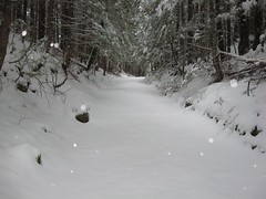
“After 1 hour of white-knuckle driving on unplowed highways before dawn, Stuart and I were on edge, as we were each feeling apprehensive about this trip!! We each traveled from different places to reach Squamish. Along the way, we encountered ground blizzards, covered signs, and could not see the edges of the road at times. We met at the Tim Hortons in Squamish and chatted about the weather and conditions before dawn. By dawn, the wind was gone and visibility was great. With a safety plan in mind of being back at the car before dark, we set out for the Elaho Main road. We saw some amazing eagles along the way. I was surprised to see six eagles in one tree (see Flickr). By the time we reached 28 mile, the snow was deep enough that it limited our vehicle speed to 25 km/h. We calculated that we would be spending more time driving than hiking. No fun there! So we turned back. Quickly found a great alternate hike at Alice Lake park. We decided to do the 8 km Lake loop. We broke trail for two hours and had a marvelous time. On our hike in the park, we encountered many families with their little pre-schoolers taking advantage of the small toboggan hills. It was a great day to be out! After our 2 hour hike around the four lakes, we went to the Brackendale coffee shop. We easily chatted away two hours of the day, long before dusk. All and all, a good time spent in Squamish on the Winter Solstice.”
Alpen Mountain 14/12/08
Chris on Alpen Mountain:
“Cara, Darcy, Dean, Mathieu, Roberto, Siegfried and Tania joined me in a search for the Hidden Valley Cabin on Alpen Mountain just east of Squamish. The Mamquam River Main (not the same road as the Mamquam Road that accesses the Elfin Lakes trail – this one is unsigned and just after the parking for the Chief) seems to see a fair amount of local traffic and was drivable to the Alpen Rd. The gate here was open so we drove in and parked just short of the first waterbar (200–300 metres up). Despite ferocious winds on the 99 and in Squamish, we encountered only light breezes even in exposed areas. But temperatures averaged around -10 C. We followed the main road but made a wrong turn about half way up (there are a lot of spurs) which lead us to a dead-end. After an attempt to cross-country to the main road, we gave up and back-tracked to the main road. Part of our party headed higher but still didn’t reach the cabin (locals said that it would have taken 4 – 4.5 hrs from the bottom). The snow varied from a couple inches at the cars to 2 feet of weightless powder around 1200 m.”
