
Diana on Hollyburn Peak:
“Our group dwindled down to 6 by the time of the hike but it was an enthusiastic group and a terrific day with a mix of sun and clouds, the perfect temperature for a short but relatively steep hike. We were surprised by the amount of snow still on the trail, probably from about 1000 m upwards, slowing down our pace a bit as we tried not to go through the edges of the melting snowmass or slip and fall. But the snow did allow us to make a miniature snowman at the summit with a banana peel wig, mini-carrot nose and wasabi peas for eyes (and yes, we did dismantle it and pack out our garbage before leaving!) The views from the summit were well worth the the slog through the snow and occasionally through scrub & brambles to avoid muddy/swampy patches on the trail, presumably wet from melting snow.”
All posts by andy
Brandywine Mountain 13/07/08
Andrew R. on Brandywine Mountain:
“After a couple of days of re-scheduling two of us finally got out to Brandywine on Sunday. It was almost a no-go when we reached the road to the trail-head only to find it has been blocked! The new access is via the Callaghan Valley road 30 seconds further down the highway (from here you can join up with the old road). The road is in good shape and we had no trouble getting to within 700 metres of the trailhead (any truck or 4×4 could reach the trailhead proper). At a leisurely pace we reached the meadows in 1 hour 45 minutes and then continued to the north end of the meadows where we started the ascent to the summit ridge. The meadows still have a bit of snow but not as much as I was expecting and I think they will be completely clear within a week or two. After a long climb up steep snow slopes we made the summit ridge for eye-popping views of just about every mountain in the area (the stegosaurus-like Mt. Fee is especially impressive). We scrambled the ridge for a bit but stopped just short of the summit as we were running short on time. The descent from the ridge back to the meadows (650 m vertical) was one long bum-slide. 1:15 hours up… 5 minutes down! All in all a great day out with great weather and great company.”
Capilano Canyon 13/07/08
Dana in Capilano Canyon:
“Dare I say my first organized (and last-minute) hike went very well! Seven of us ventured out on a very warm Sunday morning for Capilano Canyon on the border of West and North Vancouver. Well-maintained trails led us to our first viewpoint of the granite cliffs on the east side of the canyon, and Cleveland Dam made a great place for refueling with snacks and water. Our route back took us past the fish hatchery and across a small bridge. As a short hike, not too much more to report besides the very warm weather which likely made this hike quite suitable in terms of length/difficulty. Great company and a great way to spent part of the day.”
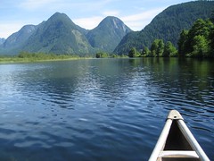
Lightning Lakes 13/07/08
Carollyne at Lightning Lakes:
“Although a group of four dwindled to two by 7:45, Daniel and I had a great day at Lightning Lakes. We made good time and had lunch in the shade of the cottonwoods at the end of the Thunder Lake trail. The beautiful blue-green lakes are almost constant companions all the way. Between Strike and Thunder Lakes, the trail revealed an astonishing number and variety of alpine flowers – as well as the huge rockslides. It was well worth the extra 6 km. On an otherwise hot day, a strong breeze kept us comfortable and kept the few black flies, deer flies and mosquitoes from being bothersome. A few canoeists, two tubby boat fishermen and four small groups of hikers were the only people we saw until the kids jumping off Rainbow Bridge near the end of our hike. With frequent photo stops and lunch, the hike took 7.5 hours.”
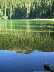
Radium Lake 12/07/08
Tyler at Radium Lake:
“We got to Chilliwack Provincial Park at 10 am. We were going to park in the maintenance yard but it was full so we parked our cars in the day parking. We set off down the trail and over the bridge to Radium Lake trailhead with Kate, Heather, Bob, Gerard, Joey, Ribeka, and myself. The trail more or less follows the Radium Creek drainage, crossing the creek a few times, but there is a nice network of bridges and a suspension bridge made up of duct tape and old rope, so fording is not necessary. The trail is well marked to Radium Lake. We arrived at the lake and noticed there were tents all over so we set up our tents on the other side of the lake. We were able to find a dry spot by the creek.
Awesome campsite as it was lake property. Radium Lake is a shallow lake with an emerald green color. There used to be a shelter there, but the roof has long since caved in, so it’s no longer useable but exciting to see. On Sunday morning we decided to leave our gear and go on a day hike up the mountain to Mt Webb. I really recommend this hike to the peak as the views are to die for and you can see Mt Baker and other peaks in the USA. When leaving that day I found out the wind took three of our tents and blew them into the creek. I got it the worst as all my gear was soaked. I was able to dry everything out but my sleeping bag was a bit damp. We didn’t leave camp till 4 pm and weren’t down the mountain till 7 pm. Everyone got down safe.
The weather up there was amazing with no snow, but some still around the peak of Mt Webb.”
Mt Frosty 12/07/08
Ahmad on Mt Frosty:
“Five of us did Frosty’s east peak in 9.25 hours. The trail is well-graded, scenic, and has all types of terrains. It goes through old trees, many flowers, a wide and open alpine area, rock slide, and a peak. At the campground, there are many mosquito campers who were eager to meet us. The shelter is primitive and the creek beside it seems that it will dry up soon. The peak is quite wide. It fits 20 people easily and it has superb views. We spent 1 1/2 hours hanging out there. At the end, some of us took a quick swim in lightning cold water in Lightning Lake. Thanks for Keith and Ryan for their snow report of the trail. No much snow left now. We encountered few patches on the way.”
High Falls Creek 12/07/08
Melanie at High Falls Creek:
“Several photographers with a hiking problem and a few hikers went to High Falls Creek. Dawn Hanna’s description was not exaggerated at all; there were superb views of the Squamish Valley and Tantalus Range. Encountered the other Wanderung group at several of the viewpoints. Bit of scrambling with ropes and chains to assist, walk through the forest, boulder field and then logging road. There is one beautiful view of the Squamish River Valley that you can see from the logging road that makes it worth walking back this route. Stopped at the pub at the way back. Great company and special thanks to Laura for pointing out the best viewpoints!”
Sumas Mountain 12/07/08
Michelle on Sumas Mountain:
“A MUCH nicer trail than anticipated. Very nice forest hike under canopy the entire way to the slice of summit views at the Eastern Lookout. The trailhead is marked as the Centennial Trail and the trail well marked – although one blow down snag (marked with several ribbons) obscures a trail fork shortly before the lake (just after the creek with the rope guide). Half our crew took a leisurely swim in Chadsey Lake, a satisfying lunch spot before pressing on to the summit (about an hour away). A patch of blooming wild strawberries was discovered at the Eastern Lookout and lots of monarch butterflies. On return instead of another swim in the lake we kept going, to the beautiful little creek that is shortly before the lake on ascend and refreshed ourselves (Beth showered in the waterfall and I plain laid down in the shallow rock chute of the creek). An incredible variety of flowers (carpet like in places), and an equally incredible amount of bugs (it was a blood bath). A perfect hike for the day with good company.”
Widgeon Falls 12/07/08
Nancy at Widgeon Falls:
“Nine of us enjoyed a fabulously wonderful day canoeing and hiking to Widgeon Falls. A huge lineup for the rentals resulted in all of the kayaks being taken, so everyone climbed into canoes. First-time paddler Neil was a trooper, trying out 3 different positions in the canoe. Brave Stephani went for a dip in the cold Widgeon Creek, exclaiming that she felt like a million dollars afterwards. On the way home, we stopped at a blueberry farm, buying some of the very first harvested crop, and we ended the day with a nice sushi dinner. A great outing with an excellent group of people!”
Brothers Creek 07/07/08
Diana at Brothers Creek:
“Eight of us found our way to this trailhead hidden within the British properties on the north shore. We never found the yellow gate as described in the Dawn Hanna book, but did find an access to the Baden-Powell, and knew the trail intersected with the Brothers Creek trail, so we were able to get on the right path without difficulty. It was a lovely and tranquil hike, well shaded in an old growth forest and a few rewarding views and rest stops along the way including the tranquil Lost Lake, where we met the only other two hikers all day, who had just indulged in a nice swim. The creek was flowing relatively quickly with some scenic rapids and a couple small waterfalls. The trail was generally very well marked, in great condition, although there were a few slippery parts on the way down and a few of us had some minor spills. There was also a view overlooking Burrard Inlet and downtown Vancouver where someone had left a single lawn chair to soak in the view. We recommend that the next group of hikers on this trail carry up a second lawn chair so that two may sit and enjoy that view in style! Thanks to Andras and his new fancy Garmin GPS to introduce some of us to geocaching (although we never did find the supposed hidden item).”