Yearly Archives: 2011

Overlord Mtn 10/09/11

Evgeny on Overlord Mountain:
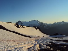
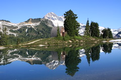
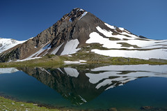
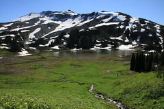
“Three of us started the megahike at 8:30 am from the parking lot near the Blackcomb gondola. At a relaxed pace we reached Russet Lake right before noon and after a short break moved towards Whirlwind Peak. The weather was as epic as our hike with clear blue skies and warm air. 🙂 On the way up we put on crampons and with the help of ice axes ascended via a pocket glacier to the saddle between the Fissile and Whirlwind Peaks. From there we crossed the top of the pocket glacier and ended up on the Whirlwind Peak at 1:50 pm. After a 30 min snack break we started totally gorgeous ridge walking towards Overlord mountain. It is mostly scrambling with small patches of snow closer to the Overlord Mountain. At 3:40 pm we reached our destination and enjoyed late lunch under severe exposure to awesomeness. We took about an hour to will ourselves to leave this beautiful mountain but we found strength and started our way back home. We summitted Whirlwind Peak again but this time we used the eastern ridge to descend from it to the plateau using snow fields for boot skiing down as much as possible. Near the first stream of water coming from the glacier we refilled our water supply using a filter that I brought with me to avoid carrying too much water. We timed perfectly as the sunset found us stepping on a wide Russet Lake trail. After Singing Pass we proceeded through the forest with head lamps. At 11:20 pm we finished the megahike at the parking lot. Due to some minor knee malfunction of one of my companions the descent took almost the same time as the ascent but nevertheless it was unbelievably good day.

This is the soundtrack of our hike: https://www.youtube.com/watch?v=iQ1OV75weYA
For the detailed report see https://www.livetrails.com/report/3508/0/Overlord_Mountain_From_Whistler_Village”

Overlord Mountain 10.09.2011 147

Elfin Lakes 10/09/11

Stuart at Elfin Lakes:
“The Gran Fondo bike event worked in our favour with the exception of an over enthusiastic volunteer who closed off the Sea to Sky Hwy at Horseshoe Bay at 5am instead of 6.30am. After a short detour through Horseshoe Bay and breakfast in Squamish four diehards set of at the trailhead at 6.50am. We had the whole trail to ourselves in the morning and hiked the ridge in the shade as the sun was still low in the sky. We arrived at Elfin Lakes at 9.30am and lucked out as the water was like glass providing amazing reflections of the backdrops. The cabin was fairly empty with just a few hikers who came in the night before. After 1 ½ hours at the Lakes the group decided to take in the Gargoyles as it was still morning and we thought we would be able to get away from the persistent black flies to eat lunch but no such luck. Heading up the Saddle Trail and the additional 6km hike/scramble to the Gargoyles is rewarded with amazing vistas of Columnar Peak, and back towards Elfin Lakes. Watch out for the small blue frozen lake to the North, but even cooler was the hiker at the summit reading a Kindle. We returned to Elfin Lakes for a dip to cool off in the refreshing glacial waters before heading back to the parking lot. Parts of the ridge and Saddle Trails are still covered in snow providing a means to cool off.”

IMG_0725

Harrison Lake 10/09/11

Susie D. checking out lakes near Harrison Hot Springs:
“This turned out to be a stellar idea for a day trip! On a hot sunny day it was great to mix swimming with hiking. We first hiked the Whippoorwill Trail at Harrison Lake. It was somewhat offputting to see all the dead salmon floating in the lake after spawning, but we got used to the idea. We then swam at a little sandy bay away from the main Harrison beach. We shared the bay with an guy with a houseboat named the Pimp, but declined his invitation to join him for an afternoon of partying. After gelatos in Harrison we headed on to Hicks Lake in Sasquatch Provincial Park. What a pretty lake! We hiked a couple of km to the far end, where there was a quiet beach that we only had to share with a couple of other groups – space for all. The water was warm, fantastically clear, and we spent quite a long time in the water. After drying off and hanging out on the beach for a bit it was time to head back to town, with a stop at the organic hazelnut store on the way back. We all returned armed with hazelnut butter. The objective of the day was to have a relaxing day away from the city, and we definitely achieved our objective.”

Musical Bumps 03/09/11

Carollyne on the Musical Bumps:
“Beautiful meadows in bloom, snow fields, a lovely lake, views of glaciers and distant peaks are what we found on this 10 hour day hike. The trail up from Whistler seems a lot easier than the elevation gain would indicate, due to the gradual grade, smooth condition of the trail and the relatively easy creek crossings. Harmony Creek still has no bridge, but the water levels are low enough so it is not difficult to cross. Flute Creek’s bridge is split in the middle and seemed slippery enough that most of us opted to wade across the creek. Louise actually got across with dry boots. The fork in the trail where left goes to Russet Lake and right goes to Musical Bumps appears below the pass, unlike what 103 Hikes indicates. With plenty of time and energy we took the left fork to Russet and were very glad we did. The contrast between the meadows and glaciated rock and snow fields as well as the beautiful lake was fantastic. The hut was very clean and unoccupied, but small enough you could not depend on using it for an overnighter. We had lunch at lakeside following Andrew’s swim. Returning from the lake, we could not find any shortcut trail directly across the pass to the Musical Bumps, so we had to go back to the main fork and hike back up to the bumps. The Oboe “bump”, the first one on the return trip, has the steepest incline, but they all are up and down. There is no water on this return trip until below the last bump, so if you go this way, fill up at the lake. There seem to be some missing signage, so we did not find High Note trail on the return. After the bumps, we took the trail that follows Symphony Lake. This was a bit of a kicker… a fairly steep 3 km back to the Gondola after already hiking at least 24 km. However, it was the only trail we saw that was clearly marked “Gondola” so it seemed like the best choice. We caught the free return gondola down around 8 pm after enjoying the sunset and finished off at Splitz Grill for dinner. The gondola was running unusually late due to the BBQ package at the Roundhouse… normally this would have to be an overnighter or an extremely early start to do in one day.”

20110903-DSC_0073

Mt MacFarlane 03/09/11

Jeremy on Mt MacFarlane:
“Four brave souls ventured out towards Chilliwack Saturday September 3rd to climb Mount MacFarlane. The drive took to the trail head took less than two hours, and was completely paved, except for the last 200 metres. Easy with 2WD. The parking lot was pretty full upon arrival, with both day hikers and overnighters parked there. 1770 metres is a lot to ascend, and the trail gets to the point and starts ascending within the first 150 metres or so of the hike. It took us three hours to get to the first lake, with few stops to rest. About one hour in, there is a sharp right turn in the trail – if you are looking down, it is easy to miss! It’s up and up and up, through lush forest, across one boulder field and crossing one creek. It’s definitely a slog. The trail was mostly dry, with a little bit of muddy sections near the lake.

The first lake is beautiful, with Mount MacFarlane staring at you from the south end of the lake, and a waterfall cascading from the upper lake, down the face of the ridge visible from the lake’s edge. There are a few flat spots for camping at the north end of the lake, which is where we camped, but there were better spots at the south end of the lake, a further 10 minutes down the trail, and then a steep descent to the lake edge.

After passing flasks around the fire for a while, we all slept well, tired from hiking, even though we had only hiked 3 hours. Sunday morning, it was just a one hour hike up to the second lake. The trail is steep in sections, but not difficult technically. It was great to hike without all our camping gear! The upper lake was still 70% frozen. It was another 45 minutes up the snow free ridge to the top of the mountain – this portion involved a tiny bit of scrambling but it was mostly hiking. At the top, the views were incredible. We could even see Mt. Rainier to the south. We hiked back down to the first lake quickly, ate lunch, packed up, swam, and headed back to the car. It’s even more of a slog down – it’s relentless down and down and down. Hiking poles definitely helped! On our way down, we passed some hikers coming up who warned us that 4 out of the 6 cars parked overnight had been broken into. Fortunately, we were one of the two cars that remained intact. The drive back was quick with no traffic. Epsom salts baths were in order to soothe sore legs from the descent.”

Refelction

Panorama Ridge 03/09/11

Stuart on Panorama Ridge:
“It is amazing the difference 9 days makes, most of the alpine flowers in Taylor Meadows have wilted since our last visit. They are however abundant as you head closer towards Panorama Ridge. There is still plenty of snow on the back of the ridge so I would recommend taking hiking poles to assist in the climb. The snow provides a benefit later on as you can bum slide down between the two peaks to avoid the steep descent back down the trail. Just try to stay in the chute created by earlier sliders to avoid the snow speed bumps but be warned it does take a little while before feelings return again. You need to hit the brakes (heels) before passing over the second ridge to control your speed and you probably want to come to a complete stop before deciding to go further as this is the fastest section. The six of us returned via Taylor Meadows 9½ hours later with 1½ hours on top of the ridge. The rest certainly helps recharge the batteries for the return trip. Again, we had perfect weather and amazing views.”

IMG_0510

Coliseum Mtn 03/09/11

Hurrian on Coliseum Mountain:
“Six of us headed up Coliseum on Saturday. After the long walk to Norvan Falls we pushed up the very steep part of the trail. Where it levels off, it was muddier than normal, probably because of the snow runoff. Even on the ridge though, there was very little snow, which is good because the very moderate and low exposure scrambles might have been a bit dodgy if they were snow covered. We made it to the summit in about 3 or so hours and had a nice lunch. Thanks to Gareth, Norbert, Iryna, Julie and Danielle for a great hike in great company.”

Cabin Lake 02/09/11

Keith at Cabin Lake (twice):
“I called out 2 trips to Cabin Lake and both went off really well. The hike is short but steep up to the lake and the water was cool and refreshing! One the first jaunt there were 7 peole and the 2nd there were 5. The first trip had about 84.56% on the Cabin Lake Swimability Index (CLSI) and we hit 100% on the second hike where everybody got in the water – the goal was the swim after all. Thanks everybody for their spontaneity on signing up with short notice on the trips!”

Mt Burwell 28/08/11

Peter A. on Mt Burwell:
“Jeremy and I reached the summit of Mt. Burwell via the steep trail from the Lower Seymour Conservation Area. A great day for hiking, playing in snowfields, and taking pictures.

The trail is punishing on the way up: very few breaks from the steep gradient. Fortunately, it’s a pretty trail through the hemlock, Douglas fir, up rock faces and roots, and easy to follow. There is one tricky spot to be aware of that the guide books don’t mention: finding the trail off of the Seymour Valley Lookout (a huge rocky dome/promontory). When you arrive on top of the Lookout (about 1 – 1.5 hours into the hike), there are few cairns/trail markings to guide you onwards. You don’t need them to walk the 3 minutes on the east side of the flat promontory to its northern end for terrific views (Mount Elsay, Mount Seymour, and Seymour Lake to the east and north east, and Coliseum Mountain and Mt. Burwell to the west). However, once you’ve feasted your eyes, rested, and are ready to move onwards – i.e. back down the promontory and down to a col that separates the promontory from Coliseum Mountain – the lack of cairns/trail markings on top can make it difficult to find the trail. There are two choices: the easiest way is to walk back on the west side of the promontory in the direction of the col until you see some cairn and flagging that will lead you to the trail to the col. The second way is to retrace the way you came up, i.e. back down the east side of the promontory and back on the trail for about 5 minutes. At that point, just beyond the edge of a small clearing, on your right (facing downhill), look for flagging on some trees. This is a branch in the trail that you likely didn’t see on your way up. This trail runs west, skirting along the bottom of the promontory and to the col (it meets up with the trail coming down from the west side of the promontory.

The trail along the col and up to the intersection with the Lyn Valley Coliseum trail had spots of deadfall, mud and boulder fields to contend with, but trail markings were always there to be found with a little patience and a keen eye. And when ascending Burwell from the tarn that lies between it and Coliseum, stay to the left even though it looks like your approaching a forested cliff: the trail goes up a cleft in the rocks and is easy.

We ascended Burwell in 4 hours (a good pace), and, including the 19 km round-trip bike ride from the parking lot to the trail head (a lot of uphill pedalling at the end of the day!), we were on the go for 8.5 hours.”

Salal Creek 27/08/11

Cara at Salal Creek and Athelney Pass:
“One adventerous hiker joined me in exploring this rugged and remote valley. The trailhead is accessed via the Upper Lillooet FSR which is currently active. There is a pumice mine at 48 km and active logging off a spur at 38 km. Take the right fork of the Lillooet FSR at 45.5 km, signed for Garibaldi Pumice Ltd. Before you reach the gate to the pumice mine, take the rather overgrown and nastily waterbarred road on the left. The road is very rough in places and requires high clearance or incredible nerves and driving skills. The trail to the creek is well marked though the entrance/exit is not from the creek side. Now the rock hopping starts. Near west Salal an alternate route through the trees is marked (again hard to see). Another minor detour through the trees exists and is quite steep. The entrance to this was not marked so we sailed past. Yet more rocks brings you to a well marked entrance to the forest section along the east fork of salal. The avalanche chutes saw plenty of action this past winter so the alder has been flattened and quite a few trees downed roots and all. Once out of the trees 5 km remains to the pass. The company currently holding the mining exploration rights to the area have made quite a mess just past the most recent landslide. This area saw a lot of snow over the winter, some of which still covers over the creek past the slide. We walked on the snow and were able to avoid the creek crossings below the glaciers. Once in the pass, another snow accumulation permits crossing to the west side of the creek. The mining company, with the help of the BC govt has removed the oil barrels on the bench to the west of the pass. Not sure about the lone barrel further to the south. This weekend the weather was perfect, the flowers were amazing, and the views were stunning. Ian and I spent the middle day exploring the bench to the west, then packed part way out. The third day we compleated the trek and finished up with a well deserved dinner in Squamish.”