Yearly Archives: 2010

Sigurd Peak 04/05/10

Erez on Sigurd Peak:
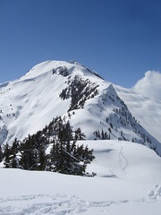
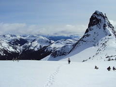
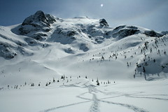
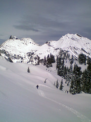
“A bunch of us woke up early and left Vancouver at 6 am for Sigurd Peak near Squamish. We started hiking at 8:30 and the weather was great (blue skies with almost all the peaks around us visible) albeit a pessimistic forecast. The trail is very steep and well-marked until the junction with the trail heading for the creek. Afterwards, the trail markers begin to thin out, and we made our own way towards the ridge. There is quite a lot of fallen trees on the trail especially after the junction. Snow started at 750 m. The snow was quite soft and snowshoes were needed. Two of us also used crampons. We reached the lesser peak (1600 m), from which it is another 300 m climb to the actual peak, at around 14:30 and decided to call it a day after seeing some ominous clouds heading towards us, and being satisfied with the gorgeous view we already see. We made it back to the car at 20:30. On the way back driving the logging road we saw a small black bear. I was in the area last Thursday and saw another (or the same one?) on the trail itself. All in all, it was a great trip with great company.”

DSC02366

Cloudburst 02/05/10

Ahmad on Cloudburst Mountain:
“Doing the same trail exactly on the same day one year before, this I found it less demanding physically but mentally tougher. We parked further up by 2 km than last time which saved good 4 km of logging road hiking which I wasn’t looking forward to do. However, the weather was worse. Once we were on the peak, visibility reduced to zero where I couldn’t see where I was stepping next. It was accompanied by wind and blizzard. Our track to the top was wiped out quickly. We waited for any opportunity of clearing to bypass the cliff section. After a while, our hope for the weather to calm down faded. We decided to negotiate the peak ridge slowly with GPS mainly backed by compass and map as verification. It was quite sketchy.

Snow condition wasn’t bad. There was more snow on the top this time than last year but less at the bottom. we had the entire mountain to ourselves. Pictures and our GPS track are on Live Trails.”

Guanaco Peak 25/04/10

Dan on Guanaco Peak:
“Robert K., Candace, Evgeny, Irina, Chris M., Malin and I headed out amongst clouds and showers on Hwy 1 to the Coquihalla. When we arrived at the Zopkios rest area, the sun came out and we were off to tackle a new snowshoe route to Guanaco Peak.

With 30 cm of fresh snow on top of previous spring accumulations, paceline trail-breaking was employed heading up the Zupjok-Zopkios Ridge saddle. We had great fun sliding into the Coldwater Creek basin, then commencing the long slog through ravines and thick forestations to gain the Vicuna-Guanaco col.

Terrain assessments were continuous and we zigzagged to avoid deep powdery slopes (too taxing to go up) and an avalanche runout zone just before the col. It was nearly seven hours into the hike when Irina, Evgeny and Chris Morley summited.

All the peaks around us have the names of South American ungulates (Zupjok, Llama, Alpaca, Vicuna, Guanaco), and are sometimes referred to as the Llamoid Group. The clean, massive granitic slabs glistening in the sun were breathtaking – majestic even. We took many splendid photos; lingered and drank in the dazzling vista all around us; and refuelled for the long journey back. Five hours later, we were back in our car, exhausted but decidedly happy.

You can see my and Irina’s reports and photos on Livetrails.com”

Guanaco Peak 25.04.2010 216

Mt Mercer 11/04/10

Ahmad on Mt Mercer:
“Our approach was via Foley Creek FSR. It is a logging road but the surface is generally hard with few loose surface sections and postholes. We parked at the intersection of Thurston FSR. Our altitude was 300 m. We discovered later that Thurston FSR was quite drivable for another 3 km especially if the car has high clearance. We also discovered that this FSR goes all the way to the Mercer ridge at 1530 m. The logging road gets less distinct in the last 2 km and it is also open to really nice views to McGuire, Baker, Border, Macfarlane, and Slesse. We opted against bushwhacking and leaving the logging road for the snow conditions and slide risk. It was a hot day and the area had received about 1 m of snow quite recently.

We summitted after about 4:30 hours. The views were excellent. The snow was also king-quality. We stayed for a long while but I had some concerns about the increasing heat and risk of slides so we didn’t stay that long. Total trip took 8:20 hours. I find the peak is underrated and think it is better than the other side of the ridge Elk-Thurston. This trip could be also done with a combination of hiking and biking.

This area seems to be versatile and used by different groups. We met dirt bikers and bear hunters (!) on our way back at lower elevation.

Pictures & GPS track on Live Trails.”

Joffre Lakes 10/04/10

Irina at Joffre Lakes:
“Beautiful winter hike albeit shorter than I expected: took us 1.5 h to get to the upper lake without even trying! Plenty of time to enjoy the views from both sides of the Upper Lake. Saw a group of skiers skinning up towards Tszil; looked temping but we weren’t prepared for travel in the avalanche country. Another group went towards Taylor.

There were several cars in the parking lot when we arrived, and despite abundant snowfall over the past two weeks, the tracks to were deep and well-packed, practically eliminating the need to trail-break. The two lower lakes have started thawing closer to the shore and parts of the trail across the lakes were slushy. With lots of time to spare, we dropped by Nairn Falls on our way back for the view of captivating rock structures eroded by water and finished the day with dinner at the Shady Tree. Thanks to our amazing drivers Cara and Stephen for making this trip happen!

My report with full photo album is on Live Trails.”

Joffre Lakes 10.04.2010 149

Elfin Lakes 03/04/10

Malin at Elfin Lakes:
“The weekend started out with a blizzard, but ended with beautiful sunshine, warm temperatures and magnificent views. Danette, Brandon, Dennis and I left Vancouver early on Saturday morning and headed towards Squamish. The logging road up to the trailhead was in much better condition than three weeks earlier and no chains were needed. There was however lots of snow on the trail. Around lunchtime the sun teased us by letting a bit of light through the heavy clouds, but after lunch in Red Heather Hut the snow was coming down quite heavily and the wind picked up. The hike along Paul Ridge offered no views and we were quite happy to reach the Elfin Lakes shelter in the late afternoon. The shelter was half covered in snow and had to be entered through the balcony door. The first task after having reserved a bunk bed was to dig out the outhouse, which was completely covered. The shelter filled slowly, but by the time we finished supper every bunk bed was filled. The next morning the fog and clouds had all unexpectedly blown away and the Gargoyles and surrounding peaks were clearly visible against a blue sky. This area is so full of surprises and every visit is a new experience. Due to the gloomy hike up the previous day, we took our time and appreciated every minute of our trip back.”

Vantage Peak 27/03/10

Ben on Vantage Peak:
“Dan, Georg, and I left Vancouver early on a quest for fair weather and good snow. The road was clear and we arrived at the trailhead just after 9:00. The route up Cerise Creek was well-packed by skiers and we were able to move quickly. In under two hours we were out of the trees and looking up at the glaciers hanging off the impressive peaks of the Joffre group. We then cut away from the main route and headed for the Vantage-Matier col. The snow was in great condition and we had ski tracks to follow up some of the slopes. Fifteen minutes before we reached the col we were set upon by a thick fog and visibility dropped to just a few metres. On the approach we had scoped out large cornices above and decided not to risk further navigation up the ridge in such conditions. At 1840 m, the col was the high point of our trip. We headed down and spent a couple more hours exploring the valley and checking out the hut. This area is well worth the travel time required.”

Zoa Peak 20/03/10

Ben at Zoa Peak:
“A group of six hikers set out for Zoa Peak just minutes after the spring equinox. The stars were thus nicely aligned to provide us with some great conditions for our trip. The location of the trail proper was a bit elusive, but we passed a couple of helpful folks from Chilliwack that pointed us to the most direct route. We spent less than half an hour in the forest before the views started opening up, and we had a whole wide ridge-top loaded with soft snow on which to tromp around and explore. Thanks to everyone for joining to
make this a trip to remember.”

Zoa Peak Mar. 20, 2010

Mt Laughington 14/03/10

Rob M. on Mt Laughington:
“A late start (late TR as well) and following a “prospector” through a brief 4×4 adventure after the Foley Creek FSR, placed five of us into a parking lot filled with BCMC vehicles. The BCMC skiers went down the lower Airplane Creek road while we switchbacked in snowshoes to the upper road. We stopped every twenty minutes to chat up the tango line of peaks to the north – the usual suspects – Lady, Knight, Baby Munday, Stewart, Still and Welch. Dean was the only person amongst us having spent time on Munday and Stewart, but that’s not the reason why he was our designated canary on the snowbridges. The snow pack was heavy, soft and deep so it took us a couple of hours to cover 4 km. We caught up with the skiers’ tracks at this point and soon ran into all 12 BCMC skiers skinning up an elegant line to the peak. A considerable amount of BCMC/Wanderung shared DNA led to a long exchange and catching up leaving both groups a little short of their objectives. We ended up turning back at the sub-summit. It was a fairweather day here, but one of us had to be back in Vancouver by 5:30 pm where the rain was coming down in sheets.”

C031400_1256_00

Sumas Mtn 13/03/10

Steve on Sumas Mountain:
“Five of us headed out to Abbotsford on what was expected to be a very rainy day. However, the weather held out for all but the first few minutes and the last of the journey. We did the West trail which turned out to to be the right move as the East appears to no longer be usable due to blasting (for what purpose I do not know). Snow was hit at 550 metres but could be walked on all of the way to the top.

For those considering hiking this trail it is listed as a 6.5 hr hike but due to a range in hiking speeds within our group and snow it took us almost 8. Though on paper it seems as if the final destination is the peak with the large radio tower, the two highlights really are the East lookout, and Chadsey Lake. I believe this trip might be best used as a shady Summer trip on a hot day with a swim in the lake, but for views, you can do better by driving a bit further and exploring the many options in Chilliwack.

A good time was had by all.”