Tag Archives: LiveTrails

Cloudburst 02/05/10

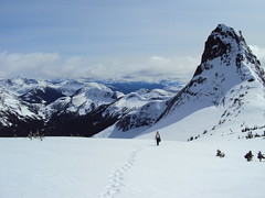
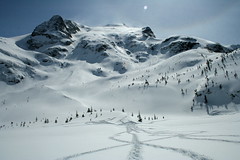
Ahmad on Cloudburst Mountain:
“Doing the same trail exactly on the same day one year before, this I found it less demanding physically but mentally tougher. We parked further up by 2 km than last time which saved good 4 km of logging road hiking which I wasn’t looking forward to do. However, the weather was worse. Once we were on the peak, visibility reduced to zero where I couldn’t see where I was stepping next. It was accompanied by wind and blizzard. Our track to the top was wiped out quickly. We waited for any opportunity of clearing to bypass the cliff section. After a while, our hope for the weather to calm down faded. We decided to negotiate the peak ridge slowly with GPS mainly backed by compass and map as verification. It was quite sketchy.

Snow condition wasn’t bad. There was more snow on the top this time than last year but less at the bottom. we had the entire mountain to ourselves. Pictures and our GPS track are on Live Trails.”

Guanaco Peak 25/04/10

Dan on Guanaco Peak:
“Robert K., Candace, Evgeny, Irina, Chris M., Malin and I headed out amongst clouds and showers on Hwy 1 to the Coquihalla. When we arrived at the Zopkios rest area, the sun came out and we were off to tackle a new snowshoe route to Guanaco Peak.

With 30 cm of fresh snow on top of previous spring accumulations, paceline trail-breaking was employed heading up the Zupjok-Zopkios Ridge saddle. We had great fun sliding into the Coldwater Creek basin, then commencing the long slog through ravines and thick forestations to gain the Vicuna-Guanaco col.

Terrain assessments were continuous and we zigzagged to avoid deep powdery slopes (too taxing to go up) and an avalanche runout zone just before the col. It was nearly seven hours into the hike when Irina, Evgeny and Chris Morley summited.

All the peaks around us have the names of South American ungulates (Zupjok, Llama, Alpaca, Vicuna, Guanaco), and are sometimes referred to as the Llamoid Group. The clean, massive granitic slabs glistening in the sun were breathtaking – majestic even. We took many splendid photos; lingered and drank in the dazzling vista all around us; and refuelled for the long journey back. Five hours later, we were back in our car, exhausted but decidedly happy.

You can see my and Irina’s reports and photos on Livetrails.com”

Guanaco Peak 25.04.2010 216

Mt Mercer 11/04/10

Ahmad on Mt Mercer:
“Our approach was via Foley Creek FSR. It is a logging road but the surface is generally hard with few loose surface sections and postholes. We parked at the intersection of Thurston FSR. Our altitude was 300 m. We discovered later that Thurston FSR was quite drivable for another 3 km especially if the car has high clearance. We also discovered that this FSR goes all the way to the Mercer ridge at 1530 m. The logging road gets less distinct in the last 2 km and it is also open to really nice views to McGuire, Baker, Border, Macfarlane, and Slesse. We opted against bushwhacking and leaving the logging road for the snow conditions and slide risk. It was a hot day and the area had received about 1 m of snow quite recently.

We summitted after about 4:30 hours. The views were excellent. The snow was also king-quality. We stayed for a long while but I had some concerns about the increasing heat and risk of slides so we didn’t stay that long. Total trip took 8:20 hours. I find the peak is underrated and think it is better than the other side of the ridge Elk-Thurston. This trip could be also done with a combination of hiking and biking.

This area seems to be versatile and used by different groups. We met dirt bikers and bear hunters (!) on our way back at lower elevation.

Pictures & GPS track on Live Trails.”

Joffre Lakes 10/04/10

Irina at Joffre Lakes:
“Beautiful winter hike albeit shorter than I expected: took us 1.5 h to get to the upper lake without even trying! Plenty of time to enjoy the views from both sides of the Upper Lake. Saw a group of skiers skinning up towards Tszil; looked temping but we weren’t prepared for travel in the avalanche country. Another group went towards Taylor.

There were several cars in the parking lot when we arrived, and despite abundant snowfall over the past two weeks, the tracks to were deep and well-packed, practically eliminating the need to trail-break. The two lower lakes have started thawing closer to the shore and parts of the trail across the lakes were slushy. With lots of time to spare, we dropped by Nairn Falls on our way back for the view of captivating rock structures eroded by water and finished the day with dinner at the Shady Tree. Thanks to our amazing drivers Cara and Stephen for making this trip happen!

My report with full photo album is on Live Trails.”

Joffre Lakes 10.04.2010 149