Tag Archives: Mt Thurston

Elk-Thurston, 5 Jun 2015

Bob H. on Elk-Thurston:
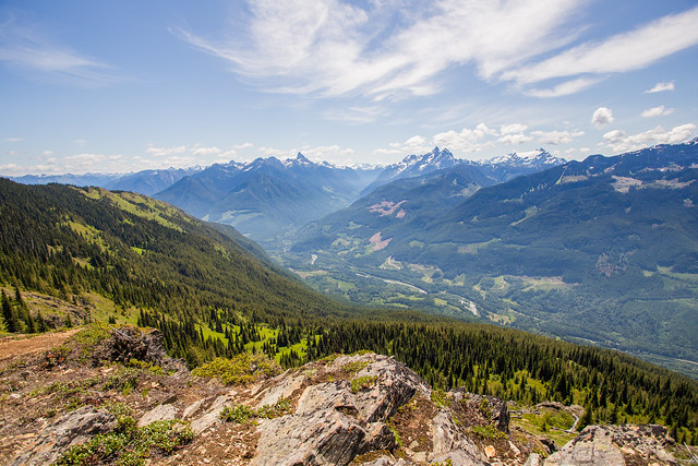
“Back to Chilliwack for another classic hike. Today was the first day of a ‘heat wave’, so I thought it would be good to get out before the temps were supposed to rise on the weekend. It’s also nice to do this hike on Friday and beat the masses. On the way up, our group of 3 only saw one other hiker – a fast pregnant woman! She kicked our butts up there. We would eventually meet more people on the traverse back. There are amazing views of the Fraser Valley, the Chilliwack River Valley, Slesse Creek Valley and many local mountains. Temps were mid 20s in the alpine environment, but dipped to a more refreshing temperature in the forest. As there are long stretches in the sun, we did get plenty of sun. The alpine flowers were in bloom and the colours (red, orange, blue, violet, white, yellow) were amazing. We returned to a hot car and the temperature was high 20s.”

Chilliwack River Valley

Mt Mercer 11/04/10

Ahmad on Mt Mercer:
“Our approach was via Foley Creek FSR. It is a logging road but the surface is generally hard with few loose surface sections and postholes. We parked at the intersection of Thurston FSR. Our altitude was 300 m. We discovered later that Thurston FSR was quite drivable for another 3 km especially if the car has high clearance. We also discovered that this FSR goes all the way to the Mercer ridge at 1530 m. The logging road gets less distinct in the last 2 km and it is also open to really nice views to McGuire, Baker, Border, Macfarlane, and Slesse. We opted against bushwhacking and leaving the logging road for the snow conditions and slide risk. It was a hot day and the area had received about 1 m of snow quite recently.

We summitted after about 4:30 hours. The views were excellent. The snow was also king-quality. We stayed for a long while but I had some concerns about the increasing heat and risk of slides so we didn’t stay that long. Total trip took 8:20 hours. I find the peak is underrated and think it is better than the other side of the ridge Elk-Thurston. This trip could be also done with a combination of hiking and biking.

This area seems to be versatile and used by different groups. We met dirt bikers and bear hunters (!) on our way back at lower elevation.

Pictures & GPS track on Live Trails.”

Elk-Thurston 28/02/10

Ben V. on Elk Mountain:
“Four hikers set out at 10:00 in a medium density fog on yet another unseasonably warm winter day. The trail up to the 1200 m mark was clear without a trace of snow. The last portion to the ridge top was spotted with frozen snow in the forest and slushy snow in the open areas. The ridge top was similar, with snow depth gradually increasing as we progressed. We stopped for lunch at 12:45 on an open bump with a large cairn. There we were rewarded with a few views when the clouds broke briefly and revealed the surrounding peaks that had been hidden all day. We went a bit further to the next highest point to enjoy some of the nice deep snow we were finally upon, and then turned back. We faced some very slippery slopes on way down that added a bit of final adventure to our day.”

Elk-Thurston Feb. 28, 2010