
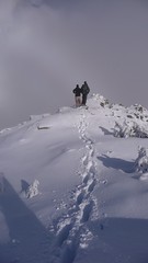
Ahmad on Panorama Ridge:
“Our small group of Ian and I had plenty of luck. The luck of 2 weeks was squeezed into one day. The weather turned clear in the afternoon. The snow was fairly packed. There was a sort of track that we could follow most of the way. So we extended our initial plan and got to the official viewpoint of Panorama Ridge. We estimated the snow to be 0.4-0.5 m in Taylor Meadows, where we started to use snowshoes, and just over 1 m on the Ridge. The snowline started at 1100 m. The park was almost empty except for several students doing their research on the Barrier. Our whole trip took about 10 hours.”
Category Archives: Snowshoe
Mt Harvey 22/11/08
Ribeka on Mt Harvey:
“Incredible day for a crisp November ascent to the peak of Mount Harvey. Ahmad, Tamsyn, Trevor, Aaron and I enjoyed a snowy, steep hike to some beautiful views of Howe Sound and the surrounding peaks. Hit patches of snow right from the start of the Mount Harvey trailhead and ankle deep fluff within the first few hundred metres, right up to the ridge. Enjoyed some incredible sunshine and views for a quick snack stop and orange seed-spitting contest. We continued along the ridge in knee deep snow and scrambled to the top for some more peek-a-boo views of the water below. A foggy lunch and a short rest before slip-sliding our way down. Cedar bark tobagganing, snowball fights and trail flag lawn darts. Good times.”
Rainbow Lake 24/05/08
Darcy at Rainbow Lake:
“Five of us headed up to Whistler for the trail to Rainbow Lake. The first hour of the trail was snow free. We donned snowshoes to travel over a fairly hard packed snow, three to four feet deep. Bob opted to use back country skis with skins. As the trail was hidden and the tree markers often spread out, we veered slightly off course a few times. Ahmad was great at using his compass to navigate, and Eric set us back on course as well, using GPS, his “not lost tool.” There were several “post holes” in the snow where hikers had broken through the upper crust. There were also many snow bridges, thick in some spots and dangerously thin in others. We had to hop across a couple of creeks, and detour higher off trail to find a way over one. There are two large creeks on the trail. We crossed the wood bridge over the first creek, but the platform for the second bridge was still removed for the winter. At this point we had almost reached Rainbow Lake, so we diverted our hike towards Gin and Tonic lake. We took a break with a beautiful view of Rainbow mountain and turned back around 4 pm. The day was sunny blue sky warm and the snow was slushy slippery downhill on the return trip. Constance was happy to see two black bears on our drive home.”
Elfin Lakes 17/05/08
Hurrian P. at Elfin Lakes:
“The four of us set out for Elfin Lakes Saturday morning. Although it was definitely avalanche weather, the winter route to Elfin Lakes was well-planned to ensure little to no exposure to avalanche slopes. The trail definitely required snow shoes. Although there was no snow on the roads, the snow started at the trailhead and, because of the sun, it was slushy with lots of places where a foot just sank in. We saw a few people arrive at the shelter that night without snowshoes and they found the way slow, wet and cold. The sun was hot and a few of us got a little burned. The shelter wasn’t crowded but it was an eclectic bunch there – from the resident five-year-old daredevil, Marcus with his “extreme body sliding” to the elderly Polish man who did multi-day solo treks into avalanche country. It was a great trip.”
Lindsay Lake 11/05/08
Tim at Lindsay Lake:
“Astrid, Dean and Tim set out for Lindsay Lake from Buntzen car park at 9am on Sunday. The snow started at about 800m. At 900m the snowpack was as least 1m deep. Route finding became very difficult once we entered the logged area. Almost all trail markers are still covered above 900m. The logged area is very brushy. GPS and topo map was essential. Also, several sets of old footprints were helpful. The snowpack was very solid and was at least 2m deep at 1000m. Dean hiked the whole day in hiking boots without problem. Tim and Astrid used snowshoes. The lakes are still under deep snow. We made it to Chickadee lake (124666) at around 12:30. Our waypoint for Lindsay Lake (downloaded from Bivouac.com) was wildly inaccurate and we gave up looking for it at around 2pm. We were back at the car park by 5pm. We ran into a trail restoration team from North Shore Hikers on our way back. They have adopted this Halvor Lunden trail and dealing with erosion issues. They mentioned that the famous Halvor Lunden is still going strong and is now 92 years old!”
Navigation course 04/05/08
Mary on Ahmad’s navigation course:
“Anne Marie, Mary, David, Christine, Victor and Jennifer waited for the End Café to open at 9 AM. When our instructor, Ahmad, showed up, we were directed to a private corner with a large window facing Commercial Drive. We all introduced ourselves and explained our needs for understanding navigation better. Anne Marie felt she wanted to be able to navigate through a white out. Mary was unsure about which way to correct for declination.
Introductions over, our teacher spread out an array of topographical maps (for more, see ‘topography’ on Wikipedia). There were many numerals involved, challenging for the math phobics! We examined scales/ratios, elevation intervals/contours, slopes & grades and shading & colour. We tried to envision contour lines as landforms – peaks, cliffs, ridges, gullies and saddles. We all tested our understanding by translating the formations on our Seymour map into a 3 dimensional drawing. Artists we were not!
Next the group produced an assortment of compasses – borrowed, faded housings, brand new, squeaky housing. We learned the nomenclature: orienteering arrow, meridian lines, index line. (Again, look up ‘compass’ in Wikipedia for interesting facts.) Using our instrument we took bearings on various features around us; the trees and posts on the street and even a chair in the café. This was not as easy as it seems. There was a great deal of variations in our measurements, some due metal materials around us affecting the magnetic arrow and some error due to inexperience in holding the compass and sighting.
We followed up by applying our knowledge to the map that Ahmad supplied. Before setting off into the wilds one can make directional notes and then it is quicker and easier to move along. This preparation is useful when there are no amenities outside like a flat working surface or good cover from the elements.
Noon passed and finally we set off for the North Shore. At the park we donned snowshoes and sunglasses. Before moving we took note of Dinky Peak in front of us (a local prominence and aptly named). We progressed slowly, stopping and starting along the trail to Dog Mt. As we were standing around measuring, computing and drawing intersecting lines, we got some attention and gentle ribbing from some day hikers: Lost? Treasure hunting? Finally rest, snacks & socializing with a vista of the lower mainland from our peak. At the saddle below the high point, Ahmad felt his little band were fit and confident enough to head away from the beaten track. We climbed up and followed a ridge to Suicide Bluffs, staying well away from the 45 degree slope. We took bearings at various checkpoints. Our destination was the North Shore Search and Rescue cabin that we had spotted earlier. We did get there using a combination of careful observations of the surrounding features, and following some old snowshoe tracks up a steep slope! Homeward bound, we headed the shortest and easiest route to our cars arriving just after 6 pm.
Good advice for participants – don’t impose any time ceiling on a hike, nature knows no schedules and rushing can defeat the purpose. Great workshop. Thanks Ahmad.”
Mt Seymour 19/04/08
Andy G. on Mt Seymour:
“Rob joined Maria and me on our last-minute snowshoe up Mt Seymour. The weather turned from ideal to perfect, and we were treated to spectacular views all round. The trail was easy to follow, and we reached First Peak just after a beautiful sunset where we were greeted by a bitterly-cold howling gale. A quick group shot and then a hasty retreat. The rising full moon was bright enough that we didn’t need our headlamps on the descent, though the lack of marker poles meant we had to keep a careful eye on the route. (In fact I wouldn’t recommend doing this at night for anyone not familiar with the Mt Seymour trail.) We paused at Brockton Point to admire the city lights before a leisurely return to the parking lot for about 10pm.”
Dam Mountain 12/04/08
Rob at Dam Mountain/Thunderbird Ridge:
“Getting to the mountain chalet was in itself eventful – the Georgia corridor was choked with cars – we took a shorty through Stanley Park where there was a nasty motorcycle accident – to exercise the Good Samaritan vow was exchanged between two onboard who were certified. Midst raucous DJ’s and marketing swag, only the half capacity/half speed blue tram was in operation on the last two skiing days on the mountain. An hour later we were at the chalet in excellent spirits and pumped for the hike. Half an hour into the hike entering the service road we were faced with a number of very active 50 degree+ slopes – lotsa pinwheels but nothing to set off an avalanche – windward slope, no treebombs, cornices, surface evidence of slab instability (we didn’t pit), no human activity at the top. We walked quickly one at a time through anything remotely risky. There were a few inches of fresh snow covering the trail but at least 8 inches of snow was sticky wet making the hike somewhat laborious. We snacked, yaked and hydrated throughout the hike. The trail out onto the ridge seemed safe if you stay the trail. With almost unlimited visibility, the vistas were awesome. Taking advantage of the slippery slopes and our bumpkins we made it back in record time but still missed the last scheduled tram – we hit the parking lot around 11:30. Thanks to Iryna, Nicole and Emily for sharing so much!!”
Elfin Lakes 21/03/08
Michelle at Elfin Lakes:
“Five of us headed to Elfin Lakes on Good Friday with beautiful weather all the way up from Vancouver to Squamish. With all the recent snow, the final portion of the service road had definite winter driving conditions in the morning and required chains – we had to wait for a car with just snow tires to finish “trying” and get themselves safely off the road. Funny observation: all cars parked at the lower pull out lot, us and all the other trucks/4x4s at the upper pull out lot and nothing but jeeps in the actual parking lot.
We were among the early crowd on the trail so it was fairly powdery conditions requiring a little more effort and time (lots of fresh powder up there!). The sun played peek-a-boo all day. We had periods of fine snow mixed with windows of amaaaazing blue sky and sun with great views along the lower trail. However, the view from the ridge was a wall of immovable white. We had beat the throngs to the warming hut but had voted to return early (we only ventured a half hour past the hut up to Paul Ridge), given the hidden view, time and unknown road conditions. We all enjoyed a leisurely return bathed in sun with harder packed conditions from all the traffic now on the trail. Fortunately upon return, road conditions had immensely improved. All in all, beautiful scenery, pleasant weather and great company with a lot of laughs. A great day and the first of many call outs to organize for me I think.”