Leslie on the Baden-Powell trail:
“Eight in total, we were all early for the meeting at Phibbs exchange, even though most didn’t know how to get there. We began at the Lynn Valley Suspension Bridge and made our way to Grouse Mountain. The trail was well marked with the orange triangles signifying the BPT but in some spots short false starts up the wrong trail occurred. The only difficult part was finding where the trail picked up once we walked the 1.1 km of road into Lynn Headwaters Park. It was very well marked but a bit further than originally thought. It was a good hike through mostly second growth forest. I didn’t find the urban infringement too bad, although the viewpoints promised by Dawn Hanna were non-existent. There was that one stream we had to ford using stepping stones, but that just added to the whole experience, which everyone agreed was a great day of hiking!”
Category Archives: Day hike
Mt Gardner 11/05/08
Laurie on Mt Gardner:
“Three of us were optimistic about the weather early this morning and it paid off with great panoramic views of Howe Sound and the Sunshine Coast from atop Mt. Gardner. I’m happy to report that the Mt. Gardner trail is now snow-free! It was the perfect trail to do at this time of year and not busy at all. We ended up doing the loop described in “Easy Hiking Around Vancouver” which was 11km plus the walk to and from the trail head with 655m of elevation gain. We maintained a good pace and made it up in 2 hours, down in 1.5 hours, and were back downtown by 4:30pm. A great day topped off by some great ice cream from the taco stand at the ferry :)”
Lindsay Lake 11/05/08
Tim at Lindsay Lake:
“Astrid, Dean and Tim set out for Lindsay Lake from Buntzen car park at 9am on Sunday. The snow started at about 800m. At 900m the snowpack was as least 1m deep. Route finding became very difficult once we entered the logged area. Almost all trail markers are still covered above 900m. The logged area is very brushy. GPS and topo map was essential. Also, several sets of old footprints were helpful. The snowpack was very solid and was at least 2m deep at 1000m. Dean hiked the whole day in hiking boots without problem. Tim and Astrid used snowshoes. The lakes are still under deep snow. We made it to Chickadee lake (124666) at around 12:30. Our waypoint for Lindsay Lake (downloaded from Bivouac.com) was wildly inaccurate and we gave up looking for it at around 2pm. We were back at the car park by 5pm. We ran into a trail restoration team from North Shore Hikers on our way back. They have adopted this Halvor Lunden trail and dealing with erosion issues. They mentioned that the famous Halvor Lunden is still going strong and is now 92 years old!”
The Chief 11/05/08
Hurrian P. at the Chief:
“This was an organizer’s dream. I had five people who were willing and able to drive. There were no last-minute cancellations, and, best of all, for the first time this year, I was actually able to achieve the objective of a hike. There was no snow anywhere on the Chief. We headed up to the top and had lunch at First peak amongst the chipmunks, who scooted across our hands and legs to show us who was boss up there. The company was great. We discussed how gelato was different from ice cream and then went on an after-hike research trip to determine the answer. (Gelato is made from milk; ice cream is made from cream). Although we had a GP on the trip, we were not able to determine the best first aid procedure for the “head rush” or “brain freeze” that you get from eating ice cream too quickly. More research necessary.”
The Chief 09/05/08
Ruth at the Chief:
“Susan, Neda (1st timer) and I made it up to 1st and 2nd peak at the Chief. Weather was perfect, no snow at all up top, trail was dry and good. Mosquitoes are out though! Total time was 6.5 hours, from beginning of trailhead and back. It was a great day to be out!”

Baden-Powell Trail 04/05/08
Carollyne on the Baden-Powell trail:
“Eight of us enjoyed hiking from Lynn Headwaters to Grouse Mountain. The trail is in good condition, and we shared the trail with a number of friendly mountain bikers in the first half where the trail also has signs for BCMBA. Bikers and hikers accommodated one another well. We somehow missed the first viewpoint described by Dawn Hanna, but found the others, although the fog in Burrard Inlet obscured the views somewhat. MacKay Creek now has a log bridge over it so all the waterways are passable. Mosquito Creek was particularly beautiful. At the end of the trail we saw a number of hikers going up the Grouse Grind although it is still closed. A good trail description/map is essential for this hike due to several odd turns and trail intersections. This section of BPT doesn’t have the wow factor of the first leg from Deep Cove, but was a lot less busy, was very pleasant and was a good transit hike.”
Norvan Falls 03/05/08
Steve at Norvan Falls:
“I was warned by a few people snow would be on this trail and the warnings were right. At the debris chute we had to turn back and I’d have to suggest waiting a few weeks to attempt this again (unbelievable for May!). The 5 of us ended up doing a mostly drizzly hike and wrapping up by noon (right before the sun came out…). By the way, Lynn Headwaters has some great new signs at the trailhead demonstrating the 10 essentials and trail conditions in the area, I’m inspired to do Coliseum this year. And lastly, for such a simple hike (urban meeting spot, short drive, no logging road, moderate difficulty), I personally got quite frustrated organizing this one with the high number of bailouts and lack of solid commitment etc. despite my very clear policy statements.”
Petgill Lake 26/04/08
Hurrian P. at Petgill Lake:
“Despite what was written in the newsletter a couple of weeks ago, Petgill Lake isn’t snow free. The six of us set out, Saturday morning and found as soon as we got to the logging road that there was about two feet of snow in parts. Because of the warm weather the snow was unstable so we found ourselves regularly sinking up to our knees in the snow, resulting in some very cold feet and some unstable footing on the steep parts. I think it still needs about three weeks before the snow will be gone. We decided to turn around about 45 minutes from the Lake and had a lovely lunch on a south aspect rock in the sun. Great weather and great company.”
Baden-Powell Trail 26/04/08
Carollyne on the Baden-Powell trail:
“Six of us enjoyed hiking and conversing from Deep Cove to Lynn Canyon on a perfect sunny day. In about 30 minutes we reached a lovely viewpoint of a paddle race in Deep Cove as well as the surrounding inlet. The trail was in great shape, with quite a few boardwalks and staircases – and well marked. We didn’t find any really good spots for lunch although there are pleasant riverside beaches later on. Twin Falls, various river views and bridges make the occasional backyard views and road crossings only slightly annoying. Doing this as a transit hike from Phibbs Exchange worked very well, although be forewarned that the bus from Lynn Canyon doesn’t run on Sundays. Due to the hillyness of the terrain I would rate is easy-moderate rather than easy. An excellent low-elevation hike.”
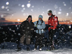
Mt Seymour 19/04/08
Andy G. on Mt Seymour:
“Rob joined Maria and me on our last-minute snowshoe up Mt Seymour. The weather turned from ideal to perfect, and we were treated to spectacular views all round. The trail was easy to follow, and we reached First Peak just after a beautiful sunset where we were greeted by a bitterly-cold howling gale. A quick group shot and then a hasty retreat. The rising full moon was bright enough that we didn’t need our headlamps on the descent, though the lack of marker poles meant we had to keep a careful eye on the route. (In fact I wouldn’t recommend doing this at night for anyone not familiar with the Mt Seymour trail.) We paused at Brockton Point to admire the city lights before a leisurely return to the parking lot for about 10pm.”