
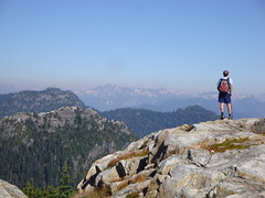
Michelle at the Lions:
“Gone away is the blue bird, here to stay is a new bird. Yep, walking in a winter wonder land. So, there’s like snow up there. We hit some snow on the trail but it wasn’t until the boulder field that the ever increasing blanket of snow and ice presented a challenge. Though negotiable, it made for slow slippery progress and the climb/decent of the ridge connecting with the HSCT proved to be a bit “interesting”. The rocky Lions themselves looked sunbathed and bare and a steady stream of people crawled like a line of ants up and down them. Our climb to the saddle provided gorgeous clear views of the city and entire lower mainland with Baker and the US beyond on one side opposite Howe Sound, the Gulf Islands, HSCT and Sunshine Coast on the other. PS: the crowds of summer evidently haven’t yet cleared on this popular trail. However, the trail itself won’t be clear for long (or at all) as the snow has already started to stick and the daylight is fading fast.”
Category Archives: Day hike
Mt Seymour 27/09/09
Su-Laine on Mt Seymour:
“Beautiful day! Seymour was a lovely hike as always, and almost bug-free. There were plenty of people on the trail but it wasn’t so crowded as to be annoying. Bandidas Taqueria near 12th and Commercial is my new favourite post-hike place (https://www.bandidastaqueria.com/). Good food, and as it’s near the Broadway and Commercial meeting spot, the people who need to go somewhere else don’t have to stay for dinner.”
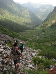
Mt Rexford and Slesse 26/09/09
Michelle at Mt Rexford and Slesse Memorial:
“Chilliwack rarely disappoints – and these two trails exceeded expectations by miles. Chilliwack truly is full of hidden surprises and we were rewarded with larger than life rugged sheer peaks, pocket glaciers and miles of views. The perfect pair – these two trails are literally just a minute down the road from one another and you CAN skip the 4wd (at this time/in dry season this relatively short FSR trek is 2wd to or close to the Slesse Memorial trailhead (thus making BOTH accessible by 2wd with a little paitience – at least in mid summer/early fall). Chilliwack Lake Provincial Park was the perfect overnight accommodation (just down the road) but Riverside Recreation Area would be even better when open during season if not backpacking. It was neat to be able to see where you were going the next day/where you were the previous day (and gave true appreciation for the steep Rex trail hugging the sheer wall beneith Illusion). Slesse Memorial includes a lovely trail, nice gradual climb, a ridge walk, amazing fall colours, jaw dropping setting, plenty of view points and stunning panoramic views from the Propeller Cairn. Rex at 30% average gradient (much more in spots) is not for everyone. But for those up to a non-stop climb, the first half of the trail (after the old road) was a pleasant surprise – a rapid climb but a well formed lovely forest trail. The second half boasted incredible views that just didn’t quit, but it contends with very steep and often loose/unstable terrain. Early starts recommended for both no matter what season – you’ll want the time to fully explore and enjoy the end destinations (which are only the fantabulous enviable beginnings for the climbers).”
Coliseum Mtn 20/09/09
Rob M. on Coliseum Mountain:
“We first laid rubber an a rolling, museum grade asphalt road, biking towards an underrated jewel on the North Shore, Coliseum Mountain. After this idyllic 9 km, a 1 km Dr. Jekyll and Mr. Logging Road change-up ends at an unmarked but obvious trail. The overtaped Christmas Tree look beginning belies the rugged and unrelenting ascent festooned with small root and rock scrambles through new and old growth hemlock. The trail from the 1000 m Paton Lookout takes you down into a small valley then a grind up through a bolder field and the 1441 m summit of Coliseum. The forces of good prevailed after a dramatic struggle between sun and cloud and we were awash in warm light. Lotsa blueberries along the way and hence one bear encounter, who had better things to do than deal with humans. The Coliseum to Burwell (1521 m) hike is a must-do over a large field of smooth open granite for a modest net elevation gain. We met one intrepid hiker travelling incognito with full pack from Cathedral Mountain. The rangers here are kept busy de-taping The Needles to Cathedral Mountain corridor made by renegade hikers. There are a couple of large, deep R&R tarns before stumbling down the slicker-than-heavily-oiled-banana-peel descent. To take us out of our (dis)comfort zone, Eric led us on an off-trail bushwhack around the summit. The bike ride back was a scream! A full 10-hour day.”
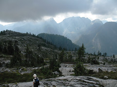
Unnecessary Mountain 01/09/09
Steve on Unnecessary Mountain:
“I didn’t expect such a good response to a mid-week callout. I went with 4 other well matched hikers to Cypress Bowl where we hiked to St. Mark’s Summit, and then on to the dual summits of Mt. Unnecessary. The trail was well marked and easy to follow with 1 minor exception where we got off trail. The weather was variable but we did not get hit with rain. In fact, it was perfect as it kept us cool on the journey, and though it was socked in when we got near the Lions, just as we were leaving, it broke through and offered some moody photo ops.
I really liked this trail, though it was pretty long and the multiple ascents took its toll on my knees. The blueberry factor was phenomenal, and probably added an hour to our trip. One piece of advice I’d offer it to do this as a one way hike and visit the Lions, then descend the Binkert trail. That may actually shave some time, but more importantly allows you to see more peaks on one trip.”
Mt Seymour 30/08/09
Carollyne on Mt Seymour:
“Four of us had a great day on Mt. Seymour. Few cars were in the parking lot when we arrived at 9:45 and the trail up and peaks were quiet – for Seymour on a sunny weekend. There were a few mosquitoes in the shady spots, but no bugs bothered us elsewhere. Haze, perhaps from wildfires, somewhat obscured the views at the top. There was a distinct, if faint, smell of smoke in the air. On the return, the trail was quite busy with people going up. A highlight was watching a black bear feeding on blueberries about 30 minutes up from the parking lot. The trail took 4.5 hours round trip at a fairly leisurely pace plus a very leisurely lunch. We left a now full parking lot and had drinks and appies on Commercial Drive before heading home. Great company made the day even better.”
Mt Bishop 30/08/09
Peter B. on Mt Bishop:
“Three of us biked for one hour along the nice Seymour Valley Trail, waded through Seymour river, climbed up to Mount Bishop for 3 hours (with a 1h stop at Vicar lakes and 1h on the summit) and down for 2 hours and biked back for another hour. The trail is very steep, quite bushy but well-flagged and there is no shortage of ropes. We all liked the upper parts (the lakes and summit) much more than the first 2 hours through the forest. There were many blueberries and blueberry-loaded bear poo. We also saw a bear from a distance (probably eating blueberries or …).”
Radium Lake 29/08/09
Steve at Radium Lake:
“I was warned by a number of people that Radium Lake was more of a hop off point to other great destinations like Mt. Webb or MacDonald. It turns out they were right. Although the trail was pleasant, and extremely well marked, given the elevation gain and distance, it seemed to fly by. The lake itself was unimpressive and there were only peek-a-boo views of the surrounding peaks. However it looked like a great spot for a campsite/basecamp, and many varieties of berries were abundant.
The only potential obstacles on this trail was the numerous bridges, one reported to be out. I’ve seen bridges in far worse condition than this one though I could see where the “break” was. In our case, there was no problem crossing the bridge OR just crossing the stream below. I’m unsure why no one has repaired the bridge, it looks like an easy fix.
Good company though, minimal bugs, and this time we avoided that pub and opted for pizza instead afterwards. Next time, I plan for an overnighter at this destination and intend to check our the surrounding peaks.”
Hanes Valley 23/08/09
Andy in Hanes Valley:
“This has been on my to-do list for some time so it was great to collect a group of six and see the valley up close. We began in Lynn Headwaters and ended on Grouse Mountain. Beyond Norvan Falls (where the creek was just a trickle) the forest soon changed from devastated second growth to a much nicer unlogged forest, complete with some fabulous bright orange fungi. Crossing Lynn Creek was easy on the biggest logjam I’ve ever seen. We broke out of the trees at the helipad where we stopped for lunch before making our way up through the boulder field. The sheer cliffs of Goat and Crown Mountain were quite spectacular and the open nature of the boulder field made for rewarding rest stops with views back to Coliseum and Burwell. We contemplated tackling one of the nearby summits, but unfortunately (or fortunately depending on your point of view), the clouds hung around the summits of Goat and Crown mountains which dissuaded us from adding more elevation gain. So up the muck-and-chains bit we went to join the Goat Mountain trail, and were back at the gondola less than an hour later, pausing only to sample a few of the local berries. To our surprise we had no more than a 10-minute wait for the gondola ride down. The trip took 7 hours end to end. A great day out – thanks everyone!”
Mt McGuire 23/08/09
Su-Laine on Mt McGuire:
“New hiking objective for 2010: finish Mount McGuire. We didn’t make it to the top, but the northwest ridge approach that people have been discussing on Clubtread this year is definitely doable as a day hike from Vancouver. It’s a beautiful area.
Getting to the trailhead from King George station in Surrey took an uneventful 2 hours via the Tamihi Creek FSR. There are reports of locked gates and fallen trees on the road, but we didn’t see any. We were in an SUV and the only other vehicle in the parking area was a Delica. Wide trucks might not be able to get past a couple of rocks on the road. The road is better than the one to Cheam, but I doubt 2WD vehicles could make it up there.
In a routefinding error out of the “don’t ask how we managed to screw that one up” department, we climbed the rockslide on the left rather than the right near the beginning of the hike, in spite of the printed instructions we were carrying and some flagging tape. After 45 minutes of some of the toughest scrambling I’ve ever done, we figured out that it was wrong and downclimbed. The rest of the hike was straightforward by comparison, but there were a few scrambles up steep slopes, and we spent quite a bit of time figuring out where the trail and turning points were. The route mostly follows a mountain goat trail, and is very obvious in some places but not others.
I was wearing a helmet, long pants/sleeves, and bicycle gloves and was glad to have all of them, especially gloves because the rocks that you have to scramble over feel like sandpaper.
We reached a meadow in which you descend into a valley before going up to the summit. Views were good from there and we realized that we weren’t going to be able to get anywhere more interesting by our turnaround time, so we relaxed and feasted on wild blueberries before exploring the ridge a bit more and heading back. It was a very fun day, and we’re all more experienced navigators now. I’d be happy to go back.”