
Michelle in Cheakamus Canyon:
“Green mountains and spandex-clad road cyclists cruising down the Sea to Sky, you know – just your typical winter scenery. The only signs of the impending WINTER Olympics were the Olympic Lane signs starting one block East of Kootenay Loop on Hastings St (FYI – may be a tad trickier than anticipated using this meet spot during the games), sign boards blinking about upcoming road restrictions and the two million metal pole lane dividers hiltied into the asphalt at every single set of curves in the road (basically the whole thing). Traffic was light, but lanes are narrow, and driving wasn’t super speedy. Neither was the hiking – we just ambled along the easy trail happily taking pictures all the while. An enjoyable spring like outing whose only hint of winter was the frosty wind that occasionally blasted through the canyon.”
Category Archives: Day hike
Sunshine Coast 29/01/10
Christian at Roberts Creek and Porpoise Bay Park on the sunshine coast:
“A group of 4 adventurers arrived in Roberts Creek after dark. The roads were very dark and the signs were hard to read. Yet we still found the co-housing commons building on Emery Road. We attended the tail end of a show with the Tetrahedron Outdoor Club. The club members in general were much older and more guarded than we expected. Recreation areas in Tetrahedron Park seem to be a secret, closely guarded from the ears and eyes of us “Townsies”. John, from Surrey, was the social adventurer who started a conversation with smiling Marge. An ever smiling and wise old lady with a fantastic humour. She was very helpful in giving us directions and introduced us to a few club members. After informing others of our intentions, the worry-some looks on club member faces encouraged us to come up with a plan “B”. The road up to Mt Richardson is about as daring as the access road to Tetrahedron Park. There are a few ditches to cross that really require the use of a 4WD. Though, most of the roads are clear of snow this January, the roads are in the transition zone of freezing and are icy. A talkative man named Steve, surprisingly younger than us, gave us tons of advice and even drew up directions. He said going to Tetrahedron requires the use of crampons to walk through the transition area, and then thereafter with snow shoes – glorious powdered snow awaits. A shame that our upcoming Cypress 2010 Olympic events were not held there. 😛
Late in the night, we ventured for a nearby camping spot. We guerrilla camped at Roberts Creek picnic grounds. It was lightly raining all night, and we made good use of three tarps. With the two tents, we stayed really dry and slept well past sunrise. The ocean, the birds, the rain drops and the waves were relaxing for all of us. In the morning, the occasional dog walker made for some interesting doggie entertainment. We were paired up, so we got up at different times. As pairs, we walked along the stone & gravel beach for quite a ways. The stone beaches were quite pleasant and relaxing. Every community member we encountered was friendly and talkative. What a place to live! We returned, we packed up, and we made tea. With everything back in the car, we went to a Roberts Creek cafe – the Gem Top.
At the Gem, we had hot choco, cappuccino, cinnamon buns and gluten free treats. By half past noon, we left the cafe in search of easy walking trails on the logging roads nearby. Following the directions provided by Steve’s hand drawn map was a challenge. We encountered active logging on our preferred road on Saturday, so we turned back and took some other turns. We took a side road and passed what some could call a hippie camp. There from the car, we saw a large green camperized school bus, a teepee and a large yurt built upon on a giant wood deck.
A short drive up further, we stopped at a trail heading up into the bush – between the clear cuts. We followed the trail for 15 minutes until it grew over with dead-fall and disappeared. Instead of turning back, we followed an idyllic stream marked with surveyors tape for another hour. The stream seemed to be marked with tape to help maintain a buffer zone for the loggers. It was an interesting hike along the stream, around trees, deadfall, giant stumps and around natural obstacles. When we came out, we discovered we were hiking up a stream that belonged to the fabled long tailed frog.
By late afternoon, a few were still eager for more hiking and exploration, so we headed over to Porpoise Bay campsite. It was quite a large campsite with many large group shelters. We stopped at the sandy beach and had an early dinner of roast beef and Tsatziki on a picnic table. Post dinner we walked along the trail to Anglers creek and heard a few animals drop or jump into into the fresh water creek as we approached. We envisioned returning to Porpoise Bay in the summer for glorious swimming at the sandy salt water beach and for other play in the calm & deep fresh waters of Anglers Creek. We were tempted to jump in right there into the crystal waters of the creek, yet we held off and returned to Vancouver happy and dry.”
Mt Harvey 12/11/09
Erez on Mt Harvey:
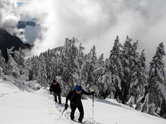
“On Thursday, four of us: Dan, Dorothy, Rob, and myself, headed to Lions Bay to climb Mt. Harvey. It was a little cloudy in the morning, but the weather improved considerably. Snow started at around 870 m and the snow was knee-deep at around 1100 m, and more than hip-deep near the top. When we reached the ridge, clouds began to cover Howe Sound. The Lions, however, were not covered. As we continued it got even cloudier. Only two of us had snowshoes, and so the other two (me included) decided to turn back and not reach the top as it didn’t seem that the view would be better there. There was a ton of snow up there, way more than I expected. All of us reached the car at around 16:30, after about 7 hours of hiking. I hope to return to Harvey, when it’s not so cloudy. It was a very nice hike with nice company.”
The Chief 01/11/09
Ahmad on the Chief:
“Almost no people when we started at 10 am. It was the first time I’ve seen the Chief that empty especially on a nice day like today. Not much of a difference than it was one month ago except things seemed wetter and colder. The scramble is easy with ropes and all of us managed without a problem. The last one is difficult but the rope makes it easy. We went up also on the second peak and descended via the main trail. Dogs cannot get over the chained-steep section. We saw few dogs got stuck there. This trail is not obvious. It branches off in several places. It took us 6 hours at a luxury pace.”
Zoa Peak 24/10/09
Christian on Zoa Peak:
“Crunch, crunch, crunch – a great Coquihalla social.
Five of us started out from Surrey, and arrived at the trail head above the Coquihalla Summit in good order. Everyone was well prepared. As soon as we started hiking from the “Falls Lake” right of way, we encountered a fresh dusting of snow. Mount Thar, beside Falls Lake, all covered in snow, looked awesome! Crunch, crunch, crunch – we could hear almost every step in the inch of snow all the way to the top. It was so quiet, nothing could be heard when we stopped moving. A true winter wonderland! Along the trail, we saw fresh footprints of squirrel, rabbit, grouse, fox and wolf. However, there was no sign of the elusive “snow snug”. 🙂 Shucks! Clouds rolled though as we reached the summit. Views kept coming and going. We were envious of the sun drenched hills right across the valley to the North. The summit wasn’t a true peak. Our views to the West were obscured. We settled in at the summit, and started cooking. Ah, lunch! We began with a sweet egg pasta curry with fresh tomato and carrot, cooked up a spiced brown rice with honey glazed beef, and had a light cous-cous dabbled with mango and pineapple. We finished off the meal with green tea and yogurt covered raisins. Fantastic! We had conversations about careers, travel, and cultural comparisons. The two architects on the trip, had lots to say! Allan cracked jokes all day. Mighty Zoltan took many pictures – a true Flickr aficionado! Our return down was quick, and full of conversation. We drove down the highway to Hope and arrived at the Home Restaurant before dark. We all ate from massive plates of great food. On the plates, the piles were so big, yam fries were falling off onto the table. We learned the new term: “Mountain money.” And we discovered the value of Gore-Tex socks. This product keeps feet dry regardless of how wet footwear becomes. An awesome product for West Coast hiking.”

Lindsay Lake 11/10/09
Alain at Lindsay Lake:
“On Sunday October 11th, I was joined by Allan, Chad, Cindy, Debra, Lyndon, Rob, and Robin on this very rewarding hike. We left the trailhead at Buntzen Lake just before 10:00 am. The trail ascended at a moderately steep pitch for the next couple hours before we came to a plateau upon which we passed by several small lakes, one of which had a thin sheet of ice covering it. We continued upon the plateau for approximately one hour before reaching Lindsay Lake which was very pretty and our lunch stop. We decided to make the ascent to Tangled Summit (Mount Beautiful) rather than complete the Lindsay Lake loop. The trail between Lindsay Lake and Tangled Summit does lose a fair bit of altitude before making a final steep ascent to the summit. We had been worried that we somehow ended up on the wrong trail and were headed down the mountain, but alas we were on the right path and approximately an hour and a half after leaving Lindsay Lake, we made the summit. We could not have been better rewarded with the spectacular panoramic view in clear sunny skies. We could easily see downtown Vancouver and further west to the Island, Indian Arm and across it to Deep Cove, and to the east, Coquitlam Lake just below, and further to Mount Baker. It was difficult to pry ourselves from our sunny perch, but finally we began to descend using the Swan Falls trail. While a much steeper trail than the one we ascended with, it still took about 2 1/2 hours for most of our group to reach the base of the trail at the far (North) end of Buntzen Lake which still left a 4.5 km hike along a service road to our cars. As both darkness and the closing time of the park gate were nearly upon us, one member of the group was forced to run the entire length of the 4.5 km service road in just half an hours time (with sore tired legs I might add) to flag down a BC Hydro Park attendant who agreed to pick up 6 members of our group who were at various sections of the service road, and they then enjoyed a relaxing ride back to the parking lot in the back of a pickup truck. Notwithstanding the little crisis near the end of the hike, all in all there was great satisfaction all around. Recommend allowing 10 hours if combining the Tangled Summit and Lindsay Lake hikes as we did.”
Eagle Bluffs 10/10/09
Su-Laine on Eagle Bluffs:
“Holy, is the summit of Black Mountain ever a good place for a nap. Six of us were treated to a day of ideal conditions for hiking up the Baden Powell trail from the highway to Eagle Bluffs. No snow, no ice, and minimal mud were encountered. We liked it so much that we continued the 45 minute trip to the top for the aforementioned siesta amongst the mountaintops and Howe Sound views.”
First Brigade Trail 10/09/09
Steve on the First Brigade Trail:
“Fall is the time to do this hike. Notorious for ticks in the Summer, and with the Fall foliage, best to stick to alpine areas and reserve this for when the snow levels encroach. Whether I was out of shape or the stats were off, for some reason it seemed higher and steeper than I expected. In fact, I was questioning the popularity of this trail until we hit the forest fire remnants. This was what makes this hike unique – the open area in the midst of the former burn and foliage that is sprouting up as a result. To our surprise, where this trail meets the 1858 Trail (to Gate Mountain), there was an outhouse and picnic table! What else was really unique about this hike is that it is a loop of sorts allowing you to walk one ridge on the way out, and a different ridge on the way back (the lower half is common though). Views themselves on this trail are unique, but mediocre. We hit no snow, but there was evidence it was coming, What we did see a lot of was blowdown near the higher elevations, but it was easily stepped over and looks as if some recent cleanup efforts had been made. We went for “I Fly for Pie” for post-hike eats”
Mt Strachan 04/10/09
Su-Laine on Mt Strachan:
“Strachan was a delightful place to spend one of those you-have-to-get-out-there beautiful fall days. We took the advice of a fellow Wanderunger and went counterclockwise, which had the benefit of putting the more-slippery part of the trail on the uphill. We encountered about 4 cm of snow about halfway up but besides the occasional slippery rock it wasn’t a problem to walk on. As a variation on the usual route, we had lunch on the non-crowded south summit, then hiked back to the saddle and up to the north summit to take a look, and then back to the south summit to continue our counterclockwise route. Then on the way back down we cut over to the ski run which saved some time. It worked out quite nicely, giving us lots of time to take in the magnificent views at the top and the blueberries on the way down.”
Brew Lake 04/10/09
Steve at Brew Lake:
“Despite many warnings of poor markings, we found this trail to be relatively easy to navigate (we assume recent markers were added, plus we had Club Tread GPS waypoints). On a great day for a Fall hike five of us traversed scree slopes and pine needle trails.
This trail marks my memory most with three images: a great view of Black Tusk, the scenic bowl containing the lake itself, and the rather unique first few km walking on train tracks.
I was not feeling 100% this day so a big thanks to my hiking companions and their patience, which kept the group together. Despite dragging my ass up there, we still managed to get back in almost exactly what 103 Hikes suggested: 7 hours. We did see a hint of a trace of snow, but had to walk on none.”