
Carollyne on the Baden-Powell trail:
“Six of us enjoyed hiking and conversing from Deep Cove to Lynn Canyon on a perfect sunny day. In about 30 minutes we reached a lovely viewpoint of a paddle race in Deep Cove as well as the surrounding inlet. The trail was in great shape, with quite a few boardwalks and staircases – and well marked. We didn’t find any really good spots for lunch although there are pleasant riverside beaches later on. Twin Falls, various river views and bridges make the occasional backyard views and road crossings only slightly annoying. Doing this as a transit hike from Phibbs Exchange worked very well, although be forewarned that the bus from Lynn Canyon doesn’t run on Sundays. Due to the hillyness of the terrain I would rate is easy-moderate rather than easy. An excellent low-elevation hike.”
All posts by andy
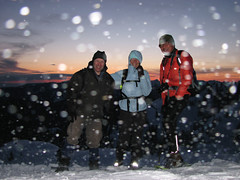
Mt Seymour 19/04/08
Andy G. on Mt Seymour:
“Rob joined Maria and me on our last-minute snowshoe up Mt Seymour. The weather turned from ideal to perfect, and we were treated to spectacular views all round. The trail was easy to follow, and we reached First Peak just after a beautiful sunset where we were greeted by a bitterly-cold howling gale. A quick group shot and then a hasty retreat. The rising full moon was bright enough that we didn’t need our headlamps on the descent, though the lack of marker poles meant we had to keep a careful eye on the route. (In fact I wouldn’t recommend doing this at night for anyone not familiar with the Mt Seymour trail.) We paused at Brockton Point to admire the city lights before a leisurely return to the parking lot for about 10pm.”
Lynn Peak 12/04/08
Hurrian P. at Lynn Peak:
“Despite an organizer (who shall remain nameless) who got on the wrong bus and arrived twenty minutes late for the meeting time, this hike went very well. The warm weather at the bottom made it seem very unlikely that there would be much snow up top. But after an hour or so of climbing the trail was covered in snow. Soon the snow was about 6 feet deep and the trail became narrower and narrower until it was just a series of footprints sinking three feet in the snow. About 3/4 of the way up, the footprint trail split apart and it became difficult to determine which was the real trail. There weren’t many markers visible as they must have mostly been buried. We decided to turn around and head back down after having lunch at a partial lookout.”
Dam Mountain 12/04/08
Rob at Dam Mountain/Thunderbird Ridge:
“Getting to the mountain chalet was in itself eventful – the Georgia corridor was choked with cars – we took a shorty through Stanley Park where there was a nasty motorcycle accident – to exercise the Good Samaritan vow was exchanged between two onboard who were certified. Midst raucous DJ’s and marketing swag, only the half capacity/half speed blue tram was in operation on the last two skiing days on the mountain. An hour later we were at the chalet in excellent spirits and pumped for the hike. Half an hour into the hike entering the service road we were faced with a number of very active 50 degree+ slopes – lotsa pinwheels but nothing to set off an avalanche – windward slope, no treebombs, cornices, surface evidence of slab instability (we didn’t pit), no human activity at the top. We walked quickly one at a time through anything remotely risky. There were a few inches of fresh snow covering the trail but at least 8 inches of snow was sticky wet making the hike somewhat laborious. We snacked, yaked and hydrated throughout the hike. The trail out onto the ridge seemed safe if you stay the trail. With almost unlimited visibility, the vistas were awesome. Taking advantage of the slippery slopes and our bumpkins we made it back in record time but still missed the last scheduled tram – we hit the parking lot around 11:30. Thanks to Iryna, Nicole and Emily for sharing so much!!”
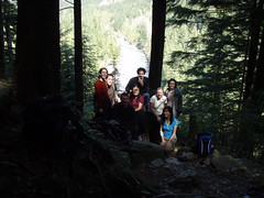
West Canyon Trail 12/04/08
Melanie at Golden Ears Park, West Canyon Trail:
“On a gorgeous day, 8 of us hiked part of the West Canyon trail to the lower falls viewpoint and the Gold Creek lookout which gave a partially obscured view of the valley below. There was no snow and also no parking meters. Five of us decided to continue by taking the viewpoint trail. Thanks to everyone for the great company and entertaining conversation (and delicious Girl Guide cookies)!”
Polytrichum Lookout 04/04/08
Ruth at Polytrichum Lookout:
“Just a quick report of a little hike up to Polytrichum Lookout April 4th. Joshua, Ying, Ranger (my dog) and I had a good workout up to Polytrichum. It was pouring rain in Surrey when we left, and rained a bit on the way up, but we didn’t mind one bit. Took about an hour to get up from the parking lot. Was their first time with Wanderung, so welcome and hope to see you out on more hikes soon! 🙂 Recommend this as an alternative to the Grind. Way less people, and closer to home if you live in Surrey or the Coquitlam area.”
Note: Polytrichum Lookout is on the way up to Lindsay Lake
Lindsay Lake 30/03/08
Hurrian P. at Lindsay Lake:
"Like most great trips, this one didn’t really go as planned, but the day’s adventure made it worthwhile. As we started to ascend up from Buntzen Lake I doubted that we needed snowshoes but by the time we got to the ridge there was 8 feet of snow. We followed the tracks of some errant snowshoers and somehow wandered off the regular trail to some place to the east of Eagle Peak. Luckily we bumped into a mysterious older man named Bob who looked like he had stopped aging a decade or so back. He confirmed that we were nowhere near the Lindsay Lake trail. (All of the signposts were buried.) He said we could find the proper trail again but we’d have to bushwhack through the forest among very deep tree wells to get there. He led us past Cypress Lake and to a great lookout over the eastern Lower Mainland before depositing us back at the proper trail. I think the trip demonstrated the need to also bring a topographical map because 103 Hikes, however good, does not provide sufficiently detailed maps."
West Canyon Trail 29/03/08
Ahmad at the West Canyon & Viking Trails:
“The roads were fine and accessible to the parking lots. There was also no parking meters so the parking was free this time. The Viking trail had a shallow layer of snow while West Canyon had some scattered snow patches. We met few people on the trail. The waterfalls were not in their full capacity yet. Thanks to Melanie who warned me about the road conditions.”
Baden-Powell Trail 29/03/08
Melanie on the Baden-Powell trail:
“On a fabulously sunny day, five of us hiked the first part of the Baden Powell trail from Deep Cove to Lynn Canyon. There were views of Deep Cove at the rock, some nice forested sections, a canyon, waterfalls, and a bit of a steep grind at the end to work out the leg muscles. Great company and conversation. Reminisced about the newly renovated suspension bridge and its lost Indiana Jones style thrill appeal. Finished a fantastic day with donuts at the famous Honey’s.”
Mt Gardner 22/03/08
Hurrian P. on Mt Gardner:
“With a little help from an SFU/UBC hiking group named, not-so-creatively, “Hiking Group”, the five of us were able to find the trail head to Mount Gardner. The path was quite tricky to find at times and there were crossroads without clear markings. Only the top few hundred metres was snow-covered but it was quite slippery on the north slope, especially the final steep section. On the way back, we decided to take the alternative route and followed a very sparse trail back to Snug Cove – often the only way that we could tell that there was a trail were the signs that some very adventurous soul had decided to mountain bike that route down from Mount Gardner. Our conversations, although diverse, intellectual and entertaining always found their way back to Wikipedia sex scandals – ask Su-Laine.”