Brenda kayaking at Prevost Island:
“Daphne, Mazie, Michael and I spent 3 beautiful days kayaking Prevost Island (launching point was Mayne Island). This is easily accessible area that is well worth a weekend trip. We were able to take the bus from Vancouver to catch the Gulf Islands Ferry then Mayne Island Kayak rentals picked us up from the terminal. Unfortunately, Mazie learned the hard way to not make it just in time for the ferry. The bus she planned to take was full and drove right by her. She was still able to make it to Tsawwassen in time but they were not taking any more passengers onto the ferry. She ended up taking a ferry to Schwartz Bay then to Ganges; rented a kayak there then paddled on her own to Prevost Island where she met up with us. That is what I call determination! We spent the second day kayaking around Prevost Island; at times paddling against wind and currents and other times relaxing while the current did the work for us. Prevost was a beautiful island to spend 2 nights although there were a lot of people there on the long weekend. Mayne Island Kayak was a great company to rent from. They were very helpful but we did find the shuttle fee of $10 per person per direction a little steep!”
All posts by andy
Mt Gardner 11/05/08
Laurie on Mt Gardner:
“Three of us were optimistic about the weather early this morning and it paid off with great panoramic views of Howe Sound and the Sunshine Coast from atop Mt. Gardner. I’m happy to report that the Mt. Gardner trail is now snow-free! It was the perfect trail to do at this time of year and not busy at all. We ended up doing the loop described in “Easy Hiking Around Vancouver” which was 11km plus the walk to and from the trail head with 655m of elevation gain. We maintained a good pace and made it up in 2 hours, down in 1.5 hours, and were back downtown by 4:30pm. A great day topped off by some great ice cream from the taco stand at the ferry :)”
Lindsay Lake 11/05/08
Tim at Lindsay Lake:
“Astrid, Dean and Tim set out for Lindsay Lake from Buntzen car park at 9am on Sunday. The snow started at about 800m. At 900m the snowpack was as least 1m deep. Route finding became very difficult once we entered the logged area. Almost all trail markers are still covered above 900m. The logged area is very brushy. GPS and topo map was essential. Also, several sets of old footprints were helpful. The snowpack was very solid and was at least 2m deep at 1000m. Dean hiked the whole day in hiking boots without problem. Tim and Astrid used snowshoes. The lakes are still under deep snow. We made it to Chickadee lake (124666) at around 12:30. Our waypoint for Lindsay Lake (downloaded from Bivouac.com) was wildly inaccurate and we gave up looking for it at around 2pm. We were back at the car park by 5pm. We ran into a trail restoration team from North Shore Hikers on our way back. They have adopted this Halvor Lunden trail and dealing with erosion issues. They mentioned that the famous Halvor Lunden is still going strong and is now 92 years old!”
The Chief 11/05/08
Hurrian P. at the Chief:
“This was an organizer’s dream. I had five people who were willing and able to drive. There were no last-minute cancellations, and, best of all, for the first time this year, I was actually able to achieve the objective of a hike. There was no snow anywhere on the Chief. We headed up to the top and had lunch at First peak amongst the chipmunks, who scooted across our hands and legs to show us who was boss up there. The company was great. We discussed how gelato was different from ice cream and then went on an after-hike research trip to determine the answer. (Gelato is made from milk; ice cream is made from cream). Although we had a GP on the trip, we were not able to determine the best first aid procedure for the “head rush” or “brain freeze” that you get from eating ice cream too quickly. More research necessary.”
The Chief 09/05/08
Ruth at the Chief:
“Susan, Neda (1st timer) and I made it up to 1st and 2nd peak at the Chief. Weather was perfect, no snow at all up top, trail was dry and good. Mosquitoes are out though! Total time was 6.5 hours, from beginning of trailhead and back. It was a great day to be out!”

Baden-Powell Trail 04/05/08
Carollyne on the Baden-Powell trail:
“Eight of us enjoyed hiking from Lynn Headwaters to Grouse Mountain. The trail is in good condition, and we shared the trail with a number of friendly mountain bikers in the first half where the trail also has signs for BCMBA. Bikers and hikers accommodated one another well. We somehow missed the first viewpoint described by Dawn Hanna, but found the others, although the fog in Burrard Inlet obscured the views somewhat. MacKay Creek now has a log bridge over it so all the waterways are passable. Mosquito Creek was particularly beautiful. At the end of the trail we saw a number of hikers going up the Grouse Grind although it is still closed. A good trail description/map is essential for this hike due to several odd turns and trail intersections. This section of BPT doesn’t have the wow factor of the first leg from Deep Cove, but was a lot less busy, was very pleasant and was a good transit hike.”
Navigation course 04/05/08
Mary on Ahmad’s navigation course:
“Anne Marie, Mary, David, Christine, Victor and Jennifer waited for the End Café to open at 9 AM. When our instructor, Ahmad, showed up, we were directed to a private corner with a large window facing Commercial Drive. We all introduced ourselves and explained our needs for understanding navigation better. Anne Marie felt she wanted to be able to navigate through a white out. Mary was unsure about which way to correct for declination.
Introductions over, our teacher spread out an array of topographical maps (for more, see ‘topography’ on Wikipedia). There were many numerals involved, challenging for the math phobics! We examined scales/ratios, elevation intervals/contours, slopes & grades and shading & colour. We tried to envision contour lines as landforms – peaks, cliffs, ridges, gullies and saddles. We all tested our understanding by translating the formations on our Seymour map into a 3 dimensional drawing. Artists we were not!
Next the group produced an assortment of compasses – borrowed, faded housings, brand new, squeaky housing. We learned the nomenclature: orienteering arrow, meridian lines, index line. (Again, look up ‘compass’ in Wikipedia for interesting facts.) Using our instrument we took bearings on various features around us; the trees and posts on the street and even a chair in the café. This was not as easy as it seems. There was a great deal of variations in our measurements, some due metal materials around us affecting the magnetic arrow and some error due to inexperience in holding the compass and sighting.
We followed up by applying our knowledge to the map that Ahmad supplied. Before setting off into the wilds one can make directional notes and then it is quicker and easier to move along. This preparation is useful when there are no amenities outside like a flat working surface or good cover from the elements.
Noon passed and finally we set off for the North Shore. At the park we donned snowshoes and sunglasses. Before moving we took note of Dinky Peak in front of us (a local prominence and aptly named). We progressed slowly, stopping and starting along the trail to Dog Mt. As we were standing around measuring, computing and drawing intersecting lines, we got some attention and gentle ribbing from some day hikers: Lost? Treasure hunting? Finally rest, snacks & socializing with a vista of the lower mainland from our peak. At the saddle below the high point, Ahmad felt his little band were fit and confident enough to head away from the beaten track. We climbed up and followed a ridge to Suicide Bluffs, staying well away from the 45 degree slope. We took bearings at various checkpoints. Our destination was the North Shore Search and Rescue cabin that we had spotted earlier. We did get there using a combination of careful observations of the surrounding features, and following some old snowshoe tracks up a steep slope! Homeward bound, we headed the shortest and easiest route to our cars arriving just after 6 pm.
Good advice for participants – don’t impose any time ceiling on a hike, nature knows no schedules and rushing can defeat the purpose. Great workshop. Thanks Ahmad.”
Norvan Falls 03/05/08
Steve at Norvan Falls:
“I was warned by a few people snow would be on this trail and the warnings were right. At the debris chute we had to turn back and I’d have to suggest waiting a few weeks to attempt this again (unbelievable for May!). The 5 of us ended up doing a mostly drizzly hike and wrapping up by noon (right before the sun came out…). By the way, Lynn Headwaters has some great new signs at the trailhead demonstrating the 10 essentials and trail conditions in the area, I’m inspired to do Coliseum this year. And lastly, for such a simple hike (urban meeting spot, short drive, no logging road, moderate difficulty), I personally got quite frustrated organizing this one with the high number of bailouts and lack of solid commitment etc. despite my very clear policy statements.”
Petgill Lake 26/04/08
Hurrian P. at Petgill Lake:
“Despite what was written in the newsletter a couple of weeks ago, Petgill Lake isn’t snow free. The six of us set out, Saturday morning and found as soon as we got to the logging road that there was about two feet of snow in parts. Because of the warm weather the snow was unstable so we found ourselves regularly sinking up to our knees in the snow, resulting in some very cold feet and some unstable footing on the steep parts. I think it still needs about three weeks before the snow will be gone. We decided to turn around about 45 minutes from the Lake and had a lovely lunch on a south aspect rock in the sun. Great weather and great company.”
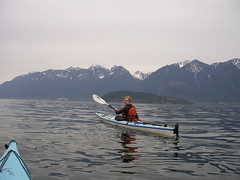
Bowen Island kayak 26/04/08
Su-Laine kayaking at Bowen Island:
“This was a gem of a trip! Evenings, as the kayak rental place told us, tend to have less wind than afternoons. We had flat water and clear skies, and with the snow still in the mountains Howe Sound is gorgeous at this time of year. This is a scenic trip I’d definitely do more than once a year, and with great group dynamics it was one to remember.”