Yearly Archives: 2014

Joffre Lakes, 1 Nov 2014

Jaime at Joffre Lakes:
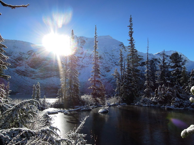
“We headed out for the long drive past Pemberton and up to the Joffre Lakes trailhead. The day turned out to be gorgeous, sunny and frozen. The trail is very different now and most of the way up it’s a hard packed gravel path. The path has been filled in right over the boulder fields so the risk of injury is lowered. It is now a trail that is very accessible to people with all different levels of physical fitness. I think that it’s a good place to take someone on their first bigger hike, or a visiting friend, but I wouldn’t drive all the way there to do it again. It’s a very quick hike now. Snow started on the trail just before the second lake and the terrain was so stunning with the fresh layer of snow. The low, bright sun made it pretty tricky to get any good photos.

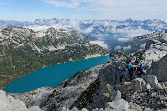
On a side note, we saw a guy propose to his partner at Upper Joffre and she said yes. If we hadn’t been there they would have had the whole place to themselves, so we felt a bit bad about that. It was an almost perfect proposal, except for us.

After the hike we headed into the Pemberton Meadows and along the Lillooet River for a dreamy soak in the springs. The fall colours were so super perfect. I always forget how pretty Pemberton is in the fall. It was a fantastic 2 days with a lovely group of women.”

DSCN7933

West Knob, 26 Oct 2014

Stephen H. at the West Knob:
“Sunday’s forecast-as-rainy day ended up being the perfect somewhat-sunny day. Angela, Svetlana, Nuria, Rebecca, Eugene, and Rasham joined me for a satisfying hike on the Whyte Lake, B-P, and Donut Rock trails to this viewpoint on lower Black Mountain. Views were enjoyed, mushrooms identified, and riddles solved. Trail junctions were easily spotted, though not necessarily well signed.”

Seed Peak, 8 Oct 2014

Steve v. at Seed Peak:
“After a failed attempt last year, I learned from my mistakes and Andy, Pete, Janice, and Danielle joined me for a successful peak bag on a balmy October day.

With more confidence in our GPS tracks and an early start, we were able to guide our driver, Danielle, to the trailhead without issue. She made quick work of the obstacles and a high clearance 4×4 was required.

The trail itself has 4 distinct phases: a clearcut and wooded trailhead, a rolling ridge-like ascent, a barren rocky section with tarns, scree and glacier, and the peak view area (also a ridge). The thing about this trail is that all parts are extremely scenic (especially in fall). In fact, I would consider none of this trail to be the usual “chore” section that exists in most BC hikes.

Wayfinding was needed, but not much, and the drive is very long so do your homework, but I’d rank this as one of the top 10 in the 103 Hikes book (though know the stats under-represent the elevation gain and distance).”

Seed Peak, 8 Oct 2014

Yellow Aster Butte, 5 Oct 2014

Eugene at Yellow Aster Butte:
“This yellow and red wonderland is now at the height of fall colours. And there are still plenty of ripe blueberries/huckleberries over there!

It took us about 2.5 hours (130 km) of driving from Burnaby to reach the turnoff to the logging road toward Yellow Aster Butte. This time included a 25 min border wait (we ended up in the slowest line), a 20-min shopping stop at IGA, and a 5-min stop at the ranger station.

A couple of people ended up taking transit from Vancouver to Langley in order to catch a ride from there. That worked surprisingly well, thanks to the new high-speed 555 bus. Perhaps, Wanderung should add the Carvolth bus exchange to the list of potential meeting spots…

Once on the logging road, it took about 35 min (7 km) to reach the trailhead. The road is passable for small cars, although it’s fairly rough and requires careful navigation, as there are quite a few deep potholes. I was caught off guard a couple of times and ended up slightly scratching the bottom of my Protege, but nothing major.

The trail was in great condition apart from a few wet spots. It wasn’t too crowded, although we did meet quite a few groups, some of them with dogs and small kids.

At 3.5 mi there is a junction; the left branch leads down to the lakes (tarns), and the right trail climbs another 150 m and reaches the butte. As it was still warm enough to swim, some of us went down and took a plunge into the water. It seems that most of the visitors skip the lakes altogether. And yet, those lakes are quite stunning and offer a truly gratifying experience!

Mt. Baker offers some of the most spectacular and yet easily accessible trails within a 100 mi radius from Vancouver. Hopefully, more organizers (and drivers!) will consider visiting the area, as there seems to a be lot of demand for this kind of trips.”

Yellow Aster Butte trail

Burke Mountain, 4 Oct 2014

Stephen H. at Burke Summit:
“A rainy day saw wet shrubs soak the pants and boots of Rasham, Sandra, and I on Burke Ridge. We followed the Club Tread directions, with assistance from a GPS device, taking a logging road much of the way, then the Burke Ridge Trail the rest to the top. Lots of blueberry bushes, mushrooms, scenic ponds along the route. Clouds meant no views on top. Still, the hike to Burke Summit proved to be a mostly enjoyable 6.5 hours.”

Hiking on Burke Ridge Trail near Burke Summit

Deeks Lake, 28 Sep 2014

Jaime at Deeks Lake:
“Four of us headed up to Deeks Lake on a sunny Sunday. Myself (Jaime), Ingrid, Susan and Andrew had the perfect fall day for hiking. The gate at the bottom of the logging road was open so we tried to get closer to the trailhead. The logging road is SO drivable except in one steeper area where it’s pretty washed out. Totally doable with decent clearance. I wanted to go all the way but my rusty undercarriage and wiggly exhaust begged me not to. We made it part way to the TH at least. The hike up was great, really well marked the whole route. Under cover most of the way so it would be a great rainy day hike. We saw some other Wanderungers on the trail, which was a lovely surprise. When we got to the lake I had an AMAZING swim. Swimming in mountain lakes to me is like being in liquid magic. Andrew was brave enough to jump in and Susan and Ingrid were content to shake their heads at us 🙂 We had a long, lazy lunch in the sun. On the way back, that logging road seemed endless and boring. It would be so much better to be able to drive to the trailhead every time. It was a great day!”

Alouette Mountain, 21 Sep 2014

Steve v. on Alouette Mountain:
“This was my 100th hike of the 103 Hikes book (5th edition), and one I wasn’t looking forward to. The reviews from people I knew were not positive, and it was slated to be a full 9 hours for minimal payoff. However, I’m happy to report, it exceeded my modest expectations.

I think for this hike, we hit it on the right day, with the right people. My trip partners (Laura, Lisa and Stephen), all appreciate more than just views. This trail offers a ton of forest walking including old growth and plenty of fertile mushroom areas (not to mention abundant berry patches on this trip!). The temperature was starting to feel less like summer and more like fall which was perfect for the long ascent.

The Blanchard Needle was impressive and right in your face across a deep divide, but I think to make this trip worth the time spent, you have to do the Lake Beautiful side trail (which does not add distance, it is just a choice. In there were the best parts of the old growth. To not do that, 90% of your trip feels just like sections of the Norvan Falls and Lynn Peak trails.”

Alouette Mountain, Sept 2014

Mt Elsay, 14 Sep 2014

Chris M. on Mt Elsay:
“Rob, Colleen, Pierre-Andre and I made it to the summit of Mount Elsay. We did a clockwise loop that took us through various types of North Shore terrain.

We left the main trail at the low point between Jones Peak and the true summit of Seymour. The footbed was clear as we made our way downhill. After going down some boulders we reached the snowfield below Runner Peak and took our first break. Then it was up to a rolling ridge and over towards the junctions – one goes down to the right and leads to the Elsay Lake trail, the second branches left towards Mount Bishop. We ignored them both and went straight. Straight up that is! The final section isn’t that long but the trail builder doesn’t like switchbacks. The summit provides views in all directions with plenty of spots to relax on. Which we did.

On the return trip we went down over the large boulder field towards the Elsay Lake trail. Wonderful large boulders. The others didn’t enjoy this section as much as I did, sadly. At the bottom was the only running water we saw all day and it was just a trickle. Here we stopped to admire salamanders in a mud pond. Once on the Elsay Lake trail we turned south back towards the parking lot. A Korean Group has put in a lot of effort and really brushed large sections of this trail. Once up past Wes’s Staircase we joined into the regular Seymour weekend parade below Pump Peak. It took us about 9 hours and I highly recommend this hike.”

Hanes Valley, 14 Sep 2014

Ronald W. in Hanes Valley:
“The day started with much anticipation as Jenn, Kevin, Melissa, Pooya and Ronald commenced on the Hanes Valley trail.

After 1 1⁄2 hours from the start at Lynn Headwaters, we reached the major creek crossing. The pile of carefully placed logs allowed for an easy crossing. The trail is well marked through the beautiful forest and the dry conditions made for easy hiking. Over an hour later we arrive at the helicopter pad – the perfect spot for lunch. However, minutes later the sounds of a fast approaching North Shore Rescue chopper cut our lunch short, as volunteers disembarked to search for missing hikers that set out on the Hanes Valley trail a day earlier (note: the hikers were found later that day).

The scramble up the well flagged boulder field was made easier with the shade cover from the surrounding mountains. Ensuring we could see the next flag before continuing made for a safe scramble. As we looked back down Hanes Valley the views were breathtaking. The rest of the trail from Crown Pass to the top of Grouse Mountain was a test of endurance and stamina as it entailed more elevation gain, but on a easy to follow and dry trail. Seven hours from the start we arrived at the top of Grouse Mountain. It was truly a spectacular day filled with engaging conversation, majestic beauty and physical challenges.”

Mt Currie Trail, 7 Sep 2014

David P. on Mt Currie:
“Participants: Doug I., Lisa S., Ingrid L., Sandra G., & myself

Driving Times & Distances: 2:45 hours from Park Royal South to Trailhead, with short driving break at Nestor’s Mall in Whistler. From Whistler, travel north on Hwy 99. Set odometer to zero @ Emerald Drive. Drive 14.7 km north, then turning right @ Pemberton Speedway (note no signs for the speedway). From the turn off backtrack southwardly direction on dirt roads for ~2.5 km to Green River Bridge, passing by the Pemberton Speedway oval along the way. The Forest Service Road (FSR) starts to climb to the left (northward). Continue ~ 1 km until spotting some old skis nailed to a sign-post. Trail begins here.

Hiking Times & Distances: It took us 3 hours hiking up to the Pemberton Overlook, keeping a good pace. The return was 2.5 hours down keeping good pace too. This well graded & laid out trail is thanks to the efforts of the Pemberton Valley Trails Association, in 2013. Grades are steady, climbing ~1100 metres from the valley to the Overlook, with several fine view points also along the way. We all enjoyed the newness of the trail with its abundance of organic material covering the roots and rocks. A pleasant contrast to the over-trodden & well rain-sluiced trails like the current BCMC Trail on Grouse. However, the slope is dry and made for some dusty conditions. Options for drinking water are limited, with only one clear creek 1/2 hour from the trailhead. The hiking time & distance to the peak of Mt. Currie would about twice that of getting to the Overlook.

There are two peaks to Mt. Currie. The first peak (lower) is easily visible from the Overlook. The main peak of Mt. Currie, itself, can be described as “ipsoot”, or occluded from the Overlook. “Ipsoot” is Chinook Jargon for “occluded or hidden”. Oddly, there are fine views to be had of Ipsoot Mountain and Glacier across the Green River Valley.

There was a slight delay near the trailhead as there was an active helicopter logging show. Quick turn-around times allowed us to see numerous logs slewed, dropped and stacked. The loggers were very nice and let us through when the ‘copter went to re-fuel. However there was no escaping the continuous sound of the “plop, plop, plop” of the Sikorsky’s rotors, for most of the day!

Photos on Dropbox from Sandra and Lisa