
John K. paddling the Bowron Lakes:
“July 23 to 29 a group of 6 canoeists completed the Bowron Lakes. Moose and mosquitos were the main wildlife. Though there were stories of many Germans on the circuit, these were unfounded. Three fishing rods and 100 hours of fishing produced a 1-pound trout. We almost caught two very large fish (they were this big…) but they both got away. We met a pair of Americans that had pictures of 60-cm trout. The trip was very quiet and we only encountered a handful of other canoes. Two nights we shared a site with another couple otherwise we were alone the entire time. The weather was weird and changed every 10 minutes. Only once was there a real rain storm (and it was nasty – complete with hail) but we were lucky enough to have checked into a cabin an hour before the storm. To watch a storm roll in through the mountains was one of the many highlights of the trip. Average day was leaving camp around 9:00 am and checking into our nightly tent pad at around 5 pm. Fun ensued nightly.”
Yearly Archives: 2011
Mt Mulligan 09/07/11
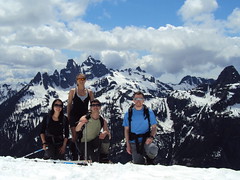
Irina on Mt Mulligan and Anif Peak:
“Following changes to the destination and the participants list, Brad, Melissa and Evgeny joined me for this hike. Brad’s Pathfinder taking us further than expected along the Mamquam FSR shortened the anticipated hike along the logging road by ~4 km each way. After hiking up clear cuts and rarely spaced trees, we found ourselves on the tree-studded Mount Mulligan. Dropped down to the saddle and continued up Anif Peak. The ascent was certainly steeper than I expected, but the snow was perfect for kick-stepping up, and while I was happy to be wearing my crampons, the others managed well without them. A walk along the narrow ridge, and we’re on the summit of Anif Peak. Now that felt like a worthwhile destination, with a close view of the Sky Pilot group and Mount Habrich under blue skies! We settled in on the snow-free south end of the peak and basked under the summer sun for 1.5 hours, enjoying the view and relaxing. It was a breeze getting down to the vehicle through the gully between Mulligan and Anif, leaving us with plenty of time for an enjoyable conversation and an early dinner at the Brew Pub. See full trip report with geotagged pictures on Live Trails.”
Needle Peak 09/07/11
Chris M. on Needle Peak:
“No one was able to join my Gamuza idea. So it was easy for me to change my mind and go up Needle Peak instead. The westbound side of the Zupkios pullout is closed anyway. Snow starts on the trail within the first 15 minutes. But footing was easy, I wore trail runners for the entire trip. Once you start the first scramble it is only on rock the rest of the way. I camped on the final ridge, only minutes from the summit, beside a pretty little tarn. The scrambling is fairly simple, when staying on route! The weather was good with just enough wind so there was NO bugs.”
Donut Rock 03/07/11
Paul T. on Donut Rock:
“The nine hikers set out in search of the ring. Despite some perils, all nine of us arrived safely at Do-Nut (‘doughnut’? ‘doe nut’? — map says ‘Do-Nut’) Rock before looping back over Eagle Bluffs via the Baden Powell Trail. Paul G suggested an additional loop at the beginning which made the trip more interesting. Instead of starting out on the Trans Canada and crossing to the Baden Powell via the Nelson Canyon/Whyte lake trail (which we took on the way back), we picked up a trail that begins close to the parking lot, right at the north side of the old Highway 1 bridge over Nelson Creek. This trail passes through pretty open hillside with lots of arbutus trees before descending to the Whyte Lake trail very near the BP. There’s a fork about 10 minutes along, you need to go right. The pretty and dramatic Do-Nut Rock trail is not that well marked and if you’re doing it for the first time it is easy to lose your way. Also, it is not well travelled and as a result there are some hazards. The steepest section of the trail is up a dirt hillside where there are loose rocks easily unearthed (as we discovered when the organizer sprung one which Maurice in turn swatted away from the path to his head). Best to keep the group as close together as possible through this stretch to reduce this hazard. The trail from Do-Nut Rock to the Baden Powell is also not well marked and there is still patchy snow though it’s easy to walk on, or, around. Whyte lake is warm enough for a swim.”

Flora Lake 02/07/11
Dennis on the Flora Lake trail:
“In my callout, I made a remark about “103 Hikes” time estimates being overly generous. Ironically, it took us the prescribed 10 hours to complete this loop. For some of our party, I’m guessing this hike turned out to be a lot tougher than they had anticipated. Our group of four hit the trail at approximately 11 am. The beginning is pretty straightforward as you follow the book’s (103 Hikes) description and the obvious trail markers. The trail is steep for a good 3 – 4 hours as it meanders along numerous switchbacks. But the payoff is worth it. As you climb, the views of the surrounding mountain ranges are immediate and abundant. The view of the Chilliwack lake below in particular is unsurpassed and truly picturesque. As we slowly approached the col, the trail brought us very near a small but pretty waterfall.
At this point, the steepness of the trail begins to relent and the snow makes its first appearance. By my estimate, our first sighting of snow was roughly at 1250 m. Although the grade of the trail eases, do not let this deceive you – our remaining hike in snow proved to be very cumbersome as we post holed many times. Snow levels were still high due to last winter’s heavy snowfall. This combined with the recent warming of the climate made for very soft, wet and unstable snow. In addition, there were no visible trail markers beyond this point. Following the book’s vague description, Dan, our most experience hiker, and I decided to ascend up the hill to where it meets the lowest point of the ridge. At the top, another dilemma – a fork in our “path”. The obvious choice was to head West towards Flora lake and the general direction of the loop. However, as some of you may know, the obvious route is not always the correct one. We decided to choose by process of elimination. I scurried up the “path” (more of a clearing really) heading East. Since this direction led nowhere, we headed West. Remember, there were no visible trail markers after the first appearance of snow. A GPS, compass and strong route finding abilities are recommended in these conditions.
Over the ridge and past the col the only direction is down. As the others cautiously trudged down the steep snow covered hillside, I quickly changed into my rain gear. My descent down the hill as a human crazy carpet began. No matter how old you get, sliding is always fun isn’t it? Naturally, the others wanted to give it a try. So there we were, the four of us Dan, Ulrike, Grace and myself sliding down the hill. At the lake we had snacks and took pictures. The lake was still mostly frozen and surrounded by snow. Beyond the lake, the trail really got tricky. The snow was so high, there was no obvious path or trail to follow. If you go and this is the case, stick to the book’s description. We did and we stayed west of the lake. Boulder fields anyone? Boulder field after boulder field we slowly began our descent down to Lindeman Lake post holing all the way. With no obvious path and trail markers and cairns hard to spot or completely covered in snow, the natural instinct is to head to lower ground and follow the river. Do not do this. Stick to the boulder fields, this is where the path is and what is described in the book. If you get lost at this point, there are five boulder fields immediately after the lake you must cross before the path becomes visible and clear of snow. We found this out the hard way and briefly got “lost” (though we were always headed in the right direction) for 20 minutes or so before returning to the boulder fields.
After this point, the trail is very straightforward and trail markers are abundant. You know what else is abundant? That’s right, more boulder fields. I counted over 12 boulder fields you must traverse through the course of this loop after Flora lake. The trail down the Lindeman side is beautiful and one that I have done many times. Many lakes, waterfalls and small river and creek crossings abound. We made it to the car utterly exhausted. Well, I wasn’t exhausted, just hungry really :). One last tip before I end this lengthy report. This is a long hike. Book time is 10 hours. Absolutely, positively bring a head lamp and always have at least crampons and sunglasses when travelling on snow. Food helps too. Thanks for the snacks Ulrike and Dan! Now all of you reading, go take a hike!”
Blue Gentian Lake 02/07/11
Paul T. at Blue Gentian Lake:
“Nice half day trip which involved less than 4 hours of hiking (Brothers Creek trail loop counter clockwise with Crossover Trail as short cut on the way back) and good hour of lounging by the sunny lake with few bugs to aggravate us. One slightly tricky creek crossing involved sidling along a bank and climbing up over a large fallen tree. A couple of group members opted to remove boots and wade through lidocaine. The burgers at the Village Taphouse have declined from their former glory, still a decent choan though.”
Juan de Fuca Trail 29/06/11
Steve C. on the Juan de Fuca trail:
“The Juan de Fuca trail stretches 47 km from Jordan River to Port Renfrew on the rugged west coast of Vancouver Island. Shorter and easier than the famous West Coast Trail which neighbours to the northwest, the Juan de Fuca trail still provides a challenging backpacking route, and is a great introduction to the rigors of coastal hiking.
Our JDF team of semi tent-less strangers (four with tents and two with a “tarp”) (Bala, Susanne, Sherron, Pieter, Angela and Steve) assembled at the China Beach campground on Wednesday evening, after a semi-frantic dash to catch the 7 pm ferry and a precarious convoy across Greater Victoria to the campground. That evening had us all falling asleep to the gentle sound of rain and much “tarp talk” emanating from the two brave tarpers. We all learned of the origins of tarp camping and how it was invented by a rocket scientist who no longer wanted to be a rocket scientist but took on a new passion for the outdoors. Out of this was invented the tarp as a way to minimise weight. Rain that night seemed to confirm the discouraging weather forecast, but after it cleared the next morning we wouldn’t see the wet stuff again until our last night of camping. Before we could start the trail we needed to place our two vehicles at either end of the trail. Two hours of car faffing later, our international team (Canadian, Swiss, German, Indian, Dutch and English) was ready to hit the trail.
The first day’s hike to Bear Beach is rated as “Moderate”, and this turned out to be a fair description, with easy terrain but quite a few ups and downs. Much of the trail was in the forest with the exception of a short section around Mystic Beach. The campsite at Bear Beach was quite busy, but we were able to find a quiet spot to ourselves at the far western end of the beach near to the picturesque “Mushroom Rock”. After supper we were all treated to an “Indian style” campfire, differentiated from its Canadian counterpart by the use of accelerant, an interesting grid structure and a higher success rate. The “Canadian fire” the following night (courtesy of Sherron) was however more aesthetically pleasing, hotter and much cosier.
We were all nice and stiff for the next day’s hike to Chin Beach… rather unfortunate as this was the hardest section of the trail. The trail progressed up and over a series of hills and deep ravines for over 10 km, and had a quite a few sections of slippery and steep terrain with plenty of mud. Physical effort was rewarded with a variety of spectacular viewpoints over the coastline, with plenty of photo opportunities. One of these photo ops provided us with the most dramatic moment of the trip. A branch overhanging the cliff edge proved to be an irresistible lure for most members of the team, including Sherron. Sherron’s tree climbing efforts were cut short by an ill-timed loss of footing, and she plummeted like a tranquilized bear down and out of sight over the cliff edge. Thoughts of splattered bodies at the bottom of the cliffs were however soon dispelled as Sherron’s bruised and scraped form emerged from the bushes that line the precipice. The only complaint was from the photographer of the group, Susanne, who said that while she was waiting to take the picture of Sherron, Sherron disappeared!
Chin Beach was busy, more like a refugee camp than a wilderness campsite. Our “go west” mentality was however rewarded with a quieter spot, separated from the main beach by a small headland. Making our food reserves out of reach of the bears provided much evening entertainment. The first food hanging spot was deemed too close to the tents, which was probably a good call as the bags would have been hanging between two tents. The second option (the metal food cache) was no better as it was completely crammed. The third option involved climbing the rocks of the headland in the dark and some nocturnal rope-work. That worked well and both ourselves and the food were still intact come the morning. The night was noisy with a lot of breaking wave action, and it wasn’t until the morning that we realised the water had come up to within a few feet of the tents. Other campers on the main area had to move in the middle of the night to avoid being swamped… and that would have been our fate if we hadn’t of gone west.
Day 3 was meant to be an easier day, but longer in length than the previous two days. The first couple of kilometres proved to be the trickiest of the whole trip, but soon an interlude of easier terrain presented the first opportunity to partake in one of Bala’s famous “side trips”, down to some spectacular Sea Lion caves. There were three takers and three passers. We’re not really sure what happened on that “side trip” but when we rendezvoused again at Sombrio Beach the three side trippers looked well knackered! The section of trail leading up to Sombrio beach was probably the most spectacular of the whole route. The beach itself was however crammed with the leftovers of the Canada Day festivities the night before… making Chin Beach seem comparatively quiet. Leaving Sombrio Beach behind, we headed up into the gloomy forest for an evening walk to the last of our campsites at Little Kuitsche Creek. Along the way, to our great surprise, it was discovered that Steve had remaining six bars of chocolate. As this was the second last day of the trip, speculation was made as to what these bars of chocolate were saved for – perhaps the bears? We were told that a bear had been seen that morning at the Little Kuitsche Campsite. The campsite was in the forest, gloomy and almost entirely full. In the one spot we found we cooked first before putting up the tents, as room did not allow the tents to be put up first. Evening entertainment took the form of force feeding one another leftover food slop, and binging on uneaten chocolate reserves. The tents were up just in time for the overnight deluge of rain.
The next morning brought the end of the rain and a return to the bright sunny weather we had become accustomed to. The last day’s hike to the trailhead at Botanical Beach was a 14-km yomp over mostly easier terrain. There was one more of Bala’s famous side trips along the way, this time to another dubious Sea Lion Cave, through the back garden of the local “problem bear”. This time there were four takers, with the other two opting for the alternative chocolate and nut binge in the sun. We arrived at the trailhead in good time, and after a bit of creative car packing were able to get us all back to the first car in one trip. We were pleased to get onto an earlier ferry than planned, and were treated on the way back to a magnificent sunset and the sight of orcas in the water…. a fine end to a fine trip… A great trail, great weather and (most importantly) great company. Thanks to Bala for organizing this!”
Widgeon Lake 19/06/11
Steve at Widgeon Lake:
“Amazingly, there was still 5-10 ft of snow at the top of this trail (but only at the very top strangely). The journey was far tougher than we expected. Painful boat logistics. An almost not seaworthy inflatable boat for 2 people. A steep slippery root climb for last 2 km. Rain for 70% of it including the chilly snow camping. Even then Widgeon lake is worth a revisit. Though we could barely make out a view, I suspect that the lake islands and granite backdrop would be spectacular. As it was the ice was very interesting (very arctic like). Do this one at the end of the summer when it is dry and make sure to stop by the scenic falls too. This trail could be one of the greats but given how tough it was for me, and how bad the rain and visibility were, my particular experience was only a marginal thumbs up and that was mainly because of the great company and good attitude in adversity (Jamie, Janice, Steve and Kevin).”
Broken Group Islands 28/05/11
Sandra kayaking the Broken Group islands:
“Am I really going to do an 8 day kayaking trip with total strangers?” The cursor hovered hesitantly on the ‘send’ button on the Wanderung callout email I had just written. “What’s the worst that can happen?” I thought, and with one click of a finger I eradicated my indecision and sent it hurtling out into cyberspace.
Day 1: Captain’s Log Star Date: May 28. Travel from Toquart Bay to Hand Island. We are standing at the launch site in Toquart Bay. John is determined to pack what seemed like half a grocery store into his kayak and is using his entire body weight to get his rear hatch cover to close over his frying pan. Dennis, the other paddling partner is compact and has extra space which John happily fills.
Confident that we won’t starve, we launch on a bluebird day and head for Hand Island not more than a few hours away. We land on a sandy west-facing beach and bask in the evening sun. There are purple flowers that line the entire pathway to the solar composting toilet, and if you keep going the path takes you to another secret beach on the other side. Dennis catches a rock crab and John cooks it over a fire while we marvel at being able to see the stars. We fall asleep to the sound of the tide creeping closer and the magic of these islands begins to permeate into a place in ourselves that we hadn’t accessed in a long time.
Day 2: Hand Island to Turret Island (stop to see giant tree) then paddle to Clarke Island. As he approaches shore on Clarke Island, John vaults his paddle like a javelin onto the sand and jumps out of his kayak like the snake in a can of nuts that has just been opened. I sigh and stare at my $400 Werner paddle and vow never to let John touch it. Before his boat is even pulled up and life jacket is off, John is fiddling with the bungees on his boat to free his fishing gear.
“Let’s get these crab traps out!” he yells excitedly as his paddle begins to float away with the tide.
“What have I gotten myself into?” is a thought that would linger in my mind for the better part of the afternoon and evening until I was sitting down with my first ever fresh crab presented on a plate in front of me. “Now tell us what you think of your providers now? Did the men do good or what?”
I think about this between mouthfuls of fresh crab. Even if I was barefoot and pregnant in a time when the First Nations roamed this island, I had to admit I would have still been impressed with their manly abilities to harvest what the ocean had to provide.
Day 3: Paddle around and hiking on Benson Island. I have ambitious plans of a long day of paddling around the exposed outer islands. When I tell this to the boys they stare at me with the eyes that a six year old would give you if you had just asked him to turn the Saturday morning cartoons off to go outside and play.
“But we’re tired and we want to go fishing”. We strike a compromise. Benson Island was close by, we could paddle around it and then land and do a hike to the ‘blowhole’ which was a hole in the rocks that sprayed water up like a fountain when the waves crashed into it.
This pleases them and John plops his fishing hook in the water to troll for salmon on the way over. Benson Island was originally open to camping in, but has been recently restricted to day visits only due to archeological surveying that is currently taking place. The Tseshaht First Nations in the area believe that Benson was the place where their version of the Adam and Eve story took place for their people. Anyone landing on Benson can see why. With rugged shorelines, beautiful sandy beaches and lush old growth rain forest, if life was going to start anywhere, it would make sense that it would be on this paradise island.
Did you catch anything? “No,” says John dejectedly before pulling up his line with some difficulty before realizing that he had caught a fish and just had been unwittingly dragging it around the entire paddle. His eyes light up like Christmas, “A fish! I caught a fish!” We take it to shore and John pummels it with a frying pan, a most fitting object of death for a tasty fish.
Just before we land back on Clarke we notice blows from a whale. We watch mesmerized by this underwater leviathan gently rolling to the surface to breath. Scanning the surface for krill with it’s impressive baleen, it swims further away until its blows disappear into the setting sun.
Day 4: Paddle around Wower Island to Dicebox Island around the backside of Effingham, round Gilbert and back to Clarke. Clarke Island, we were told by the fee collectors, is the best campsite in the Broken Group. We believe them immediately. There was a large sandy beach, the kind your feet loved sinking into, and directly behind was a grassy field that was consistently being mowed by fearless deer who would let you get so close you could almost touch them.
In the morning Dennis and I leave John to bask in the morning sun and we set off to explore the outer islands. As we approached the outside of Wower the waves became more hectic and confused and we bob around on the increasingly larger swell like rubber ducks in a tub filled with rambunctious children. We take shelter between Wower and Bately and watch a group of 30 sea lions on a rocky outcropping try to out-bark each other in a cacophony of sound.
We have lunch on Dicebox Island and try to image what it would have been like to land there 500 years ago and know no other life than this. In these heavily windblown, salty isolated islands life still abounds in lush green canopies and in the boundaries between the tide and far deeper than we can ever see and travel.
Paddling around the exposed east side of Effingham Island we can see what the ravages of wind and waves have done to the spectacular rocky shore. Sea caves and sea arches line the shoreline and we resist the urge to paddle inside as these are sacred burial sites for the Tseshaht people.
Small droplets of rain began plunking and making rings all around us with increasing intensity. The surface of the water started to resonate and shake as if there was an angry neighbour below us banging on his ceiling and yelling at us to stop making all that racket. We unwittingly obey as we silently and soggily paddled back to Clarke.
Day 5: Paddle from Clark to Gibraltar. Little islets and rocks jut up from the surface like flowers that manage to break through cement sidewalks. I try to imagine the tectonic plates underneath us causing the whole bottom of the ocean to fold and bend like peanut brittle. The pressure and friction release exploding underwater volcanoes and whole mountain ranges appear with their apexes peeking out above the surface of the water allowing us to camp on a zenith at sea level.
The site on Gibraltar is gorgeous and even though the beach is gravelly, we are glad to not be in the sand any more. The boys went fishing and I got to the task of setting up a large camp tarp when I noticed an eagle fly closer than I’ve ever seen. Dennis comes back and begins searching for a filleted fish he left on a log. After an extended search we noticed the eagle perched smugly in a tree that towered over our campsite. The mystery of the missing fish was solved: Eagle 1… Dennis 0.
Day 6: “I’ve eaten a lot of dirt on this trip,” says Dennis as he casually brushes off a piece of food that had fallen on the ground. “Well, I’d rather eat dirt than sand,” was my statement that I was about to follow up with seemingly logical reasoning. “Dirt is done and over with, sand lingers in your mouth for a while and grinds down your teeth.” “Yeah, I wouldn’t say it grinds your teeth, maybe it even polishes them, and besides…”
Dennis stops abruptly. “Wait a minute… are we seriously debating over whether we would rather eat dirt or sand?” I think that’s how you know when it’s day 6 of a trip.
Earlier that morning we paddle to the Jacques Jarvis lagoon to catch a 1 foot low tide. Diverse colours of bat stars line the bottom of the lagoon and many tiny fish dart in an out of the eel grass. John and Dennis try to catch scurrying crabs on the sandy bottom with their paddles.
We paddle into a natural fish trap and the entire channel is packed with huge red California Stickapus sea cucumbers. Measuring about a foot long, slimy and with a diameter a bit larger than an actual cucumber, these creatures have soft spikes and look like something they would make you eat on the show Fear Factor.
On the way back the sky opens up with rain and chills me to the bone. Feeling monstrously ill upon my return back to camp I fall asleep in my tent to wake up in the evening to the boys tending to a fire. “The crab curry is ready and we pre-cracked all the claws for you because we know they are your favourite.” Afterwards they cleaned up the dishes and packed away the food while I sat by the fire. I was mercifully grateful that I wasn’t alone on this trip.
Day 7: We leave the gravelly beach of Gibraltar and head to the north side of Nettle Island, cross Coaster channel, through the Pinkerton islands and back to Hand Island. I am packing up some food and tarps, Dennis is tearing down our tent and John is lying on a log in the sun wishing he was dead. That’s the funny thing about alcohol, it’s like an exhilarating roller coaster that always makes you throw up in the end. And no matter how many times it ends badly, you always line up for more.
The passages between the Pinkerton Islands take John’s mind off his unsettled stomach. They are sandy and shallow which gives the water a beautiful tropical look and we feel as though we are floating over a glowing green road to the Emerald City. If we could speak to the Wizard of Oz at that moment, I would wish for a new bladder as I had to pee, Dennis would ask for a new stomach since he was hungry, and John would probably ask for a new brain that wasn’t throbbing. We settled for lunch on a mud flat and then paddled back to Hand Island and John cast out the crab traps for the last time on our trip.
I fall asleep that evening feeling sad that tomorrow would be our last day, but exhilarated at the prospect of soon being able to shower.
Day 8: Hand Island to Toquart Bay. Hand Island gets smaller as we paddle away from it. I take a picture but it comes out looking like a small blob on my camera screen. Pictures never capture the true beauty of what you’re seeing and I try to burn it into my memory. The day is so hot the tops of my hands start to burn and when we arrive to Toquart Bay we don our wetsuits and take our kayaks for a swim and do some rescue practice.
Finally after packing up our boats we walk smelly and salt incrusted into a pub in Port Alberni and watch the Canucks win game 2 of the final series. After a well earned beer, a lingering goodbye we part ways so I can start writing this rather lengthy trip report and prepare for our next trip.
Baden-Powell Trail 12/06/11
Paul G. on the Baden-Powell trail:
“From the MacDonald Creek trail head at Chippendale Road, four of us kept up a quick steady pace as we climbed to the Hollyburn area where we first encountered snow at the lower cabins. By the time we reached the Boy Scout Camp our pace slowed as the trail had 0.5 to 1.0 m snow coverage. The snowpack is still quite firm, however, with minimal postholing. First Lake is still 75% covered. While the snow was gone around the former Cypress Lodge area where we stopped for lunch, the trail in the woods is still covered until just after the Blue Gentian Lake trail intersection. After that, smooth hiking through the Brothers Creek area and down to the Cleveland Dam. It was a great day for a hike!”