Yearly Archives: 2011

Empetrum Peak 12/06/11

Irina on Empetrum Peak:
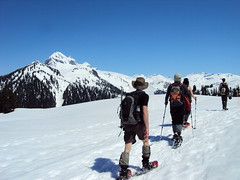
“After breakfast at Galileo, our group of four started the hike from the Cheakamus Lake parking lot. A 2 km trip to the turn-off for the bridge across Cheakamus River, and the trail starts climbing up. Consistent snow started at 1080 m, near the end of switchbacks. Most of the snow was firm enough to walk on in boots as some older footprints suggested, but after each of us postholed all the way to the thigh, putting on the snowshoes was a unanimous decision.

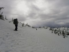
It was a long but pleasant hike following the markers where we could find them. In 3 hours, we were at the meadows with first glimpses of mountain ranges around us. Heading west, we chose our ascent route which climbed to the saddle between two of the subsummits. Good snow quality due to lack of sunshine certainly helped, and after another uphill, we were on the ridge. Claudio and Malin chose to stay there, and handing them one of our radios, Evgeny and I continued to the Empetrum peak. It was only another 30 min to the summit, where we were treated to the close-up views of Black Tusk from this rarely visited vantage point.

After rejoining, we tried another route on the southern side of the ridge for the way back. Would have been doable with crampons and ice axes but not all in a group had them, so we retraced our steps and descended an even gentler grade along the ridge. Stayed too far west in the meadows though, and ended up crossing the creeks hiking down and up steep-ish embankments.

A good hike and fun conversations along the way made it an excellent outing. Thanks to Claudio for offering to rent a car and drive. See trip report with geotagged pictures on Live Trails.”

Empetrum Peak 12.06.2011 025

Eagle Bluffs 12/06/11

Paul T. on Eagle Bluffs:
“Seven of us spent a fine day hiking to Eagle Bluffs, picking up the Baden Powell trail from the Black Mountain trailhead just across from the B.C. Ferries work yard in Horseshoe Bay, doing a loop on the way back via Whyte Lake and Nelson Canyon, returning to the starting point by the Seaview Walk in West Van. We completed the hike in just over 5 hours (past groups I’ve been with have done it in closer to 6; fit bunch this time), with leisurely breaks at the Bluffs, and at Whyte Lake on the way back where the water was just mild enough (at least at the surface) for a swim.

The trail to the Bluffs is clear of snow.

Couple of things to note: the junction of the trail to Doughnut Bluffs (lesser used and not well so well known trail) can now cause some confusion because there are a lot of new, bright trail markers at the beginning of this trail and so it might be possible to stray onto this trail without knowing you had. And, the trail approaching the Bluffs is not very well marked.”

The Gargoyles 05/06/11

Irina at the Gargoyles:
“Ah, finally, the summer is here! Bright blue skies and snow-clad mountains are calling 🙂 Our group of nine started off from the Elfin Lakes parking lot. Snowshoes, although not strictly necessary, went on from the start. We used the winter route along Paul Ridge, and with stops for snacks and pictures, made it to the Elfin shelter in just over 3 hours. Atwell and Garibaldi were seen from many vantage points along the trail, and we were excited to be getting even closer.

For four in the group, it was a second day out in the baking sun, and they opted for staying at the shelter, while the rest of us were eyeing the route to our destination. The decision was made to go up the safe zone until the end of the tree line, then re-assess the traverse below the steep East face of Columnar Peak from there. Instead of the dreaded sugary snow, we found ourselves walking up firm and well-settled snow. Although moist, it held well. From higher up, the traverse looked much more approachable: the longer-propagating sluffs off Columnar were old, and the fresher ones were short runs-offs at the highest steepest portions of the ridge. We continued on to the Columnar-Gargoyles saddle.

The ridge up Columnar Peak was narrow and heavily corniced, while that of Gargoyles, quite a bit wider. Up we went, reaching the West summit of Gargoyles in about an hour of travel from the shelter. Views of the cornices on the East summit killed any desire to explore that peak. Without regrets, we called it a day and relaxed and enjoyed another hour of the beautiful sunny day on the top, surrounded by mountains, breathing in the warm summer air for the first time this season. A tiny speck of a solo hiker was moving towards Little Diamond Head, and the vastness of the white space around him was intimidating.

Returning to the shelter, we re-joined our group and headed back. I hope all enjoyed a great day in the mountains; I sure did, and a wonderful company was certainly a big part of it. Huge thanks go to our drivers Susanne and Darcy. See full report and geotagged pictures on Live Trails.”

The Gargoyles 5.06.2011 016

Stanley Park cycling 05/06/11

Keith cycling here and there:
“It was a great day for a ride. We moved quite quickly through the city, but had time to smell the roses. One rider went down early on on some railroad tracks, but is doing well! It was a great loop, tried my best to keep off totally busy streets as we meandered West, South, East then North. The food? I do not know how it works that you ask random people to bring food and it all goes together so well. (I once had a birthday where nobody talked and there were 7 cakes though…) Veggie lasagna, yam salad, and wild rice with salmon… and a cupcake!! It worked out very well. Here is the recipe for the salad:

Sweet Potato Salad With Orange-Maple Dressing
(Bon Appetit, June 2003)
The salad can remain at room temperature up to two hours before serving. Makes 12 servings.

Dressing.
1/4 cup extra-virgin olive oil
2 tablespoons pure maple syrup
2 tablespoons orange juice
2 tablespoons Sherry wine vinegar or balsamic vinegar
1 tablespoon fresh lemon juice
2 teas poons minced peeled fresh ginger
1/2 teaspoon ground cinnamon
1/4 teaspoon ground nutmeg

Salad:
6 pounds red-skinned sweet potatoes (yams), peeled, cut into 3/4-inch cubes
1 cup chopped green onions
1 cup chopped fresh parsley
1 cup pecans, toasted, coarsely chopped
1/2 cup golden raisins
1/2 cup brown raisins

For dressing:
Whisk all ingredients to blend in small bowl. Season dressing to taste with salt and pepper.

For salad:
Steam sweet potatoes in batches until potatoes are just tender, about 10 minutes per batch. Transfer sweet potatoes to large bowl. Cool to room temperature. Add green onions, parsley, pecans, and all raisins; Pour dressing over; toss gently to blend. Season salad to taste with salt and pepper. (Can be made 2 hours ahead. Let stand at room temperature.)”

Mayne Island cycling 04/06/11

Markus on Mayne Island:
“Seven of us headed out on a spectacular Saturday to check out the wonders of Mayne Island. In seven hours (coincidence?) we managed to cover most of the north of the island at a fairly relaxed pace, stopping at the Farmers Market, Georgina Point and Edith Point for a wander about/hike. We then headed inland to Mt. Parke and hiked up to Halliday Lookout where we had lunch while taking in the spectacular view of the Gulf Islands. I would recommend doing this as an overnight trip as there is still plenty more to see.”

Stanley Park cycling 29/05/11

Markus cycling the sea-wall in Stanley Park:
“Shout out to Rob M and Oksana for joining me in what has to have been the most laid back call-out I’ve ever been on. The weather was perfect for the myriad of stops that we made on the way. From investigating tidal pools around Stanley Park to finding little tucked away waterfalls around False Creek, we covered a lot more than just the distance from start to end.”

Lighthouse

Baden-Powell Trail 22/05/11

Paul G. on the Baden-Powell Trail:
“Seven of us took in this hike along the base of Fromme and Grouse. The undergrowth is greening up nicely and the black flies have arrived. We were teased by the sun for a few minutes, but as we approached East MacKay Creek, the fog thickened, the forest darkened ominously and the skies opened up. Heavy rain and hail, but no frogs. Maybe next year 😉 (2012).”

Mt Gandalf 21/05/11

Ben at the Brian Waddington Hut:
“Despite the dramatic disappearance of the sun this weekend, our group of five met up and headed north with hopes of finding clearer skies. The road to Birkenhead Lake was clear and in good shape all the way to the lake. We turned off at the branch immediately before the gate to the campground and parked nearby, facing 6.6 km of logging road to walk to the trailhead. Along the way we passed up a VOC group heading up with skis on their backs. At the end of the road we had lunch and let the skiers take the lead. The trail was short and very well marked as it winds up the forest along Phelix Creek. It was however challenging in the soft melting snow with heavy packs. Eventually we crested a small rise to see Long Lake and the hut awaiting us at the far side. The weather had been grey all day and it didn’t look like the situation was any more promising up here. The hut deserves its good reputation. The evening was a relaxing mix of cooking, reading selections from the library, and enjoying the skiers’ renditions of old Bob Dylan songs on the guitar.

The next morning the snow was falling and we left the hut to stretch our legs. We had no real expectation of reaching any summits, but we decided to make for Gandalf-Peregrine col and see what things looked like. After a couple of hours we found ourselves at the col having the turn around time discussion. We had plenty of extra time so we decided to invest another hour and take it a step at a time. We began to switch back up the end of the ridge leading to Mount Gandalf. We couldn’t see much but we knew that up there somewhere the white wizard was waiting. Progress was steady thanks to Brad’s trail breaking effort, and before we knew it we found ourselves standing below huge boulders. With less than 100m to gain, we knew we must be close. From here Pavel lead us on a true showshoe scramble as we moved up bare slabs, boulders, and the snow that filled the gaps between, not bothering to stop and remove the snowshoes. One final block split the group into three as we picked our preferred routes over or around the rock. After converging and counting heads, we moved on. Then out of the mist appeared the great unmistakable flake standing like the final stone on some great summit cairn. We were there! Congratulations all around! A huge thanks to Brad, Pavel, Rob, and Darcy for their contributions to this very memorable trip.”

Gandalf peak, 05/22/11

Mt Gardner 21/05/11

Carollyne on Mt Gardner:
“Even with the very low overcast clouds and showers, this trip was excellent. One goal was not to get lost, unlike every other time I’ve done this hike, and we didn’t, even though the route wasn’t totally as planned. Thanks go to VOC Wiki’s excellent map, Vancouver Trails info and the much improved signage. We intended to take “The Handlogger’s Trail” (Mat Hill trail in 103 hikes) to N. Mt. Gardner trail. Shortly after we began we found a crevasse of a washout. Although the stream flow was low and it would have been easy to cross, this route no longer looked promising so we double backed and took the road until N. Mt. Gardner Trail. From there it was straight forward to the ropes and the helipads, with 360 degree white wall views of cloud. Following a short lunch break, we returned making a loop via the trail near the opposite helipad, the S. Mt. Gardner trail. Total time: 5 h 15 min Cove to Cove. We finished off with dinner at Doc Morgan’s and were back in Vancouver by 6 pm. Other than the washout, the trail was in excellent condition and not muddy. I also picked up a good free map, “Bowen Map & Guide 2011″ on the ferry that seems to include all the trails on Bowen.”

Panther Peak 21/05/11

Ahmad on Panther Peak:
“I was first surprised by the lack of signage to the park. I expected at least the regular provincial sign that I am used to seeing in provincial parks. Second, I was surprised by the lack of people especially for the long weekend. There are four cabins in the park and I think the park is underrated. We only saw 6 people in total.

I wasn’t aware of NcNair Cabin which was a treat to find near our destination. It seems most people in winter head to Edwards Cabin and some to Steele Cabin. The trail to Edwards Lake was broken but there was again lack of markers but might just hidden in snow. It could be better in summer.

After Edwards Cabin, we broke the trail towards Chapman Lake. The trail crosses Chapman Creek about half way but we missed the turn and we became on the other side of the lake. We reached a creek that we couldn’t cross. We had four options: return to Edwards Cabin, turn back and look for the bridge that we missed, camp where we were, or cross Chapman Lake. We chose the last one. The lake was melting in some sections but we managed to cross it without a problem but I expect it will not be crossable any more soon. McNair Cabin was in good condition and it is located truly in serene location.

Our objective was to summit Panther but I was pretty exhausted from the night before. I also had some concerns of crossing the lake on the next day and the tight schedule for the ferry. I think this is an awesome place to spend an overnight if not more.

Photos, movies, and GPS track on Live Trails.”

DSCN5737