
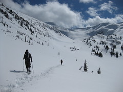
Ben trying for Coliseum Mountain:
“It is a bit too early in the year to find favourable conditions on this hike. The snowline was at approximately 825 metres and the terrain at this point on the trail is quite rugged. Ugly postholing and slushy snow on the steep slopes made for an unpleasant time. We reached Paton’s Lookout to find ourselves in the middle of a thick cloud. There was only a slim chance that the weather or the snow would improve if we continued, so we decided to turn back and call it a day. I look forward to returning here later in the year.”
Yearly Archives: 2011
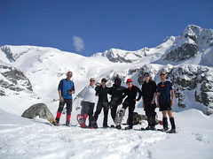
Wedgemount Lake 01/05/11
Dan at Wedgemount Lake:
“Finding ourselves with more sunshine than forecasted, we upgraded our destination and headed to Wedgemount Lake for this glorious weekend. The snow was vastly more abundant and better than last winter; there was hardly any no iciness. A congenial group of seven with varying levels of experience, we snowshoed the entire way with only minimal slipperiness. Routefinding did not pose any problems on this trip.
We reprised last spring’s approach and headed up a ridge beneath Mount Cook – descending back down onto Wedgemount Lake – and bypassed the steep and avy-looking summer route. Once at the lake, we witnessed a few cornice-triggered avalanches. Calum videoed one and it is posted on the Wanderung Flickr site.
Three of us then headed across the lake and onto Wedgemount Glacier. We were awestruck by the vast jaggedness of Nature’s beauty, with brilliant vistas and rugged wonders in every direction that took our breaths away! Let me tell you, this is a must-see winter locale if pristine alpine nature is your thing. We did not run into a single soul the entire day! More photos on my Live Trails report.”
Upper Shannon Falls 01/05/11
Steve at Upper Shannon Falls:
“Either I’m out of shape, or someone added a big mound of rock, and few extra clicks to this trail. Probably more the first one… I totally underestimated this as being a short/easy hike despite hiking it before. It is more like a shorter version of the Chief trail with some nice flat bits thrown in. I had a really great group of women sign up (yup, you heard me!), but thankfully the conversation steered clear of the recent Royal Wedding which was my big fear. We took in the falls and the viewpoint, but it took us over 4 hours (moderate pace). This one reminded me of old Wanderung hikes circa 2002 for some reason and I enjoyed it.”

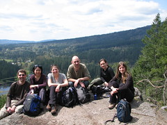
Minnekhada Park 01/05/11
Markus at Minnekhada Park:
“Six of us enjoyed a nice hike around Minnekhada Park. Be aware that there are two parking lots along the road to the park. The first one appears right after you cross a bridge and is next to a trail that takes you to Pitt River. You’ll want to carry on to the second one and be sure to get there early if it’s a nice day as the lot fills up fast. The route we took was hilly but got us to the High Knoll lookout in good time. Thanks to Kelly for driving.”
Mt Rohr 26/03/11
Ben V. on Mt Rohr:
“The wind was calm, the skies were blue, and the snow was perfect for snowshoe travel. We left the city eager for some time in the alpine. The route to the lake was mostly easy to follow along tape, ski tracks, and some nearly buried orange markers. We found the sign for the turnoff to Rohr Lake just above the snow at ankle height. A bit of routefinding was necessary from this point up to a small clearing below the lake. From the lake it was smooth sailing straight up the valley floor with plenty of alpine scenery to enjoy. We approached the summit ridge from the northwest and took a nice line to the top with only one excessively steep section requiring us to drop down on all fours. The summit was surprisingly hospitable and we were able to sit down and recharge while we soaked up the panoramic views. A big thanks to Adrian and Dan for making this a great trip.”
Lost Lake Shelter 26/02/11
Robert D. at the Lost Lake shelter:
“Originally planned as a 2-day, we decided to condense this trip into 1 day with an earlier start. Three of us assembled at 6 am and made our way to the handy parking lot just south of Porteau Cove, the access point for the northern end of the Howe Sound Crest Trail. The trail to Lost Lake shelter follows Kallahne Creek. The route on the ascent was very slow going due to trail breaking in heavy powder. The trail is not the easiest in any condition due to numerous awkward creeks crossing it. It took us 5.5 hours to reach the shelter which was a welcoming place to rest for a late lunch. The shelter itself, situated on the western edge of Lost Lake, is rustic but reasonably maintained and can hold about 6-8 people. The conditions and bad visibility negated any chance of continuing to Deeks Peak but an overnight trip to the bag the peak would be worthy of a future call out. The descent took just 2.5 hours.”
Alouette Mtn 19/02/11
Ben on Alouette Mountain:
“The day was bright and the trail was long. If you are seeking a route that offers some views along the way, look elsewhere. Prior to reaching the summit there is basically nothing to see except stretches of old access road. The portion of the trail that overlaps with the old road is well marked, with wooden signs indicating the turn off points. Beyond the final turn off the markers are a lot more sporadic. Bring your route-finding and tape-spotting skills. We were lucky to be passed at this point by a group of locals who blazed the trail forward. The snow was in good condition. It was fresh but beginning to consolidate. At the top we enjoyed the close up view of the Blanchard Needle, and then retreated from the wind to have our lunch in the shelter of some trees. Thanks to Adrian and Lori for joining me.”
Mt St Benedict 05/02/11
Ben on Mt St Benedict:
“We stayed dry but we have no views to report from this trip. The clouds that hung on the ridge in the morning did not break for us. This hike has potential as a nice winter alternative to the popular North Shore standards. It is accessible in any vehicle and the trail is easy to follow. If you go anytime soon, be prepared to lug your snowshoes up a few hundred metres before finding any snow however. There is also a section of logging road/stream bed to expect. The turn-off of the trail from the road is marked by an old pan, and is pretty easy to spot. We put on our showshoes around McKay Lake and picked our own trail up the ridge. The snow beyond the lake was crusty. Atop the ridge we headed south towards the summit, seeing occasional markers along the way.”