Yearly Archives: 2008

Rainbow Lake 30/08/08

Carollyne at Rainbow Lake:
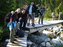
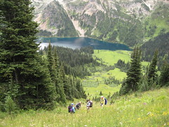
“Seven of us enjoyed each others company on the hike to Rainbow Lake. The trail is in great shape, with the exception of a few mud holes – one large enough to nearly swallow one of our hikers, and after 2 p.m. we had the trail to ourselves. The trail crosses creeks several times with well-constructed bridges, gives views of waterfalls and mountains along the way, and becomes a boardwalk going through meadows – no longer in bloom, but beautiful anyway. When we arrived at the lake for lunch, it was a bit cold, breezy and overcast, but thanks to Donna’s suggestion, we had a further goal – to try to find a trail branch with a glacier viewpoint. We weren’t sure whether to aim for Hanging Lake or Rainbow Mtn, but after looking at the map and Erez’s GPS, we decided to head for Rainbow Mtn, at least until we ran out of time. We never saw a glacier, but the boulder-strewn mountain/meadow vistas were by far the best part of the hike for those who had the energy to get there. This area is worth at least an overnighter to enjoy, and we were very sad to leave. A 5-minute hailstorm once we were in our cars and great burgers in Whistler were some consolation.”

Rainbow Lake Group

Phyllis Creek 30/08/08

Steve at Phyllis Creek:
“No bugs, no bears, no real reason to go back to this one. There were 3 highlights to this trip: the people, the after-hike dinner at Pondok, … and putting the checkmark in my book. Most of the time on this hike was spent wondering if we were on the real trail. Following orange tape can be problematic when at the highway there were 3 spots marked with orange tape. Most of this trip was a logging road, and the true low light was the slippery log section through prickle bushes (though it did explain why Brian Grover quoted such a long hike time). I wouldn’t recommend this especially because though it ends a 2 little lakes, we couldn’t find a way to get near them and no beach was evident at all (we ate lunch looking down over them). Did I mention the powerlines?”

Thimble berry

Hayward Lake 24/08/08

Anne at Hayward Lake:
“Four of us met on an already rainy Sunday morning in Vancouver. We decided that driving all the way to Chilliwack just to find the same rainy conditions there wasn’t probably worth the effort – so we followed Dave’s suggestions to go to Hayward Lake Reservoir in Mission. It’s a 16km hike around the reservoir, half of it gently rolls up and down through the forest; the other half is a flat open railway trail. The trail also passes by the dam, Dave pointed out that sometimes they offer tours there. We actually managed to start with no rain – unfortunately it did not last for long. The rain set in pretty soon and once we left the the forest covered part of the trail we got soaked pretty quickly; at this point it had turned into pouring rain… By the time we got back to the car, it was with and without GoreTex just dripping down on us… Nevertheless we all got a good workout and fresh air (and the proof that we are waterproof hikers!)”

BCMC Trail 23/08/08

Michelle on the BCMC/Larsen trail:
“What a zooo! Grouse was pretty much the busiest any of us had seen. The parking issues a number of us encountered should have given us a hint at the line up we would have to face for the tram down. A few opted to endure pounding the Grind down in reverse rather than standing there helpless in the mile long line. And one actually beat us down! Thankfully the trail itself was quiet and peaceful.”

Tricouni Peak 23/08/08

Ahmad on Tricouni Peak:
“Perhaps the hardest part of the hike is the 10-11 km logging road to the trail head. It is a rough road and there is a little chance that a small car can reach 8 km as it is described in 103 Hikes book. In our experience, a small car could hardly reach even 2.5 km. Fortunately, the other driver had a Jeep and the seven of us jammed inside it with his two dogs. The dogs seemed very amused how jammed we were. Perhaps they liked our camaraderie spirits. There are several turns on the way and I found the instructions of the 103 Hikes confusing. We then found out by trial and error that the road marked with ribbons is the main and the right road. The trail starts with muddy sections, which continues for next 3 km. Gaiters are a must and poles will help too to check out the best spot before you land on it. Heading to the peak requires some scrambling but I didn’t find it too technical or exposed. Perhaps we followed the easiest way up. The peak requires more scrambling but I didn’t find it hard and all of us summited. There are lots of lose rocks and I recommend helmets. We didn’t have many views because of the cloudy weather. We met few groups. One of them climbed up from Roe Creek on a demanding route. Our whole trip took 8 hours. Special thanks for our drivers Andrew and Eric. Thanks for Irina for her tips on the trail.”

Tricouni Peak 198

Elsay Lake 23/08/08

Tim at Elsay Lake:
“Tim, Justin and Alex hiked to Elsay Lake on Saturday. The trail to Elsay Lake is well maintained and easy to follow. However this is one of the most remote trails in Seymour Park and seems to be rarely used. We saw no one all day. The trail leads around the east side of the Seymour peaks (all cliffs), across boulder fields, down some steep rough creek beds and through old growth forest. There are occasional views of Indian Arm below to the East. The lake is the largest in the park, is picturesque, and has large brown salamanders/newts swimming in the shallows. However the last third of the trail to Elsay Lake drops about 600 m down to the lake. It is a real pain to regain that elevation on the way back, especially since the round trip is an arduous 20 km. A far better option would be to avoid that elevation drop and take a side trail westwards up to Mount Elsay (i.e. forego the lake for a better view from the mountain top). The junction is about 2.5 km before the lake, at 050717, and comes a few yards after crossing a rockslide at 050716. Although marked with orange flagging tape, the Mount Elsay trail starts out as a very indistinct path and the junction is hard to spot. However this trail soon pops out into a big boulder field about 500 m west of Canadian Pass. The route up to the top of Mount Elsay is obvious from there.”

Elsay Lake

Tenquille Lake 23/08/08

Chris at Tenquille Lake:
“Cara, Dean, Lucy and Michele joined me on a trip into Tenquille Lake and to share the joys of west coast weather. The Hurley had just been graded so, though the surface was loose, the potholes and washboarding were gone. Branch 12 (the Tenquille branch) had some large water bars right from the start but the Isuzu Trooper made it through without a problem courtesy of Cara’s driving skills. The alder was pretty overgrown so we got some pinstriping but, on the way out, we met a couple guys who were in the process of cutting it back. The trail was in pretty good condition with only a couple blowdowns right at the start. Even with a stop for lunch (and berries) we made it to the lake in about 3 and 1/2 hours. After setting up camp, Dean took off to scamble Tenquille Mt. and Goat Peak (and saw goats!) while the rest of us went to Finch Ridge to gaze at the unlogged vista to the north. The next morning lived up to the worst of the forecasts Michele had seen for the weekend: “Rain, heavy at times”. It turns out that the cabin at the lake is in pretty good condition considering that it is 60 years old – kept the rain out and the resident mouse was fairly quiet. Wearing as much waterproof stuff as possible (Cara fashioned a poncho out of plastic sheeting from the cabin), we hiked out stopping only to graze on more berries (easier to pick with your teeth than with gloved fingers).”

Tenquille Lake 004

Mt Marriott 17/08/08

Ahmad on Mt Marriott:
“The job was not done. We got to within 200 m distance and 100 m elevation of the summit. Our start was rather slow. One of our three-person group didn’t feel well in the morning and decided to stay at the shelter in the meadows. Darcy and I started our push for the summit at 12:30 pm. We followed a different route described in Matt’s scramble which is briefly described in his updates. We had three different ways of how to get up on the cliff that leads to the proper ridge. We chose the most difficult one of course unintentionally. It included lots of scrambling and 2 rock climbing spots. One of them was over 8 m wall. However once we were on the cliff, the trail became considerably easier but the rocks were still rough and continuous concentration was required. At 4:20 pm, I found that it became too late to continue and aborted our attempt. On our way back, we followed the second option and I found it easier and more direct although you have to go through one of the climbing spot but it is the easier one. We got back to the shelter at 7 pm and to the car at 8:30 pm and the whole trip took 11 hours. Beautiful views and lots of wildlife. We even saw fresh cougar track on a snow field. Special thanks to Tim Gage who provided me with valuable information about the trail.”

Pemberton cycle tour 17/08/08

Dana slow-food cycling around Pemberton:
“My hiking/biking overnighter ended up being a day trip, which made for a long but wonderful day. Ulrike, Haseena, Paula and I enjoyed Pemberton’s Slow Food Cycle Sunday on a very hot day covering 52 km of riding. (Having never done the event, I thought it was 26 km and it was, one way that is!) To start the day, our teamwork helped to get Paula’s bike on the bike rack, vertically, as it didn’t have a cross bar. Early morning was cloudy and it rained lightly at the beginning of our ride, but the day turned out to be incredibly warm. Picking up the event map at the Pemberton Community Centre, we then rode along and stopped at all of the designated farm stops and rested and enjoyed such fare as fair-trade coffee, potato rosti with smoked salmon (from an executive chef from a Whistler restaurant!), natural beef burgers, iced tea, strawberry coffee cake, and more. I bought some potatoes and zucchini to bring home. It was neat to see how many people took place in this free event, including families. The `course’ followed the flat Pemberton Meadows Road and the milky-looking Lillooet River. After the long ride, grimy and sweaty, we cooled off with a swim in Whistler’s Alta Lake before heading to Squamish for a cold beer and dinner and, finally, home. A truly wonderful day with great company and an event I’d highly recommend! A special `Good on ya!’ to Aussie Paula who hadn’t been on a bike in many years and did awesome! Look for upcoming photos from the trip on Flickr.”

Km 13 - "Slow Food Cycle Sunday" Pemberton, Aug17 2008

Mt Strachan 17/08/08

Hurrian on Mt Strachan:
“Despite all of the weather forecast warning, which made us pack useless raincoats up the trail, we had a beautiful day for our Mount Strachan hike. We wandered on and off trail, trying to find the right route, all the while breathing in mouthfuls of fresh mountain air which had that delightful crunchiness that only bugs can give it. We got to see the ruins of a forty-year old plane crash on the mountainside just before the final steep section up to the summit. At the top, we lunched looking out over Vancouver before exploring the views on other parts of the summit. Wanting a shorter day, we took the road down from the summit and headed home, stopping at Park Royal for a very refreshing snack. Great trip and great company.”