Yearly Archives: 2008

The Lions 16/08/08

Merewyn at the Lions:
“We had a great day with marvelous weather, gorgeous views, and fun company. The trail has definitely been rerouted to some degree due to downfall but it is still pretty easy to find your way (though we also discovered it was quite easy to lose your fellow hikers by taking slightly different paths). There were a few patches of snow left near the top; far from being a nuisance, we used these to cool down as it was a scorcher. The rest of the trail was through forest and was surprisingly cool. All in all, a fantastic trail with amazing views – this one is definitely a keeper! Thanks to Andy and Craig for driving!”

Lions - Binkert Trail Aug 16 08 - 51.jpg

Goat Mtn 16/08/08

Steve on Goat Mountain:
“Nine of us met at the foot of the gondola at Grouse and took the skyride up to the trailhead. It was hot, damned hot, but the views were rewarding and I was thankful we had not done the Grind on the way up. There wasn’t much shade to be had and my current lack of conditioning was made worse by the heat. Many of us underestimated how fast we would go through the water and had to share. You should be warned that the crowds at the skyride are insane, but the Goat Mountain trail itself was quiet. A big thanks to first timer Angele who not only knew the trail well (I didn’t have to pull out my book) but also has one of the most impressive hiking resumes I’ve heard in a long time! Fun group too! The trip was only made better when a medical doctor actually recommended I drink a coke after a hike…”

View from Goat Mtn.

Elfin Lakes 16/08/08

Carollyne at Elfin Lakes and Opal Cone:
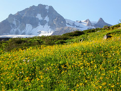
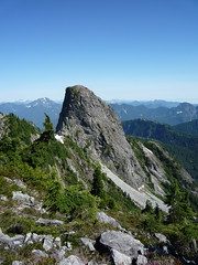
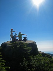
“Six of us hiked with our backpacks to Elfin Lakes on a hot, clear day with spectacular views of the mountains and meadows. Although it was busy at Elfin Shelter, there were enough bunks in the shelter for all of us when we arrived there at 1 pm. After unpacking and having lunch by the lake, we hiked out to Opal Cone, which turned out to be a bit of an adventure. As we began our descent to Ring Creek, we met a couple of hikers turning back saying the trail was gone, others who had made it but warning us to get as much water as we could. We continued on and found the slope must have had a recent landslide as the descent was what might be called a goat track in soft, dusty moraine. We made it down and then boulder-picked our way across the first fork of Ring Creek, with wonderfully clear water, across more rock, then finally across the bridge over the raging second fork. Going up the incline, the group separated, with the three fastest hikers scrambling up a direct route with difficulty. Ted and I found, then lost, then found the marked route with its long switchbacks – which we all used on our return. Atop the ridge, a stunning contrast was before us, with a green and flower filled bowl and a lovely trail which we followed to the end of Opal Cone ridge. Four did the last scramble up to the snow filled crater, while the writer enjoyed the view and the pikas (much larger than Columbia Ground Squirrels). We returned, very tired, to a now very full Elfin Shelter, by 7:30 pm. A full moon, three lovely kids and choral snoring stand out as memories. Sunday morning, with light showers chasing us, we returned home, glad we endured the heat to see Opal Cone on such a brilliant, if hot, day.”

opaltrailview

Johnstone Strait Kayak Tour 16/08/08

Sandra kayaking the Johnstone Strait / Broughton Archipelago:
“Our group of 8 headed out for a great 6-days on the water around both the Johnstone Strait south of Telegraph Cove and north through the Broughton Archipelago (as far north as Insect Island and Echo Bay). We got a little of everything… Half the time there was beautiful sunshine but we also had a day of rain. The winds picked up for sections of our days (including one “exciting” crossing with waves from both current/wind, and also from the wake of a cruise ship!) but we also had wonderfully calm days. Campsites ranged from amazing island set ups with wooden structure outlines ready for tarps & tree swings to simple clearings in the woods. We had lazy easy days and a couple long paddle days.

Highlights from the trip included seeing porpoises everyday, orcas half the days, visiting First Nation reserves / abandoned communities, campfires every night, amazing food, freezing dips in the ocean (did I mention the WARM campfires?!?!), navigation practice during early morning fogged-in paddles & hunting down camping areas amongst the islands and the distance we got from the crowds of Johnstone Strait. Good times on and off the water!”

Pre-breakfast paddle, navigating only by compass through the fog

Mt Strachan 16/08/08

Paul on Mt Strachan:
“The plan had been to approach Mount Strachan via Strachan Meadows, or the ‘back side’ route. A fellow Wanderunger reported that two weeks ago, when his group took this route, there was still a couple of feet of snow along the steepest section of the approach rendering it slightly treacherous. Therefore we elected to change the route up and take the Baden Powell/Old Strachan Trail route. We stuck to the original plan of returning via the ski runs. A couple of notes:
1. If you are taking the Baden Powell/Old Strachan Trail route and using Dawn Hanna’s Best Hikes and Walks of SWBC as a guide, ignore her trail directions which are (to put it mildly) misleading. Follow these directions instead:
–take the Baden Powell Trail east from the park map at the down hill ski area parking lot
–the Old Strachan trail (not labelled as such) is on your left, about 15 minutes along the Baden Powell, at it’s first junction. It is marked by a wooden sign which indicates that the Baden Powell continues east. You want to turn north (left) and take the unlabelled trail (unlabelled as opposed to unmarked — it is quite well marked). There is some blow down directly at the entrance to it, and a fair bit of blow down all along the trail, none of it that difficult to negotiate.
–You will encounter one more trail junction. Go left rather than right.
–Trail then will take you to the first summit of Strachan if you choose to follow it all the way. It coincides with a ski run a couple of times. At either point you can elect to leave the trail and continue on the ski run which also ends up at the south summit.
2. Summits. Strachan has two summits, south and north. The views from the north summit are much more impressive than those from the south (the view of the Lions is unimpeded), and so it is well worth hiking the extra 20 min or so it takes to get from south to north summits.
3. Strachan Meadows route: state of the trail. I hiked down the back of Strachan a little ways to check trail conditions. I could see snow, but it looked to me as though most, if not all, of the snow had melted away from the trail itself. Probably soon ok to take the Strachan Meadows route.
4. Ski run return. In past years the only available ski run to return by was a blue one (beginners’ run) a series of gradual switch backs ending you up at the down hill ski parking lot starting point. We found ourselves on a newly created run, the Bowen, an advanced run and obviously quite steep. We decided to try our luck rather than doubling back up, and a couple of us found sections of it a bit tricky to negotiate. Recommend sticking to the blue run for the return, if you plan to return via runs (and before you begin the hike checking the ski run map at the parking lot to orient yourself).
5. Timing. Saturday was the first time I’d hiked to Strachan by the Baden Powell/Old Strachan trail route. It is significantly longer than the Howe Sound Crest/ Strachan Meadows route. Allow 7 hours for the round trip (it took us about 6, including an extra half hour of needless hiking before we determined the location of the Old Strachan Trail.”

Mt Seymour 13/08/08

Chris M. on Mt Seymour:
“After work Wednesday, 4 of us headed up Seymour. Started hiking just before 5. The others were willing to let me lead them `off-trail’ and we scrambled up the south face of Pump Peak. I think they enjoyed it. Then over to 2nd Peak and finally two of us went to Seymour summit for some picture time. Great weather and down before dark.”

Brandywine Mtn 10/08/08

Ahmad on Brandywine Mountain:
“Eight people accompanied by rain and clouds got to the summit of Brandywine. The trail to meadows is well marked but it has many roots and slippery in some sections. The trail to the ridge appears and disappears across its 400 m elevation gain and requires some type of navigation aid to select the best route in whiteout situation. It would be better if the weather was clear. The ridge itself has quite a considerable number of cairns and is easier to navigate. The entrance of the logging road that leads to the trailhead is closed but there is a way to get to it. You have drive 1 km further north and turn left on Callaghan Way. After 200 m turn left again. You will see a white building shortly and select the left logging road and after 1 km, it connects to the Brandywine road. Perhaps the road closure was the reason that we didn’t see anyone on this hike. The whole trip took 10:30 hours including a considerable number of breaks.”

BCMC Trail 10/08/08

Hurrian on the BCMC Trail:
“Six of us set out (including a first-timer — welcome Omid) up the BCMC this morning. The cool weather was perfect for the ascent. As usual the BCMC was more peaceful and friendlier than the Grind. At the top we stopped for lunch and a chat. Afterwards a couple people carried on to Goat Mountain and one took the Skyride down. The big adventure on the descent is that we stumbled upon the fabled Flint and Feather trail. As per legend it did have stunning views over Vancouver, few hikers and short scrambles down a few cliff faces. It also had hikers with very proprietary attitudes about the trail. (They told us not to tell anyone about the trail and not to walk down this trail as it causes erosion. The trail was surprisingly easy to find. First you start down the BCMC trail and then xxxxxxxxxxxxxxxxxxxxxxxxxxxxxxxxx…… This section has been censored by the Flint and Feather Protection Front (FFPF) — Do not attempt this trail. Do not talk about this trail. Ostracize those who do not follow these instructions.

Petgill Lake 10/08/08

Maia at Petgill Lake:
“Thanks to Tim’s feedback to the hike call-out we (Eric, John, Ming, Maia) knew that it may be difficult to access either one of the two trailheads to Deeks Lake because of the Sea-to-Sky highway construction and our plan B was to do the Petgill Lake hike. There is no pullout at Deeks Creek. About 4 km later there was a sign `Deeks Lake trail 1000 m’ announcing the other trailhead, but all we found after 1 km were two seemingly lost hikers on the highway and no pullout for the Deeks Lake trail.

So we proceeded to Petgill Lake; easy parking and a well-marked trail. It starts with a steep rocky-rooty section until the first lookout and then levels off, follows a partially overgrown logging road for a while and goes back into more softer, steeper grounds and up and down a bit. We arrived at the lake after two hours of hiking at a moderate speed and decided to walk around the lake before having lunch, which made us discover the viewpoint about 10 minutes from the lake looking down onto Howe Sound. We ate and cooled down and were not really eager to go swimming; it was windy and overcast. Returning to the lake we tried the water and – surprise – it was really warm, so swimming got back on the agenda and was very pleasant indeed. We arrived back at the car after 6 hours. Driving back we checked again at Bertram Creek/Deeks Creek and it really is unclear where one could leave the car and where the trail starts.”

Eric, Maia, Ming and Petgill Lake

Mt Seymour Potluck 09/08/08

Eric A. on Mt Seymour in Lynn Canyon:
“Three of us enjoyed wonderful food and great company. We decided that Mt Seymour was a little too soggy for our liking so we decided on a nice walk at Lynn Canyon. We enjoyed some great middle eastern cuisine as well as chocolate and strawberries. Blueberry pie was also served.”