Yearly Archives: 2008

Blowdown Cabin 18/10/08

Chris at Blowdown Cabin:
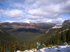
“It was an impromptu reunion of the Halymore-Melvin trip with Cara, Dean and Quirine joining me. The Blowdown Road was sloppier on flat stretches and near the spurs at 1 and 2.5km (you will get muddy) but there are no new waterbars (see trip report for Blowdown-Van Horlick Divide for more on this road). It looks like there hasn’t been any recent snow in the area. At 1600 m, any snow was in sheltered pockets. On south-facing slopes, continuous snow didn’t start until 2200 m or higher. At the cabin (2000 m in a sun-sheltered bowl) there was only 4-6 inches of dry, crusted snow. But temperatures were low – not much above freezing in the early afternoon and -6 C at 7:30 am. The trail to the cabin isn’t flagged well so with the snow covering the upper parts of the route, we frequently lost and regained the trail. The meadows were only partly frozen (i.e. still wet) and there was still flowing water in some places even above 2200 m. Log crossings and boulder fields were either frosty or wet so pretty treacherous. The cabin was, in the words of one log entry, ‘pimped’ and mouse-free. Found out that Dean can bust out some crazy dance skillz. Thanks for a cherry trip, guys.”

Blowdown Creek 009

Mt Laughington 18/10/08

Steve at Mt. Laughington:
“Thank you to all that warned me about the shortcomings of 103 hikes in regards to this trail. Using the Club Tread wiki we still had problems getting our car to a good start point, and until early afternoon we still weren’t 100% sure we were on the right trail. With 1 member down waiting in the car sick, Ben, Rob, Chelsey, Andrzej (+ met 2 more Wanderungers) we actually did make it to the knoll and then on to the peak. This trail requires a 4×4, the club tread wiki, and a GPS is recommended. We lost the trail itself a few times and if there is a way to come down from the peak to the logging road directly (like 103 suggests), we didn’t find it. Although the views, the heather, and the ridge were all amazing we squeaked out an exit from the non logging road part just before dark and it was pitch black at the car. The road conditions added another 50% of distance on to this hike! I’m not sure I recommend this trail unless you are out for an adventure.”

Group Shot at the Peak

The Chief 18/10/08

Pablo at the Chief:
“Three of us did the Chief’s second and third peaks. We summited the second peak in around 1:20 hours without encountering many people; actually we were alone in the second peak for awhile. The weather was fine with some sunny breaks. Then we did the third peak stopping at my favourite stop to look down the cliff. At the third peak we were inside a cloud. That’s why we do the Chief, for the view… of the cloud. The trail down from third peak was wet, sometimes walking with the water running under our feet. We came back to the parking lot in about 4 hours with clear skies, as usual.”

DSC02024

Chilliwack River 18/10/08

Michelle at Chilliwack River:
“The Club Tread trail wiki for Chilliwack River Ecological Reserve Trail was a little more up to date/detailed than Dawn Hanna’s book and proved quite useful. The road is quite potholed and was a long, slow go even in the 4x4s. Indeed, take the right forks and do park at the barricaded bridge and walk across. From there, the access road is a gentle walk to a beautiful white sandy beach at the end of the lake. Bears apparently do lunch here as there were tracks and fish carcass. From here continue briefly on the grown in road before reaching the Ecological Reserve trailhead sign on the left. Cross the bridge remains and follow the right hand taped trail at the foot of the first giant tree. The old growth trees do not disappoint! The trail soon peters out to a carpet of untrodden moss. Look up in the branches to patiently follow yellow tape. Past this section the trail improves in visibility. There are some *huge* blowdowns to scale (thanks, Trev, for being our team booster!). Judging by the Club Tread time we may have stopped as little as a half hour from the end destination US border to take lunch before returning (due to time). We had the whole beautiful fall trail to ourselves.”

Brohm Lake Interpretive Forest 12/10/08

Merewyn at Brohm Lake Interpretive Forest:
“We spent the gorgeous fall day meandering through the Brohm Lake Intepretive Forest, exploring different leaf-covered paths to viewpoints of the Tantalus Range and the rock bluffs overlooking Brohm Lake. We were pleasantly surprised by the terrain and the variety of landscape we hiked through. A note to those planning to hike there in future, there is a lower trail around the lake and an upper trail. The lower trail (the route we took originally) was a bit challenging with minor scrambling over rocks and crawling over/under trees, etc. We didn’t get all the way around the lake due to time constraints and then discovered the upper trail on the way back and quickly realized that was the main route – very wide, fairly level with no obstacles. It was an adventure though (and swimming in Brohm Lake was superb!) Big thanks to Gabriela and Victor for driving!”

Mount Baker Region 11/10/08

Astrid M. at the Mount Baker region
“The weather Gods were with us this weekend and we enjoyed the rich variety of trails and landscapes in the Mt. Baker-Snoqualmie National Forest. Following the Ranger’s tip, we went to Hannigan Peak on Saturday which is an open trail through a nice valley leading up to the peak with stunning 360 degree views. Snow started at about 1300m but did not pose much of an obstacle. After a cozy night in a cabin we set out to hike the Ptarmigan Ridge on Sunday. The road is closed beyond Heather Meadows where Picture Lake is located which means some extra work to get to Artist Point were the trail starts. The parking lot at Artist Point was already covered in snow. The views from the trail are spectacular with Mt. Baker constantly in view. Some parts of the trail after the junction with the Chain Lakes trail were frozen solid with a thick layer of ice. We did not make it all the way to the Coleman Pinnacle but opted for an earlier return in order to take the Chain Lakes trail back to the parking lot. We were rewarded for that decision with more amazing views of lakes, meadows, alpine landscape and snowy mountains. Thanks a lot to the group for being flexible with making route decision. I believe we all had a great time.”

Goat Mountain 11/10/08

Michelle at Goat Mountain:
“The seasons have officially changed! We were surprised to find that the trail was white in many sections with snow and plenty of ice. Poles can be useful as it can be a little slippery to navigate in places. We were also surprised to be caught on candid bear camera! We came across curious black boxes mounted on trees in a couple locations along Goat Ridge – with notices posted upon further investigation stating that they were monitoring black bear activity in the area (oops, too late, we probably triggered the motion sensor and were on someone’s university dorm room computer). Figuring the bears must like to picnic and play cards in the grassy meadows of the ridge we moved on to take in the other lovely views from Goat Mountain itself and enjoy lunch.”

Rainbow Lake 11/10/08

Pablo at Rainbow Lake:
“The turkey sale call-out worked perfectly. At 8 am sharp, eight of us were ready to go shopping…I say hiking. We met a 9th hiker at the trailhead (who went to the turkey sale the night before) and at 10 am sharp we started going up towards Rainbow Lake. It took us exactly 6 hours to do the hike. Exact time by the book. We reached freezing level at the first bridge with lots of ice crystals on the ground. Soon we started finding snow patches and up to 5 cm of snow at the lake. There are lots of wood platforms and bridges and many are not even, often leaning to the sides and with the snow and ice it was kind of slippery. After the hike we ran to the turkey sale at Whistler. Only one of us got a pair of gloves at a store nearby, not at the ‘official turkey sale’ and we bought a lot of burgers in Whistler.”

Howe Sound Crest Trail (South) 11/10/08

Carollyne at Howe Sound Crest Trail (South):
“Ivy, Joss, Ming, Yaniv and I enjoyed hiking to St. Mark’s Summit and the south peak of Unnecessary Mountain. On the way, we attempted to see Bowen Island from the lookout recommended in Dawn Hanna’s book, and seemed to lose all our elevation gain before giving up, after small glimpses of the water. This lookout trail isn’t worth the effort when the excellent views from St. Mark’s are so close by. The trail, as far as St. Mark’s is now muddy, frosty and icy in parts, but was still in good condition. After St. Mark’s, the trail deteriorates, with long stretches of sometimes steep, tangled roots and several blown down trees to cross over or go under. We briefly lost the trail three times, missing switchback turns – as the trail looked so similar to its surroundings. The rocky, open stretches and views were worth the workout, however. The Unnecessary Mountain area was quite busy with hikers, some on the steeper north peak. We decided one more descent and ascent was one too many, and we had no regrets as it took almost as long to retrace our steps back to the parking lot – eight hours in total, including lunch and breaks.”

Mt Seymour 05/10/08

Chris on Mt Seymour:
“Cara, Dean, Ivy, Joss and Trudi joined me on a trip up Mt Seymour. Even at 10 am, the parking lot was cold. There was a fair amount of running water on the trail from the recent rainy weather but no mud and no water got in my light trail shoes. We didn’t see any rain but we had a couple brief intervals of light snow (!) and visibility dropped to 100 m when the clouds moved in. The clouds tried to lift when we got to the summit and we saw a brief bit of sun on the way down but it remained cool most of the day. The estimate of 5 hrs for this trail seems very leisurely and stronger hikers will be able to do it in less than 4 hrs even with lots of breaks. The km markings on the signs seems wrong most of the time – two signs about 500 m apart both noted 1.6 km to the summit.”